

The latest news stories and stories of interest in the Willamette Valley from the digital home of Southern Oregon, from Wynne Broadcasting’s WillametteValleyMagazine.com
Monday, August 17, 2026
Willamette Valley Weather
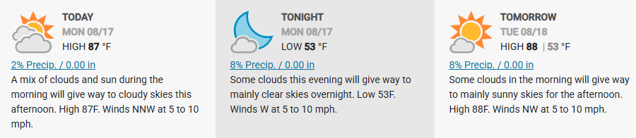

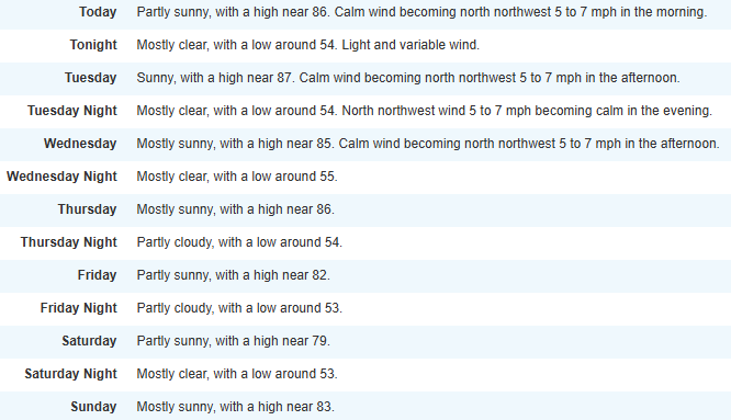
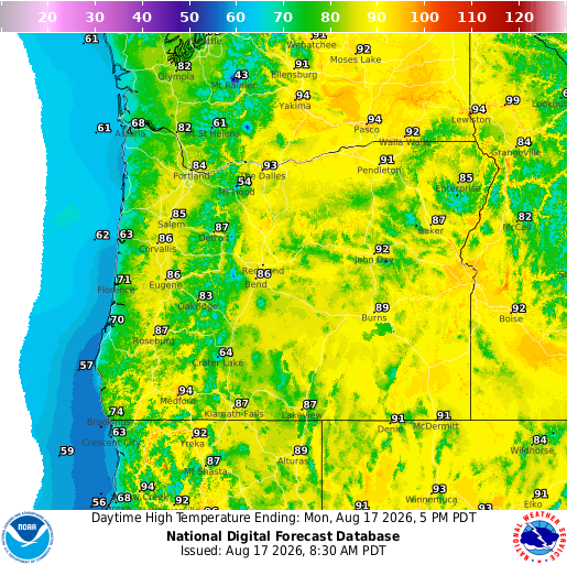
Weather conditions can allow even a small spark to quickly become a fast-moving wildfire. Help us keep Oregon safe by staying vigilant and avoiding activities that could start a fire. One less spark can make the difference.
Pollutants in smoke can cause burning eyes, runny nose, aggravate heart and lung diseases, and aggravate other serious health problems. Limit outdoor activities and keep children indoors if it is smoky. Please follow medical advice if you have a heart or lung condition. https://www.facebook.com/reel/1430921498857533

Be sure to check out what we’re predicting in your area: https://www.farmersalmanac.com/extended-forecast

Please be #WildfireAware, know the evacuation levels, sign up for emergency alerts, and have a plan in the event you need to evacuate because of wildfire. FORECAST: www.weather.gov/fire SIGN UP: https://oralert.gov
As a reminder, the following are prohibited: Debris burning — Smoking in forestlands — Use of fireworks — Sky lanterns & target practice with exploding targets
Allowed only before 10 am and after 8 pm: Chainsaw use — Cutting, grinding, welding – Mowing/cutting of dried grass — Off road motorized vehicle use — Any other spark emitting internal combustion engine
It’s already extremely dry. Our ask: prevent sparking a wildfire. Check your tow chains. Don’t mow tall dry grass in the heat of the day Don’t park on tall dry grass
We’ve got prevention tips posted to our website to share with your friends and family. LEARN MORE: https://www.oregon.gov/…/pages/prevent-wildfires.aspx
U.S. Forest Service – Willamette National Forest
Due to continued hot and dry weather and critically dry fuels, the Willamette National Forest will move into Stage 2 Fire Restrictions at 12:01 a.m. on Monday, Aug. 17 to help prevent wildfires.

The restrictions are for all Willamette National Forest lands, including within developed campgrounds and Wilderness areas. Stage 2 Fire Restrictions prohibit: Fires, campfires, and stove fires, including solid fuel, charcoal briquette, gas/jellied petroleum, pressurized liquid fuel or propane. Devices fueled by liquid petroleum or LPG fuels that can be turned on and off are permitted when operated within a 3 foot perimeter devoid of vegetation. Chainsaw use. Generators must have a spark arrestor and be located in an area cleared of flammable material in a 10-foot diameter. Welding. Explosives. Use of vehicles off designated National Forest System roads and trails. Do your part to help firefighters by preventing human-caused wildfires. More info: https://www.fs.usda.gov/…/temporary-fire-restrictions

Lane County Announces 2026–2027 Community & Economic Development Grant Applications
Beginning August 19, Lane County will begin accepting applications for the 2026–2027 Community & Economic Development (CED) Grant Program. This competitive grant opportunity is designed to support high-impact projects or programs that increase wages or jobs, provide business assistance, support business innovation, and revitalize Main Streets, downtowns or commercial districts across Lane County.
.png)
To support applicants in creating strong proposals, Lane County will host a virtual informational webinar on Wednesday, August 26, at noon. Staff will explain the grant and answer questions from attendees. A recording of the presentation will be made available on the CED Grant website.
The CED Grant Program is soliciting applications from 501(c)(3) nonprofit organizations operating in Lane County and cities serving Lane County residents. There is $200,000 in funding available to provide grant awards between $5,000 and $30,000. Priority will be given to proposals that foster inclusive economic growth and align with the County’s strategic development goals.
“The Community and Economic Development Grant is a helpful resource that we are proud to offer,” said Jason Harris, Lane County’s Community and Economic Development manager. “We are always so impressed with the ways our cities and community partners leverage these funds to increase prosperity and support our business community throughout the region.”
Program objectives include:
- Increasing employment or wages in targeted sectors including advanced manufacturing, healthcare, food and beverage manufacturing, biosciences, technology, and childcare.
- Facilitating industry or business innovation, engagement or business development which may include supporting accelerators, incubators, or apprenticeship programs.
- Providing business technical assistance, training or support services to entrepreneurs, start-ups, and small businesses.
- Improving Lane County downtowns and Main Streets by revitalizing physical and visual assets to create a business-friendly environment.
Application Details and Timeline
- Applications will be available to download on Lane County’s procurement site, Bid Locker, starting August 19, 2026.
- A virtual informational webinar will be presented Wednesday, August 26, at noon at www.LaneCountyOR.gov/CEDgrant.
- Submissions must be sent via email to CED@LaneCountyOR.gov.
- Applications are due by 5:00 p.m. on Friday, September 25, 2026.
- Only one application per organization will be accepted.
- Late or incomplete applications will not be considered.
Applications will be screened for completeness and then evaluated using four core criteria: economic development impact, outcomes and performance, program clarity, and budget and funding. Bonus evaluation points are given to programs or projects that address under-represented or underserved populations, add value to our economy, and for applicants who have not received CED grant funding previously.
Learn more by visiting www.LaneCountyOR.gov/CEDgrant or by contacting CED@LaneCountyOR.gov.
Las solicitudes y aplicaciones también están disponibles en Español.
About Lane County Community and Economic Development:
Lane County Community and Economic Development is your Oregon Video Lottery dollars at work! Community and Economic Development programs support building vibrant communities by partnering with local business, supporting organizations, cities, special districts and economic development agencies to facilitate community development and create economic prosperity. This program fosters economic opportunity across Lane County with a specific focus on rural and unincorporated communities.
House Fire Damages Vacant Home In Eugene
Eugene Springfield Fire responded to a house fire near downtown Eugene early Sunday morning. Just after 5 AM on August 16th, a caller reported thick black smoke coming from a vacant home in the 1400 block of Ferry St.

Engine 1 from the downtown station arrived in under 4 minutes to find the single story home heavily involved in fire. Crews quickly went to work to suppress the fire and search for any potential victims.
There were no victims located or injuries reported. The fire required extensive overhaul and crews were on scene for over two hours. The fire is under investigation.
Firefighters Contain Fire In North Springfield
August 15th, 2016. Eugene Springfield Fire responded Saturday afternoon to a mobile home fire at the Filbert Grove Mobile Home Park in North Springfield near RiverBend Hospital.

Just after 3 p.m., firefighters were dispatched to a reported kitchen fire in a mobile home at the park. Engine 5 from the Gateway Station arrived approximately five minutes later and found a double-wide mobile home well involved in fire, with flames threatening a neighboring home.
Firefighters were advised on arrival that all occupants had safely evacuated. Crews immediately began attacking the fire while simultaneously conducting a search of the home to confirm no one remained inside.
Even when occupants or bystanders report that everyone has safely evacuated, searching the structure remains a high tactical priority for firefighters. Fire scenes can be chaotic, and there is always the possibility that an occupant remains inside or that another person entered the structure in an attempt to help. Fire crews work to independently confirm that no one remains in danger while suppression operations are underway.
Firefighters contained the fire to the home of origin, and no damage was reported to neighboring homes. No injuries were reported. Eugene Springfield Fire Deputy Fire Marshals are on scene investigating the cause of the fire.
Firefighters Extinguish Small Fire near Hendricks Park In Eugene
August 14, 2026 – Just after 9 a.m. Friday, Eugene Springfield Fire (ESF) was dispatched to a report of a possible brush fire in the 1800 block of Skyline Boulevard near Hendricks Park in Eugene.

While responding, firefighters received multiple reports from area residents who reported seeing smoke, with some callers also reporting visible flames. Crews arrived and patrolled the Skyline Boulevard and Hendricks Park area but were initially unable to locate any signs of an active fire.
Additional callers then reported a possible fire near the 2500 block of Potter Street. Crews continued searching the surrounding area and ultimately located a burning compost pile in the 2500 block of University Street near the Masonic Cemetery.
Firefighters quickly contained the fire to the compost pile. Flames had begun to spread to nearby large trees, but crews were able to prevent further extension. The fire is contained, and there is no ongoing threat to the community.
The incident serves as an important reminder that compost piles can generate significant heat and, if not properly maintained, may spontaneously combust and cause a fire.
Fortunately, the fire occurred early in the day under overcast conditions and high humidity, which helped prevent significant fire spread. However, the location is within a high-risk fire area, and a similar incident occurring during hotter, drier weather or Red Flag conditions could pose a much greater threat.
Eugene Public Works supported ESF during the response. Deputy Fire Marshals also worked with the property owners and instructed them to relocate the compost pile to an area farther away from nearby trees.
EWEB will keep power lines in neighborhoods at higher risk for wildfire on “wildfire safety settings” for the rest of the summer.

Approximately 10% of EWEB customers — primarily in the South Hills and Southwest Hills — are served by these circuits and may experience more frequent and longer outages than they would under normal operating conditions. Depending on conditions, these settings will remain in place until late September or early October — an investment in resiliency during a high-risk season. Read more details at: https://www.eweb.org/…/eweb-to-maintain-wildfire-safety…
City of Springfield, Oregon Government · We are hiring!

Looking for an opportunity to make a difference in the Springfield community? We are hiring for several positions across the organization: • Public Works Technician | Apply by August 30 • Senior Planner | Apply by September 7
From maintaining the services our community relies on to planning for Springfield’s future, there are many ways to build a meaningful career in public service. Learn more and apply: https://springfield-or.gov/city/human-resources/careers/
Eugene Water & Electric Board and Cascadia Region Earthquake Science Center
·The Cascadia Subduction Zone is capable of a magnitude 9.0 earthquake and strong shaking from smaller earthquakes. The magnitude of this earthquake and the accompanying tsunami pose significant challenges to the entire Pacific Northwest.

Community lifelines will be impacted. Utilities such as electricity, drinking water, and sewer services may be significantly impacted. Understanding what to expect during an earthquake is critical for response, recovery, and whole community preparedness.
That’s why EWEB, the Eugene Family YMCA, and the Cascadia Region Earthquake Science Center have partnered to break down the complexities of understanding and preparing for a seismic emergency.
Representatives from the UO’s Cascadia Region Earthquake Science Center and Earth Science Department will present: – History of earthquakes on the Cascadia Subduction Zone – Why recurrence is likely – What an earthquake will feel like in the Eugene Metro area – What impacts are likely to affect the Eugene Metro area
The session will be offered on the following dates at the Eugene Family YMCA: – Tuesday, September 15, 5:30 – 7:00 p.m. – Wednesday, September 30, 10:00 – 11:30 a.m. – Wednesday, October 14, 1:00 – 2:30 p.m. – Wednesday, October 21, 10:00 – 11:30 a.m. – Monday, October 26, 5:30 – 7:00 p.m.
Register today – spots are limited:https://www.eugeneymca.org/…/communi…/eweb-programming-y
Update to the Motel 6 Shooting in Glenwood

Just before 1 p.m on Thursday, Eugene police have detained two people in relation to this morning’s shooting at Motel 6 in Glenwood. The suspects were taken into custody near 37th and Kincaid. A related vehicle was stopped near an apartment complex in the 3500 block of West Amazon. Those two areas should be avoided by the public, as police continue their investigation.
Eugene police responded to a report this morning of a shooting at the Motel 6 in Glenwood. Just after 8:30 a.m., a woman reported to the hotel’s front desk that her boyfriend had been shot inside of a hotel room.The victim was transported to the hospital and has undergone surgery. He is expected to survive.
Your old phone could help a domestic violence survivor stay connected and safe
That old phone that you aren’t using anymore…it can be a lifeline for a domestic violence survivor. Eugene Police is partnering with non-profit Hope and Safety Alliance to provide phones for survivors and their families.

You can help by dropping off your unwanted phones in secure box in the Eugene Police headquarters lobby, 300 Country Club Road!
Note: the phone needs to be capable of wi-fi. A phone, even without active service can still connect to wi-fi, allowing someone to: • Call or message for help• Access safety planning and community resources• Connect with advocates, shelters, and support systems• Apply for jobs, housing, and benefits• Stay connected during an incredibly vulnerable timeBefore donating, please remember to wipe your phone of your personal information. Directions are included for Android and Apple iPhone. https://www.hopesafetyalliance.org/phones
Hope and Safety Alliance:Hope & Safety Alliance has been providing hope and safety to survivors of domestic violence for over 48 years. Each year they serve thousands of survivors and children from our urban and rural communities in Lane County. Their mission is to protect, shelter, and empower survivors of domestic violence – offering safety, support, and resources with compassion and trauma-informed care. They are a 501(3)c organization and your donation is tax deductible.
Lane County Sheriff’s Deputies Enforce Traffic Safety Using Grant Funding
Lane County continues to make an impact and try to improve roadway safety through public education and enforcement. LCSO Deputies are continuing to utilize grant funding to show an increased presence on county roads.

The reality is, high‑risk driving behaviors, especially speeding, are still increasing. Lane County has consistently ranked among the top three highest counties in Oregon for fatal crashes. According to the Oregon Department of Transportation, Lane County recorded 56 traffic deaths in 2022. 89% of these crashes involved impairment and or speed. Lane County recorded 41 deaths in 2023 and 49 deaths in 2024.
LCSO does not have a full-time dedicated traffic enforcement unit. Most offenders get stopped simply because the deputy happened to be in the right place at the right time and was in between priority calls-for -service. This only raises more concerns about how often these dangerous driving behaviors go undetected.
The Lane County Sheriff’s Office is asking for every driver’s assistance to help keep our roads safe. Please plan ahead. Give yourself extra travel time. Practice patience. Remember we all share the roadway with drivers of all ages and varying levels of experience. Together, we can reduce speeds and make Lane County’s roads safer for everyone.
Willamette Valley Cancer Institute and Research Center Expands Access to Advanced PET/CT Technology to Strengthen Comprehensive Cancer Care Offering
EUGENE, Ore. — [August, 11, 2026] — Willamette Valley Cancer Institute and Research Center (“WVCI”) announces the addition of PET/CT imaging technology with the installation of a new Siemens Biograph Trinion PET/CT scanner at its Eugene location this month. The technology provides patients a new, convenient option for advanced imaging and supports a higher level of coordinated cancer care for patients in the Willamette Valley.
PET/CT imaging combines PET (positron emission tomography), which shows tumor activity and location, with CT (computed tomography), which shows detailed images of the body’s anatomy, in one advanced scan. Together, these technologies help physicians identify health concerns quickly and accurately, supporting early detection, accurate diagnosis, and confident treatment planning.
By using PET/CT imaging early in the care planning process, WVCI care teams can see where cancer may be present and whether it has spread. This information helps physicians determine the stage of cancer, plan the next steps in care, and monitor how well treatment is working over time.
“Our new scanner gives our physicians highly detailed images that can detect exceptionally small areas of concern,” said Tina Nelson, Senior PET/CT technologist at WVCI.
The new PET/CT system is also designed with the patient experience in mind. Faster, lower-dose imaging may help shorten the time patients spend in the scanner and limit radiation exposure. Comfort features, including mood lighting and continued communication with imaging staff, are intended to help patients feel informed, supported, and more at ease during the exam.
“We want the experience to feel as reassuring as possible,” explains Nelson. “The new features help our imaging team do that by staying connected with patients and fostering a calming environment, which helps minimize clinical anxiety.”
The PET/CT technology also supports WVCI’s introduction of radiopharmaceutical capabilities later this year. Radiopharmaceuticals are specialized medicines that contain small amounts of radioactive material and may be used to help diagnose and, in some cases, treat certain cancers. As this program develops, WVCI will share additional information with patients, referring providers, and community partners.
“For patients, this is about more than new technology,” Nelson said. “It brings cutting-edge imaging to where our patients are, alongside the cancer care team they already know. It’s helping reduce the physical and emotional burden of traveling to multiple locations for separate appointments.”
The new PET/CT scanner is available now for patients of WVCI. Details about future radiopharmaceutical capabilities will be shared as they are finalized later this year.
Patients who would like more information about WVCI’s imaging and cancer care services may call 541.683.5001.
About Willamette Valley Cancer Institute and Research Center — The Willamette Valley Cancer Institute and Research Center is a member of the US Oncology Network of over 1,200 independent physicians, dedicated to delivering value-based, integrated care to patients – close to home in Albany, Corvallis, Eugene, Florence, Newport, and Springfield. As part of the Network community, we share expertise and resources to advance local cancer care and deliver better patient outcomes. WVCI also participates in clinical trials through US Oncology Research and Sarah Cannon Research Institute, which have played a role in more than 100 FDA-approved cancer therapies, approximately one-third of all cancer therapies approved by the FDA to date.
City of Eugene Gets Inquiry to Build Data Center at Former Hynix Campus
An unidentified company that has Eugene’s former Hynix campus under contract has asked the city to confirm that a data center and several other uses are permitted under the property’s zoning.
To oppose the proposed data center project at the former Hynix campus, you can contact Eugene city leadership and the planning department through several direct channels. Contact Elected Officials and LeadershipYou can voice your concerns directly to the city council, mayor, and city manager.
- Email: Send your comments to mayorcouncilandcitymanager@eugene-or.gov.
- Phone: Call the City Manager’s office at 541-682-5010.
- Mail: Address physical letters to 500 East 4th Ave, Suite 302, Eugene, OR 97401.
- Rule: Include your full name, home address, or ward number so your comments are officially recorded and distributed. Anonymous comments are not shared with the council.
Contact the Planning and Development DepartmentBecause the current inquiry is undergoing a zone verification review, you can submit inquiries or comments regarding the E-1 zoning requirements to the department handling the request.
- Phone: Call the department directly at 541-682-5086.
- In Person: Visit the Permit Information Center at the Atrium Building, 99 W. 10th Ave, Eugene, OR 97401 (Open for walk-ins Monday–Friday, 12 p.m. to 4 p.m.).
Attend a City Council Meeting
- Public Comment: You can sign up to speak during the public comment portion of regular Eugene City Council Meetings.
- Schedules: Review the upcoming schedule, agendas, and virtual attendance links via the city’s Webcasts and Meeting Materials portal.
FAQs: Understanding City review of allowed uses of the property at 1830 Willow Creek
On July 14, 2026, a request for a Zone Verification was submitted to the City of Eugene that could include “Data Center Use, Manufacturing, Research and Development, Advanced Manufacturing, Warehousing, Office Uses, and customary accessory and support uses associated with those uses” on the former Hyundai/Hynix semiconductor campus located at 1830 Willow Creek Circle in west Eugene. READ MORE: (SOURCE)
Food for Lane County Summer Food Program for Kids
In partnership with PeaceHealth, which donated $50,000 to the program, and Yogi, a tea company that donated $5,000, the program will distribute free lunches at dozens of sites in Lane County from June 22 to Aug. 21.
Click on Lunch locations below:
Creswell Eugene Dexter Junction City Oakridge Springfield Thurston Triangle Lake Veneta
According to Carolyn Stein, the executive director of Food for Lane County, the PeaceHealth donation and Yogi donation helped minimize a funding gap of over $100,000. Even so, Food for Lane County has to pay out of pocket to fill the remaining gap.
According to the Oregon Department of Education, about 75% of Lane County children qualify for free or reduced-cost lunch.
Last year, Stein said the free-food program served about 50,000 meals to kids throughout the summer, and they expect that number to increase by an additional 10,000 this summer.
“Food for Lane County’s mission is to engage our community to create access to food, and we do that with many partnerships with organizations and businesses across the community,” Stein said. “We went to PeaceHealth because they have a shared value to make sure that no child in our community goes hungry and they stepped up in a big way to help us meet the need in our community.”
The lunches will be served on a first-come basis, between 11:30 a.m. and 12:30 p.m., Monday through Friday. Kids, 18 years old or younger, can receive meals, regardless of income.
Burrito Brigade Buys Building to Create Community Food Hub
Burrito Brigade has bought the old Center for Appropriate Transport building at 455 West 1st Ave. in the Whiteaker neighborhood to create a new community food hub.
The organization is asking the community to help support building renovation goals. Burrito Brigade needs $300,000 more to fully complete a commercial kitchen installation, food storage infrastructure, ADA-compliant upgrades and critical improvements needed.

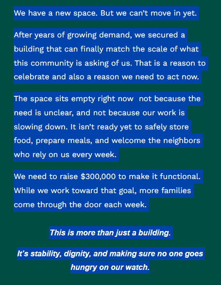
Jennifer Denson says “This project has always been community driven. Since Waste To Taste’s start in 2020 we have not looked back. We just keep rescuing more food and growing more organized and it’s incredible to watch the impact and difference we make when we work together,”
Hundreds of volunteer hours weekly are dedicated to rescuing more than half a million pounds of food annually from grocery stores, small businesses, institutions, large food generators and local farms. This community-powered food rescue serves fresh local vegetables and fruit alongside diet and culturally specific products.
The no-barrier access free grocery store, known as Waste-to-Taste, provides households the ability to supplement other systems of support that often have eligibility requirements. Waste-to-Taste serves more than 10,000 households annually.
Rescued food is also redirected through other sustainable distribution channels. Food scraps and spoiled food are diverted to feed farm animals like chickens, goats and pigs, sanctuary animals at a local emu ranch and wolf rescue, and even a mealworm farm.
According to Burrito Brigade, the community connection and creativity around food in the kitchen includes partners in many mutual aid food projects facilitating hot meals, food preservation, community-led cooking classes, food micro-entrepreneurs and youth workforce training. The new community food hub will open its doors to the public in 2027. You can DONATE here: https://www.zeffy.com/en-US/donation-form/donate-to-help-us-build-a-food-hub

Skinner Butte Park summit parking lot is now closed to motorized vehicles due to fire danger. The closure will remain in effect until October.
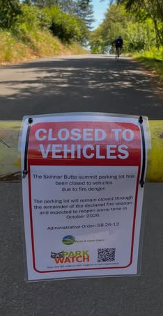
City of Eugene’s Parks and Open Space, in cooperation with Eugene Springfield Fire, have closed the Skinner Butte parking lot and summit road. It will be closed until sometime in October.
There has been a history of illegal firework activity and brush fires, particularly during the summer season.
Closing this area to vehicles helps reduce that risk. The summit will remain accessible to pedestrians and cyclists (no e-motorcycles) by numerous trails and the paved road that leads to the summit.

Lane County will participate by setting up donation barrels for staff to donate at Lane County owned properties.
“Food for Lane County is already seeing high numbers of pantry visitors at a time when our food supply has been limited due to federal program cuts. We want all Lane County residents to have the food and resources they need to thrive, and we’re very concerned about the welfare of our community if SNAP benefits aren’t available.” said Food for Lane County Director of Development and Communications, Rebecca Sprinson.
For individuals and families in need of food, please visit the FFLC food finder, at:
Those interested in donating can do so by visiting: https://www.foodforlanecounty.org/ways-to=give/donate or by calling 541-343-2822.
$18.95 can help feed 120 people.
 Every weekend, the volunteer crew at Burrito Brigade rolls hundreds of delicious vegan burritos to help close the hunger gap here in Eugene. Each box of tortillas — just $18.95 — helps feed 120 neighbors.

Could you spare $18.95 to help? Even better — could you make it a monthly donation to keep those burritos rolling all year long?
Every dollar makes a difference in these times of need. Thank you for being part of the Brigade.  Donate here: https://www.zeffy.com/donation…/we-rise-by-lifting-others Support our Mission: BurritoBrigade.org

White Bird Clinic – · Crisis intervention is a 24/7 need in our community, and CAHOOTS, as part of White Bird Crisis Intervention programs, responds.
White Bird CAHOOTS Springfield Coverage: 11 am – 11 pm, 7 days a week (541-726-3714)
White Bird Clinic
This year marks 60 years of community health centers transforming care across the U.S. At White Bird Clinic, we’re proud to be part of this legacy – bringing whole-person care to our community’s most vulnerable neighbors for more than 50 years! From medical and dental services to harm reduction and crisis response, we’re here to meet people where they are.Learn more about community health at the link below: https://www.nachc.org/about-nachc/history-of-chc/
Whole Community News Report on CAHOOTS:
Since December of 2023, Eugene lost the University District hospital and the Hourglass Crisis Center, and as of last week, CAHOOTS. These were no-barrier treatment access points for our most vulnerable neighbors to receive care when experiencing a mental health crisis. READ MORE: https://wholecommunity.news/2025/04/20/public-comments-ask-city-not-to-lose-cahoots-too/

Contact for Services — Phone: CAHOOTS is dispatched within the Springfield urban growth boundary through the non-emergency number, 541-726-3714.
Starting in the new year, White Bird Dental Clinic will offer more walk-in clinic times. Currently, we offer walk-in clinics at 1415 Pearl St. every Monday and Wednesday at 7:30 a.m. In January, we will also add every other Friday at 7:30 a.m. Find more information at whitebirdclinic.org/dental
EWEB Emergency Water Stations
The final emergency water station has been officially installed in Eugene as part of the Eugene Water & Electric Board’s disaster preparedness plan.
This is where people can access water in case of earthquakes, wildfires, or other events that could disrupt or limit access to the city’s water system.

Other locations are the Eugene Science Center, Howard Elementary School, Prairie Mountain School, Amazon Park-YMCA, the Sheldon Fire Station, and the Lane Events Center and Fairgrounds.
All seven locations across the city of Eugene draw their water from underground wells. The intent is to provide individuals up to two gallons of water a day during an emergency. MORE INFO at EWEB: https://www.eweb.org/projects/emergency-water-stations
Oregon Food Bank · Find free food sites near you using OregonFoodFinder.org.
If you can’t make it to a food location, someone else can pick up food for you.You will just need to print and fill out the Authorized Representative form at https://lnkd.in/dsskUpkQ, and have them take it with them to the food sites. You can find step-by-step instructions at https://lnkd.in/dVBRxn-A.
Worried about recent changes or losing assistance?
Here are resources that can help:
211Info: Dial 2-1-1 or visit the211Info food webpagefor information and referrals to more than 1,500 food resources across Oregon.
Oregon Food Bank: Use the Oregon Food Bank’s Food Finder Mapto find over 100 food pantries, free food markets or hot meal programs near you.
Aging and Disability Resource Connection of Oregon (ADRC): Call 855-673-2372 or visit theADRC food webpage to find local meal programs and food boxes in your area.

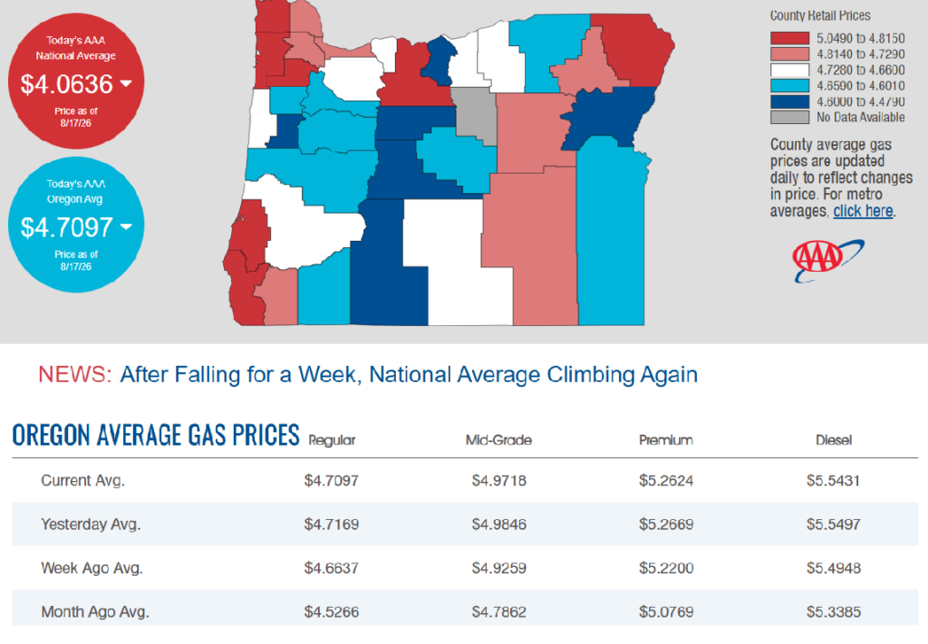
8/17/2026 — Gas Prices in Oregon Today

 PACIFIC NORTHWEST WILDFIRE UPDATE
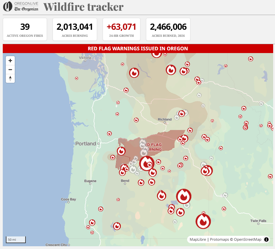
As of August 17, 2026, Oregon is battling its most severe wildfire season in recorded history, with over 2.4 million acres burned this year. There are currently 23 active wildfire incidents across the state, with recent lightning storms continuously igniting new starts and challenging containment lines.
Major Fire Breakdown & Status
- Rowe Creek Complex: Located near Fossil, this massive complex spans 373,783 acres and is 89% contained as fire crews successfully widened lines near Highway 26.
- Grasshopper Fire: Burning near Mount Hood in north-central Oregon, this conflagration has reached ~90,000 acres and is 38% contained. It has destroyed at least six homes, prompted Level 3 “Go Now” evacuations, and threatens the Mount Hood Meadows Ski Resort.
- Shingle Fire: Spanning Crook, Grant, and Wheeler counties, this fire has consumed 73,179 acres and is 89% contained.
- Bench Fire: Burning in Jefferson County near Warm Springs and Lake Billy Chinook, it is holding at 67,079 acres and is 86% contained.
- Austin Fire: Located in Clackamas County near Harriet Lake, this fire has ballooned to over 2,000 acres and recently crossed the Clackamas River.
- Wrights Spring Fire: Active in Klamath County, this fast-spreading fire remains at 0% containment and tragically resulted in the death of a wildland firefighter.
Evacuations & Road Reopenings
- Level 3 (“Go Now”): Active for parts of Wasco, Hood River, and Clackamas counties due to the Grasshopper and Austin fires.
- Level 1 (“Be Ready”): Implemented in Wheeler County and eastern Clackamas County.
- Travel Update: The Oregon Department of Transportation has officially reopened Highway 26 between Prineville and Mitchell, which was previously closed due to the Rowe Creek Complex.
Air Quality & Smoke AdvisoriesThe Oregon Department of Environmental Quality has an active air quality advisory through today for 12 counties, including Clackamas, Crook, Hood River, Jefferson, Wasco, Wheeler, and Deschutes. Heavy smoke is causing highly reduced visibility and unhealthy breathing conditions across central and eastern Oregon.
For real-time evacuation zones, check the local county sheriff’s pages, monitor highway updates via TripCheck, or view the interactive tracking tools via The Oregonian Wildfire Tracker.
🗺️ Critical Resources for Evacuations & Travel — Because fire behavior, road closures, and air quality fluctuate rapidly, residents should utilize official tracking platforms before traveling:
- Evacuation Maps: Check real-time statuses using Oregon’s RAPTOR tracking map or local county sheriff’s pages.
- Road Closures: View live traffic adjustments and highway conditions on TripCheck.
- Smoke Updates: Track local pollution and breathing safety recommendations via the Oregon Smoke Information Blog.
🚨 Fielder Mountain Fire
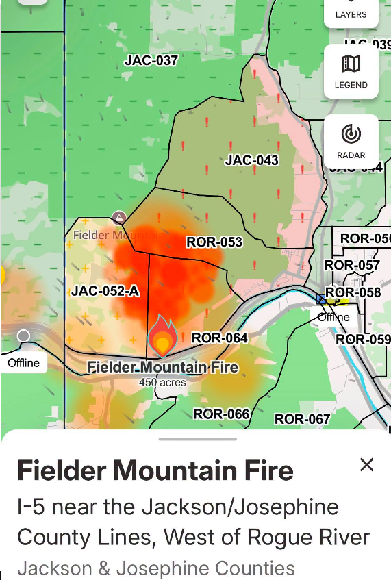
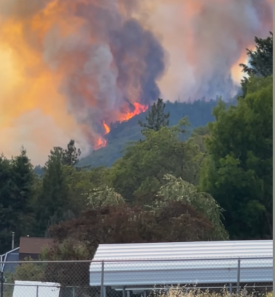
Location: Near Interstate 5, between Grants Pass and Rogue River (Southern Oregon).
𝗙𝗶𝗿𝗲𝗳𝗶𝗴𝗵𝘁𝗶𝗻𝗴 𝗲𝗳𝗳𝗼𝗿𝘁𝘀 𝗵𝗲𝗹𝗽 𝗶𝗻𝗰𝗿𝗲𝗮𝘀𝗲 𝗰𝗼𝗻𝘁𝗮𝗶𝗻𝗺𝗲𝗻𝘁 𝗼𝗻 𝗙𝗶𝗲𝗹𝗱𝗲𝗿 𝗠𝗼𝘂𝗻𝘁𝗮𝗶𝗻 𝗙𝗶𝗿𝗲
ROGUE RIVER, Ore. – Overnight, crews at the Fielder Mountain Fire, west of Rogue River, focused on mop-up operations along the fire’s perimeter. Near structures, firefighters have extended mop-up efforts to 300 feet and continue to monitor these locations to ensure no residual heat flares up and threatens homes. In other areas, mop-up has progressed 50 feet into the interior with the goal for today to keep that momentum going by strengthening the fire line and working deeper into the burned areas.
As containment increases, crews are beginning to shift from night to day operations, while others are being released to rest and recover for future assignments. The safety and well-being of firefighters remains a primary focus, supported by consistent access to care and meals. Resources from the fire are ready to respond quickly, supporting local agencies if new fires occur. Firefighters during night shift used thermal imaging cameras and Unmanned Aircraft Systems (UAS) equipped with infra-red technology to identify areas of heat that cannot always be seen during the day, allowing firefighters to pinpoint hotspots that require attention to secure the fire line as mop-up efforts continue.
Today, firefighters will continue work to extinguish these areas of heat.Rugged terrain in the northern part of the fire and poor road access are limiting water delivery for mop-up activities. Helicopters are continuing to provide support by filling up portable tanks for hose lays, ensuring enough water for a thorough mop-up. Even with the challenge of steep slopes, rolling rocks, and falling trees, fire line crews are progressing well into the interior of the fire. Firefighters remain on high alert for any spotting outside the perimeter and are working to take down dangerous snags to create a safer working environment for firefighters.
Evacuation levels were reduced on Saturday as crews continued progress strengthening control lines around the fire; visit https://readyjacksonco.com/…/emergency-information-hub… for current evacuation information. Livestock assistance is still available by calling (541) 864-0546. Road closures around the fire have been lifted, however, fire personnel are still working in the area; please be aware and drive carefully if you need to be in the area.
Conditions are expected to warm up today as temperatures climb into the low 90s, with low humidity levels and light winds increasing in the late afternoon. Evacuations: Evacuations have been issued by the Jackson County Sheriff’s Office and Emergency Management. Up-to-date evacuations are available here: https://readyjacksonco.com/…/emergency-information-hub…Find your evacuation zone here: https://protect.genasys.com/enRoad/Land Closures: All road closures around the fire have been lifted. All road closure information is available on https://tripcheck.com/
Smoke Impacts: Smoke from the Fielder Mountain Fire may settle into valleys and other low-lying areas, reducing visibility and impacting air quality in nearby communities. Individuals sensitive to smoke should take appropriate precautions. For current air quality information and smoke forecasts, visit: https://fire.airnow.gov/Temporary Flight Restriction
(TFR): A “TFR” is in place for the fire area daily (24 hours) until further notice. Complete information is available at https://tfr.faa.gov/tfr3/?page=detail_6_5072 Flying a drone near or around a wildfire is illegal, compromises the safety of both pilots and firefighters, and interferes with firefighting efforts.
Cause: The fire started on Thursday, August 13 shortly after 3 p.m. Initial reports indicated tires on a semi-truck were on fire and flames had spread to nearby vegetation; the official cause remains under investigation.
Dozer Operator Killed While Fighting Wrights Spring Fire Honored Saturday
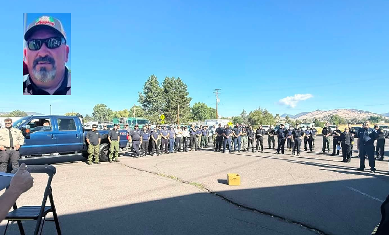
Honor Guard service for dozer operator Jason Ensign held on Saturday, August 15th.
Flags at all Oregon public institutions were lowered Friday in honor of Jason Ensign, the dozer operator who died in the Wright Springs Fire.
An honor guard service was held for Jason Ensign, a 47-year-old dozer operator who died while battling the Wrights Spring Fire.
A GoFundMe has been started for Jason’s daughter. Click here to visit.
Wrights Spring Fire Update August 17, 2026
Website: https://inciweb.wildfire.gov/inciden…/orfwf-wrights-spring Email: 2026.wrightsspring@firenet.gov Phone: 541-712-4438Social Media, Evacuation and Closure Information: https://linktr.ee/2026.wrightsspring Smoke Outlook: https://outlooks.wildlandfiresmoke.net/outlook/6c74f4c6

Acres: 53,941 | Containment: 51% | Detection: 08/05/2026 | Cause: Undetermined Personnel: 942 | Location: 2 miles west of Sprague River, Oregon
Operational Update: Yesterday, day and night shift firefighters secured and mopped up hotspots near the line in the north half of the fire. In the southeast corner of the fire, crews addressed a couple hotspots in the Horton Rim area. Crews continued making good progress in the south and lower west area of the fire, securing line and increasing the mop up depth. Crews addressed a spot fire located outside the fire-containment line near Hildebrand Road. With the recent rain, high humidities and calmer winds, firefighters have been able to build direct line along the southwest side of the fire to better meet incident objectives (e.g., minimize impacts, minimize acres burned, protect Tribal, cultural and natural resources).
In the Swan Lake Point area, firefighters addressed flare ups and improved line. The equipment group worked their way through the fire interior from the north, moving into the Swan Lake Point area in preparation for constructing line on the western side of the fire.
Today crews will continue to secure and increase mop up depth around the north half of the fire, and in the southeast and along southern portions of the fire. On the southwest side of the fire, crews will continue building direct line to the north.
In the Swan Lake Point area, crews will continue constructing direct line southeast to close off the west side of the fire. Weather: Mostly cloudy skies this morning dissipating in the early afternoon. Warm, light wind conditions today.
Temperatures on the ridgetops high-70’s, valleys low 80’s. Minimum HR Humidity 17-20%.Evacuations: Multiple levels of evacuation are in effect. Klamath County evacuation zones and levels can be found at: https://protect.genasys.com/…/42.403038%2C-121.471546… Shelter Locations:For people (okay to bring small animals): • Red Cross emergency shelter is open at Chiloquin Elementary School, 548 S 2nd Ave in Chiloquin.• Red Cross emergency shelter is now open at Living Springs Fellowship, 31897 Mission St. in Bonanza. For large animals only: • Contact Maria Meister, Southern Oregon Emergency Aid (SOEA), at 831-235-3031, to shelter large animal(s) at the livestock area of the Klamath County Fairgrounds.
Road Closures: Bliss Road is closed, from Petersteiner Road to Sprague River. Areas around Wrights Spring Fire are experiencing high volumes of fire traffic and ongoing suppression activity. Firefighter safety remains the top priority and the public is asked to avoid unnecessary travel to prevent congesting traffic.
Forest Closures: The Fremont-Winema National Forest issued an Emergency Closure Order on August 09, 2026. https://www.fs.usda.gov/…/fire-area-emergency-closure No Fly Zone: A Temporary Flight Restriction (TFR) over the area remains in effect. Flying drones near the fire is prohibited and can interfere with firefighting aircraft, potentially grounding aerial sup-pression operations. http://knowbeforeyoufly.org.
DONATIONS NEEDED FOR FIRE VICTIMS
The Klamath County Chamber of Commerce is asking the public for animal supplies and gas cards as the Klamath County Event Center and Fairgrounds houses 713 animals.
Grass hay, dog food, cat food, chicken feed and pig feed are some of the supplies being asked for as more animals are expected to arrive. Small food and water bowls, no matter the size, are also encouraged. Donations don’t need to be brand new and all donations will find a purpose.
Equipment like bungee cords and stackable wire cages are being asked for by the community for cages and security for animals. Gas cards are also being sought after as community members have been using their own vehicles and money toward assisting with animal evacuations and helping others.
As for food, donate to the Klamath Lake Food Bank. As for animal donations, the Chamber of Commerce asks those donating to enter the Klamath County Fairgrounds through Gate 3 on the Senior Center side. Donations will be available from 7 a.m. to 9 p.m. Gas card donations can be made at Ezell Suty Fuel, 2360 S. 6th Street.
Evacuations for people in need, are located at Chiloquin Elementary and Living Springs Church in Bonanza.
The Klamath Karavan is stepping up to help families affected by the Wright Spring Fire, and they need your help! Donations of bottled water, Powerade, Gatorade, light jackets, sweaters, socks, pet food—and lots of prayers are greatly appreciated. You can drop off donations at Starvn Marvn’s, 1822 Austin Street in Klamath Falls. Every donation, big or small, can make a difference for our neighbors who are going through a difficult time.
Wildfire smoke and evacuation threats can take a toll on mental health
Staying connected, taking breaks from the news and seeking support can help people cope during wildfire season
Wildfires can affect more than the air we breathe. The uncertainty of an approaching fire, evacuation warnings, disrupted routines, loss of property or community, and prolonged exposure to wildfire smoke can create stress, anxiety, grief and other emotional responses.
As wildfires and smoke continue to impact communities across Oregon, Oregon Health Authority (OHA) is reminding people that supporting mental health is an important part of wildfire preparedness and recovery.
“It’s completely understandable to feel uneasy when wildfires are threatening our communities or when smoke is affecting the air we breathe,” said Dean Sidelinger, M.D., M.S.Ed., OHA health officer and state epidemiologist. “These conditions can take a real toll on our physical and mental health. Taking care of ourselves, staying connected with others and knowing where to turn for support can help us cope during these difficult times.”
Wildfire stress can affect anyone.
People may experience a range of emotions during and after a wildfire, including fear, sadness, anger, grief, helplessness, trouble sleeping or difficulty concentrating. Children and teens may also have strong emotional reactions, even when they do not directly experience a fire or evacuation.
People who have experienced previous disasters or wildfire losses may find that a new fire or smoke event brings back difficult memories.
OHA recommends several ways people can support themselves and others:
Check in with neighbors, friends and coworkers – simple conversation can help people feel less alone. Reach out to people who may need additional support, including older adults, children, people with disabilities and those who may have difficulty evacuating or accessing resources.
Create space to express emotions — Give people permission to talk about what they are experiencing at their own pace and without judgment. This can be especially important for children and teens.
Encourage rest and recovery – Healing takes time. Maintaining routines when possible, getting enough rest and reconnecting with people and activities that bring comfort can help restore a sense of stability.
Take breaks from the news and social media – Staying informed is important during an emergency, but continuously monitoring wildfire coverage can increase stress and anxiety. Check trusted sources for updates, then give yourself permission to step away.
Prepare for evacuation – Having a plan can reduce some of the uncertainty that comes with a wildfire threat. Know your evacuation zone and routes, sign up for emergency alerts, keep important medications and documents accessible, and have a go-bag ready.
Protecting mental health during smoke events
People do not have to navigate the emotional effects of wildfire alone.
- 988 Suicide & Crisis Lifeline: Call or text 988 for free, confidential crisis support.
- Lines for Life: 800-923-HELP (4357) provides emotional support and help connecting with resources. Oregon’s wildfire recovery resources also direct people to Lines for Life for emotional support, with interpreters available.
- YouthLine: Young people can call 877-968-8491 or text teen2teen to 839863 for support.
- The AgriStress HelpLine is a free, 24/7 hotline for Oregon’s agricultural and forestry communities, including farmers, ranchers, fishermen, foresters, and their families. Call or text: (833) 897-2474. Helpline operators are trained to understand the unique stressors and situations of agriculture, forestry, and fishing. All calls are answered within 30 seconds.
People affected by a wildfire who need help finding food, shelter, health care, emotional support or other services can also connect with 211 for local resources.
Support for children and teens
Parents and caregivers can help children feel safer by providing reassurance, maintaining routines when possible and giving children opportunities to ask questions and express their feelings.
During a wildfire or evacuation, children may need additional reassurance and opportunities to reconnect with familiar people and routines. Adults can model healthy coping behaviors by taking breaks, getting rest, talking with others and asking for help when needed.
Additional resources:
- Wildfires and smoke: Oregon Health Authority wildfire resources
- Crisis and trauma resources: OHA Resources for Crisis and Trauma Response
- Wildfire recovery assistance: Oregon Department of Human Services – Get Help After a Wildfire
- Oregon wildfire preparedness and evacuation information: Oregon Department of Emergency Management
Oregon Health Authority · Emotional responses like fear, sadness, anger, or fatigue are natural and OK in the aftermath of a disaster.
However, if these feelings become prolonged, overwhelming, or begin to interfere with daily functioning, it may be a sign that someone needs additional mental health support.
It’s important to recognize when a normal reaction shifts into something more concerning.Being aware of this distinction can help individuals and communities respond with compassion and connect people to the help they need. If you need help, call or text the Disaster Distress Helpline at 800-985-5990.
Oregon state agencies remind everyone to be informed and prepared

— With the National Weather Service issuing a fire weather watchs across large portions of north‑central, northeast and southeast Oregon, the state’s public safety services, natural resource agencies, and tourism office want to remind residents and visitors to practice wildfire prevention, prepare their home and a go-bag for evacuation, and know where to go for real-time alerts and information.
According to the Northwest Interagency Coordination Center’s predictive services, each year the Pacific Northwest is at elevated risk of significant fires from now until October.
With fire crews responding to new fire starts every day, Oregonians and our visitors need to be prepared for wildfires, help prevent future ones, and be aware of up-to-date conditions as they travel across the state.
How can people help prevent wildfires?
The Oregon Department of Forestry is urging the public to actively practice wildfire prevention as the state continues to put out new fires every day. Additional human-caused fires on the landscape will draw the firefighting efforts away from the lightning-caused fires and put extra strain on ground and aviation resources, which are already spread thin. YOU can help prevent wildfires by:
- Checking and following your local fire regulations. The majority of the state is either in high or extreme fire danger right now, meaning even the smallest of sparks could start the next large wildfire.
- Debris burning may be prohibited where you live.
- Check local restrictions or contact your local ODF office.
- Return to check on your burn site if you burned earlier in the year.
- Make sure your car has been recently serviced to avoid faulty parts throwing sparks.
- Don’t drag tow chains.
- Avoid parking vehicles on tall, dry grass.
- Recreate responsibly. Where campfires are allowed, make sure your campfire is DEAD OUT before leaving it by drowning it with water, stirring it with a shovel and repeating that process until it is cold to the touch. If there is heat coming off it, there are still embers that could reignite.
Take Simple Steps to Protect Your Home from Wildfire
The Oregon State Fire Marshal reminds Oregonians that summer is not the safest time to tackle large landscaping or defensible space projects. Hot, dry conditions increase the risk of starting a fire from using tools or equipment. There are small, safe steps you can take now to reduce wildfire risk around your home. The Oregon State Fire Marshal encourages everyone to plan ahead and do light cleanup tasks that protect your property without increasing fire danger.
Easy tasks to reduce risk in the first five feet around your home:
- Clear leaves, pine needles, and other debris from your roof, gutters, and under decks.
- Trim plants and bushes that are touching your home or growing under roof eaves. Give trees and shrubs space from each other and from structures.
- Remove dead plants and wood mulch. Use nonflammable materials like rocks or gravel near your home. Avoid bark mulch or dry grasses right next to buildings.
- Move firewood, propane tanks, and other flammable items at least five feet away from your home.
- Cover attic vents, soffit vents, and spaces under decks with 1/8-inch metal mesh to block embers.
Avoid using power tools or equipment that could spark a fire, especially during the heat of the day. Summer is a good time to plan defensible space projects, so you’re ready to work safely once wildfire season ends.
For more tips or help with defensible space, visit www.oregondefensiblespace.org or https://preventwildfires.oregon.gov.
How can I prepare myself in case I need to evacuate?
The Oregon Department of Emergency Management (OEM) urges everyone to prepare for wildfires and other emergencies by knowing evacuation levels, staying informed, having a plan, and having a go-kit ready.
Evacuation Levels
- Oregon follows a three-level evacuation notification system, each structured around safety threat level.
- Oregonians should become familiar with “Be Ready, Be Set, Go!” evacuation levels to make informed decisions when receiving evacuation notices.
- OEM urges people to evacuate whenever they feel unsafe, conditions can change rapidly; individuals should always make the best decision for their safety.
- Following evacuation, people should not return to the area until public safety officials state it is safe.
Stay Informed
- Stay informed, sign up to receive evacuation at, ORAlert.gov remember to update information if need be.
- Find the websites for your county emergency management, sheriff’s office, or tribal police and follow them on social media.
- Check your phone settings to ensure wireless emergency alerts are turned on.
- Build redundancy into how you can access alerts. Have a personal C.E plan for what you will do if your cell phone stops working. A good place to start is a hand-cranked NOAA radio.
- If you use a third-party app for alerts and situational awareness and notice discrepancy information, default to the information provided by your local emergency management office.
Have a Plan
- Do you know what to do during an evacuation? This evacuation checklist explains what to do before, during and after an evacuation.
- Establish a communication plan with a list of important contacts and a safe place for loved ones to meet if they are separated during an emergency.
- Identify multiple evacuation routes from home, work, or school and plan for transportation needs.
- People with disabilities should consider individual circumstances and specific needs when planning for evacuation, such as special equipment, transportation, and service animals. Then plan extra time, when possible, this may mean treating a level 2 notice like a level 3 notice.
- Have an evacuation plan for pets, make a pet evacuation kit in a tote bag or pet crate, and plan for transportation and sheltering of large animals such as horses and other livestock.
Make a Go-Kit
- Assemble an emergency kit of essential supplies that can be grabbed quickly.
- Pack an easy-to-carry backpack or bag for each household member with health and safety items such as food, water, medication, flashlights, phone chargers, clothing, and important documents. Visit American Red Cross to learn more.
- Find more information and resources at Wildfire.Oregon.gov.
Recreate Responsibly
Oregon Parks and Recreation Department (OPRD) encourages visitors to know before they go when it comes to campfire restrictions. OPRD coordinates with local fire officials throughout the summer and bans open flames in high-risk areas around the state until conditions improve. Please check park webpages or the current fire restrictions list before your next visit. Thank you for helping to reduce the risk of wildfires.
Additionally, many waterways in eastern Oregon are currently being used by firefighting aircraft. Stay clear of the center of major waterways. Recreational boats can block aircraft from accessing the water, which means they will not be able to retrieve water to help put out nearby wildfires.
Occasionally, OPRD will need to evacuate a state park. Evacuations occur at level 2 or earlier depending on fire conditions and the time required to get in and out of the park. Please follow park ranger instructions to pack gear and evacuate. Any park closure information will be posted on the park web page and OPRD social media.
How do I know if I should change my vacation plans?
Oregon is a large state, and while wildfires can disrupt travel in some regions, those impacts are often localized and can change rapidly as conditions improve or deteriorate. Because of this, it’s important to check current alerts at the resources below to see whether your destination is affected. If you’re looking for general guidance about traveling during wildfire season, read Travel Oregon’s Wildfire Travel FAQ.
Before You Go:
- Check road conditions at TripCheck.com or by calling 511.
- Review and follow all local fire restrictions and closures.
- Be aware of air quality conditions that could impact health and visibility.
- View real-time hazard updates, maps, and fire information through OEM’s Wildfire Dashboard.
- Sign up for emergency alerts at ORAlert.gov and ensure Wireless Emergency Alerts are enabled on your mobile device.
Voters in Oregon will have the opportunity to weigh in on a statewide initiative aimed at enhancing controlled burns to mitigate wildfire risks.
The proposed Oregon Controlled Burn and Wildfire Prevention Act mandates the Oregon Department of Forestry to create and oversee a comprehensive controlled burn program. This initiative seeks to prevent catastrophic wildfires by safely incinerating hazardous vegetation before it can contribute to larger blazes.
The department will assess both public and private lands to determine their suitability for controlled burns, prioritizing areas that are at high risk for wildfires and regions where forests are in close proximity to communities. Controlled burns, as defined by the initiative, are carefully planned fires conducted by trained professionals under specific weather and fuel conditions.
These measures are intended to diminish hazardous vegetation, enhance ecosystem health, and safeguard local communities.
Oregon Division of Financial Regulation offers insurance tips for Oregonians affected by wildfires

The Oregon Division of Financial Regulation (DFR) has tips for homeowners and renters who have evacuated or been affected by wildfires, smoke, or ash damage.
“We know this is a hard time for many Oregonians as wildfires affect communities across the state,” said Oregon Insurance Commissioner TK Keen. “We want people to have these tips so they know what their insurance covers and what steps to take if they are affected by a wildfire.”
- If you were evacuated, save your receipts. Your homeowners policy may pay for expenses such as lodging, food, and even pet boarding due to a mandatory evacuation. Be sure to check with your insurance company or agent to confirm your specific coverage. Coverage is typically available for fire, smoke, and ash damage to your home and personal property.
- Additional living expenses (ALE) are typically subject to your deductible, so before you file a claim, be sure it makes sense to do so. It is important to note that a claim can be counted against you for underwriting purposes, even if the insurance company does not make a payment. Most homeowners and renters’ insurance policies help pay for extra expenses such as ALE if you are unable to live in your home. Every company handles these expenses differently. Check with your company or agent for specifics.
- If you have not evacuated and it is safe to do so, make a quick home inventory list by taking photos or video of each room in your home. Pay close attention to what is on the walls and in drawers and closets. Don’t forget storage areas such as the attic and garage. You can also check your insurance company’s website for an app or checklist that will help. Creating that list will help you after a fire or disaster. If your personal belongings are damaged, the insurance company will request a list of items that are damaged or destroyed. Take some time to work on your home inventory list now. Look through your photos and videos to help recall personal items. Be sure to look for smaller items, such as jewelry. To the best of your ability, write down the age, original cost, and replacement cost of each item.
- Ask about your auto coverage, too. You need comprehensive coverage on your auto policy to cover fire, smoke, and ash damage, no matter where your vehicle is located at the time of loss.
Following these tips will help save you money, time, and stress during a wildfire and its aftermath. For more information on preparing for a wildfire, visit DFR’s wildfire page.
If you still have questions or concerns, DFR’s consumer advocates are here to help. Call the team at 888-877-4894 (toll-free), email them at .insurancehelp@dcbs.oregon.gov“>dfr.insurancehelp@dcbs.oregon.gov, or visit dfr.oregon.gov.
### About Oregon DFR: The Division of Financial Regulation protects consumers and regulates insurance, depository institutions, trust companies, securities, and consumer financial products and services. The division is part of the Department of Consumer and Business Services, Oregon’s largest consumer protection and business regulatory agency. Visit dfr.oregon.gov and dcbs.oregon.gov.
Statewide hotline available for Oregonians affected by wildfires and smoke
People anywhere in Oregon who have been affected by wildfires or wildfire-related air quality can call 1-833-699-0554 24 hours a day, seven days a week.


The statewide hotline is available to people experiencing any wildfire-related impact, including those who:
- Lost a home or property
- Evacuated and have ongoing needs
- Are sheltering in place and have wildfire-related needs
- Are affected by wildfire smoke or poor air quality
- Have another need or concern caused by a wildfire
“During this difficult wildfire season, Oregonians impacted by fires deserve immediate and reliable access to the help they need,” said Governor Tina Kotek. “That’s why we’ve established a dedicated, 24/7 hotline – so that no Oregonian has to navigate this wildfire season alone or wonder where to turn to for help.”
The hotline is staffed by 211info. If a call is not answered, callers can leave a message and will receive a return call within one business day.
This hotline does not provide emergency evacuation assistance or help people locate immediate shelter. People who are in immediate danger, have a medical emergency, or need emergency help evacuating should call 911. People looking for information about shelters or other immediate resources can call 2-1-1. For current 211info operating hours, visit 211info.org.
People can also enter their contact information and describe their wildfire-related needs using the Oregon Wildfire Assistance web form. An ODHS staff member will review the information and follow up with them.
“This wildfire season is already affecting a growing number of Oregon Tribes and communities,” said Ed Flick, Director, ODHS Office of Resilience and Emergency Management. “Wildfires can affect people in many ways, even when their homes have not burned. We want people to know there is one place they can call to share what they are experiencing and learn what resources may be available.”
In previous years the hotline has been used to connect people who lost homes in disasters with recovery support. This year, the Oregon Department of Human Services is expanding it to people experiencing a broader range of wildfire impacts.
ODHS has informally coordinated individual assistance following Oregon disasters since 2020. This year, Governor Tina Kotek directed ODHS to be ready to formally activate individual assistance when needed as the state prepares to establish a formal program in 2027 under House Bill 4121.
211info and ODHS will work with local communities to connect people with existing programs and local resources. If those resources are not enough to meet the level of need, ODHS will work with state leaders to identify additional support and funding options.
The hotline does not guarantee financial assistance or eligibility for a particular program. Staff will listen to each caller’s experience, document their needs and help identify available resources and next steps.
Hotline information
- Call: 1-833-699-0554
- Available: 24 hours a day, seven days a week
- Missed calls: Leave a message and your call will be returned within one business day
- Shelter and other immediate resource questions: call 211
- Emergencies or emergency evacuation help: call 911
New survey asks Oregonians how they want transportation dollars spent
The group tasked with developing recommendations on how to maintain Oregon’s transportation system wants to hear from Oregonians about what they think the state’s transportation priorities should be in a new survey. Oregonians can take the survey online at https://www.cognitoforms.com/ODOT2/ROTVSurvey.

The Oregon Department of Transportation is facing a $200 million budget shortfall in the 2027-29 budget cycle. The gap marks the fifth budget cycle in a row where the agency will have to cut services and staff unless the Oregon Legislature finds a way to provide additional revenue. The agency’s budget shortfall stems from the rising cost of materials and labor, as well as flattening gas tax revenue as more people drive fuel-efficient and electric vehicles.
After spearheading several unsuccessful attempts at finding new revenue for the state’s massive transportation agency, Gov. Tina Kotek convened 12 transportation and business experts to participate in a workgroup to help come up with solutions to the agency’s budget gap. The group has until the end of the year to deliver funding recommendations to Kotek, though lawmakers asked to receive recommendations earlier.
The survey asks Oregonians their top six transportation priorities, how they think the agency should spend its limited funding and what reductions would impact them the most.
Oregonians have until 6 p.m. Sept. 10 to complete the survey. Oregonians can also send their feedback to the workgroup’s email at rebuildingtransportation@odot.oregon.gov. — (SOURCE)
BLM Geothermal Lease Sale in Oregon Nets More Than $1 million
The Bureau of Land Management accepted winning bids on two parcels in Oregon totaling more than 9,500 acres for $1,155,706 in total receipts for a geothermal lease sale. The parcels are located on the Mount Hood National Forest.
“Geothermal is an abundant resource, especially in the West, with the potential to provide reliable energy,” said Kim Prill, BLM Oregon/Washington State Director. “The BLM is committed to unlocking that potential to support American energy production and our local economies.”
The BLM may issue the leases once review and payment are complete. The combined bonus bids, rentals and subsequent royalties from the leases will be distributed among the U.S. Treasury, the State of Oregon, and Marion County.
Geothermal lease sales support domestic energy production and American energy independence while contributing to the nation’s economic and military security. Consistent with Executive Order 14154, “Unleashing American Energy,” the BLM’s geothermal lease sales help meet the energy needs of U.S. citizens, solidify the nation as a global energy leader long into the future, and achieve American Energy Dominance.
Leasing is the first step in the process to develop federal geothermal resources. The BLM ensures geothermal development meets the requirements set forth by the National Environmental Policy Act of 1969 and other applicable legal authorities. Planning documents for this sale are available at the BLM National NEPA Register. The BLM’s lease sales are held online through EnergyNet.
The BLM has authority to manage geothermal resource leasing, exploration, and development on approximately 245 million surface acres of public lands and the 700 million acres where the United States owns the subsurface mineral estate.
Oregon to start testing ropeless crabbing gear next spring to stop whale entanglements
Oregon Fish and Wildlife Commission adopts new rules to enforce vessel monitoring system and to begin testing pop-up gear in state’s Dungeness crab fishery.

Oregon fishermen will begin testing ropeless crabbing technology next spring in an effort to save whales from often-fatal entanglements.
The state since 2021 has taken steps to reduce whale entanglements, including requiring additional late season crabbing tags and limiting how many crabbing pots fishermen can use and how deep they can place them, Oregon Department of Fish and Wildlife Marine Resources Program Manager Justin Ainsworth told the Oregon Fish and Wildlife Commission in a meeting Friday.
But with whale entanglements increasing, commissioners are turning to two new tools to reduce whale deaths. Rules the commission adopted Friday will require fishermen to share their vessel location with state fishery managers and allow them to test ropeless crabbing gear already allowed in California.
Traditional commercial crabbing gear requires hundreds of traps to sit on the ocean floor, each attached to a vertical line connected to a buoy on the surface. Whales can easily get entangled and injured, often fatally, in those lines, as was the case with a humpback whale freed about 20 miles off the Oregon Coast in late July that wasn’t expected to survive because the entanglement left it unable to feed.
The pop-up gear the Oregon Department of Fish and Wildlife can begin authorizing as soon as spring 2027, however, stores the rope and buoy with the trap on the seafloor. Fishermen can set a timer or trigger a release mechanism that allows the line to uncoil and buoy to surface to retrieve the catch, ensuring whales and other creatures have a clear path most of the time.
Pop-up gear is currently unlawful because all pot and trap gear must be marked at the surface with a buoy. The proposed rule would allow the Oregon Department of Fish and Wildlife to issue some experimental fishing gear permits as soon as spring 2027, and the commission could consider wider authorization if the tests prove effective.
Humpback whale entanglements on the rise
Fishing gear entanglement remains the largest threat to serious injury and mortality of whales off the West Coast.
At least 400 whales have been caught in fishing gear off the coast of Washington, California and Oregon between 2015 and 2025, according to the National Marine Fisheries Service.
Humpback whales are the most commonly entangled whale species because their feeding season coincides with crabbing season, and warming ocean waters push their feeding grounds closer to shore where commercial crab traps are posted.
Oregon has two humpback whale populations that feed off its coast. One breeds off the coast of Mexico and is listed as threatened under the Endangered Species Act. The other, which breeds off the Pacific coast of Central America, is listed as endangered.
At least four humpback whales were entangled in 2025 in Oregon commercial Dungeness crab fishing gear — the highest number of humpback whales confirmed entangled in Oregon crab gear in any single year to date.
California’s already familiar with pop-up gear
California began issuing experimental permits for pop-up gear in 2023. Earlier this year, the state authorized it for more widespread use during times and areas when the fishery is closed to conventional gear due to entanglement risk.
Brand Little, a commercial fisherman based in San Francisco, said he was “dead set” against pop-up gear until he tried it.
“It was the first year they closed salmon in California,” Little said, referring to 2023 when California canceled the salmon season after seeing historically low population numbers. “We didn’t have anything else to do… so we went out to prove (pop-up gear) wouldn’t work, and it did work. So we’re like, ‘Well, what the hell?’ And it’s just kind of been a snowball since then.”
Now, Little has enough pop-up gear to use his 450 pots, and buying the equipment wasn’t as expensive as he originally thought.
The units themselves are expensive, Little said. They cost about $1,000 per pop-up unit. Little wasn’t willing to spend $450,000 for all his pots, but he was willing to spend money to put two $1,000 pop-up units on both sides of a string of 25 crab traps — a technique known as longlining.
“I think the average price spent to do it was $30,000,” Little said. “Every single person that invested their $30,000 had a return on investment in the first couple of weeks of using the gear.”
Oregon is positioned differently than California, where shortened seasons have left fishermen with a narrow three-month window when whales pass by. Only fishermen using pop-up gear can fish for Dungeness crab between all of California’s crabbing season, which typically lasts from mid-November to the end of June. Oregon hasn’t reached that point as its crabbing season remains largely unchanged.
Stephen Melz, an early pop-up gear adopter also based in San Francisco, said the gear gives California fishermen the alternative to keep fishing even when whales move close to the coast.
“If given the option to fish or not fish, I think they’re going to want to fish,” Melz said. “That’s what it comes down to, right?”
Oregon fishermen push back against vessel monitoring but stay open to pop-up gear
While the pop-up gear is optional, the commission would require fishermen in February to adopt a monitoring system that shares their vessel location via cellular networks with state fishery managers so they can enforce closed areas and understand fleet locations.
The Oregon Department of Fish and Wildlife has secured federal funding to help reimburse permit holders up to $800 for equipment. Still, several Oregon fishermen argued the program would place new burdens on small businesses.
“Our boats are routinely hit by waves and sometimes completely underwater,” said Ray Monroe, a Pacific City fisherman. “Electronics on these dories are constantly destroyed, and space is extremely limited. Installing another device that is expensive, fragile and exposed to the harshest conditions on the coast is not reasonable.”
The technology is designed to resist harsh weather, Ainsworth rebutted, pointing to similar vessel monitoring systems in Washington and California.
Cary Johnson, a fisherman in Astoria, asked the commission to exempt small vessels from the requirement.
“None of us want to see whales entangled in our gear,” Johnson said. “It’s a bad look for our industry. We’re trying to do whatever we can to avoid that.”
Conservation advocates supported the new rules but said Oregon still needs to do more to protect whales.
They’re opposed to the department’s draft conservation plan, which outlines measures the state will take to protect whales. It proposes allowing the entanglement of up to 67 humpback whales over a 15-year period, or roughly four humpback whales a year.
Conservationists argued the plan would normalize the worst year for humpback whales rather than advance conservation measures and gear modifications to reduce whale entanglements.
And those are just the confirmed entanglements, said Ben Enticknap, a senior scientist and the Pacific campaign director at Oceana, an ocean advocacy nonprofit.
“The National Marine Fisheries Service scientists are estimating only about one in five entanglements are detected,” he said. “The department is not recognizing that piece right now that there’s these unobserved entanglements, and that needs to be made clear and incorporated into the conservation plan.” (SOURCE)
Oregon Housing and Community Services Funds Almost 300 New Affordable Homes Across the State
Oregon Housing and Community Services (OHCS) continues to expand housing opportunities, investing in the creation of 293 affordable homes, including 222 rental homes and 71 homes for purchase. Over the past three months, the Oregon Housing Stability Council approved funding for projects in Lincoln City, Bend, Phoenix, Roseburg, and Portland.
“Addressing Oregon’s housing crisis requires more pathways to stable, affordable housing in communities throughout the state,” said OHCS Executive Director Andrea Bell. “These investments respond to distinct local needs — from helping communities recover from devastating wildfires to creating opportunities for more families to put down roots through homeownership.”
Each development responds to the needs of the community it will serve.
- Makara Landing in Lincoln City will expand its footprint by building 33 affordable homes for purchase, including five designed with universal accessibility features. The homes are nestled within a wooded neighborhood and offer convenient access to groceries, medical services, recreation, and public transit.
- Woodhaven Community Housing will create 38 new affordable homeownership opportunities in Bend. The project includes modern, energy-efficient homes, including six designed for accessibility, supporting long-term stability for Bend’s essential workforce.
- Bennu Heights in Phoenix and Green Family Housing in Roseburg will add 163 rental homes in communities affected by the 2020 Labor Day wildfires and straight-line winds, helping advance long-term recovery while expanding local housing supply.
- Garfield Commons will bring 59 new affordable apartments to Portland. The location will provide residents with access to public transit, schools, and vital services, fostering a sense of community and promoting walkability and connectivity.
Taken together, the projects demonstrate that addressing Oregon’s housing needs requires more than a single type of housing solution. Affordable rental housing and homeownership, with investments in both rural and urban communities, play an important role in ensuring Oregonians struggling to make ends meet and at all different stages of life can find homes that fit their needs.
“Thistle & Nest is honored and humbled by the support of Oregon Housing and Community Services through the Local Innovation and Fast Track (LIFT) for Homeownership program,” said Amy Warren, board president. “This 2026 funding will allow us to continue creating much-needed homeownership opportunities in Central Oregon while expanding our work to the Oregon Coast. With Lincoln County being identified as an underserved area for owner-occupied housing, we are proud to help meet that need by creating high-quality, efficient homes that strengthen communities and fit harmoniously within them.”
View the June and August Housing Stability Council meeting packets for more information.
About Oregon Housing and Community Services (OHCS) — OHCS is Oregon’s housing finance agency. The state agency provides financial and program support to create and preserve opportunities for quality, affordable housing for Oregonians with low and moderate incomes. OHCS administers programs that provide housing stabilization. OHCS delivers these programs primarily through grants, contracts, and loan agreements with local partners and community-based providers. For more information, please visit: oregon.gov/ohcs.
L. L. Stub Stewart and Rooster Rock State Parks will host OMSI Star Parties this summer

— L.L. Stub Stewart and Rooster Rock State Parks will celebrate the night sky with free stargazing parties in July, August and September.
The parks are partnering with OMSI and Rose City Astronomers to host an OMSI Star Party 2026, which includes a presentation at dusk and stargazing from 9 to 11 p.m. Telescopes will be provided by volunteers, and visitors are welcome to bring their own. Depending on the weather, stargazers will search out stars, the moon, and planets.
“We love helping people experience the park in a different way. After dark, everything feels calmer, quieter, and a little more magical,” shared Park Ranger Jeremy Williams at L. L. Stub Stewart State Park.
These events are free. Parking in the day-use areas requires a $10 parking permit per vehicle or you can use an annual parking pass if you have one.
Visitors are encouraged to bring their own chairs, blankets, warm clothing, snacks and water. Bug repellent is always a good idea. Please use red flashlights to avoid interfering with the dark sky viewing. You can also cover your flashlight or smartphone with red electrical tape.
Star maps will be provided along with recommended astronomy apps that visitors can load on their phones if interested.
Visitors should arrive early to familiarize themselves with the area and park only in designated spaces. Overnight camping is not permitted in day-use areas, though campground reservations are available at stateparks.oregon.gov.
On the scheduled day for OMSI Star Parties, visitors should visit the OMSI website for possible weather-related cancellations. The long-range forecast looks promising for excellent viewing.
“Whether you come to Rooster Rock to count Perseids or simply to spend a peaceful evening under the stars, the meteor shower is a wonderful excuse to slow down, look up, and experience the Gorge in a whole new light”, said Park Ranger Elika Paki at Rooster Rock. “And if you lose track of how many shooting stars you’ve seen, don’t worry, that just means you’re doing it right.”
All events begin at dusk. We recommend arriving early to accommodate parking. Parks will close at 11:45 p.m.
Equinox Celebration | Saturday, September 12
- L. L. Stub Stewart State Park
You can find additional details about the event, parking logistics, whether pets are allowed, and how to request accessibility accommodations on the L.L. Stub Stewart State Park and Rooster Rock State Park event pages, and the OMSI event page.
Oregon State Parks often hosts stargazing events across the state. More opportunities can be found on Oregon State Parks’ event page.
Public invited to comment on plan to possibly triple logging in eastern Oregon national forests
The U.S. Forest Service’s proposed revisions to the Blue Mountain Forest Plan would allow more logging and taking older trees in the name of wildfire prevention

Officials at the U.S. Forest Service are proposing new management plans for eastern Oregon’s Blue Mountains that include potentially tripling the amount of logging across 5.5 million acres in the next decade.
The Forest Service published a draft of proposed changes to the 35-year-old Blue Mountain Forest Plan last week. It would allow more logging, mining and grazing across four national forests spread across eastern Oregon, as well as parts of southeast Washington: the Malheur, Ochoco, Wallowa-Whitman and Umatilla National Forests.
The public has until Sept. 30 to submit comments on the 350-page draft proposal.Submit comments on the revised Blue Mountain Forest Plan here.
The draft plan describes increases in logging and animal grazing as important to local economies and to preventing wildfire.
It predicts everything from habitat conservation to forest carbon storage would improve over the long term if more logging is allowed because strategically logging and grazing parts of the forest would prevent wildfire, which officials characterize as the biggest threat to habitat and forest loss.
Environmental advocates disagree with the framing.
The Blue Mountains encompass Oregon’s largest protected wilderness areas. Conservation groups have expressed concern and outrage over the draft management plan, which they say could exacerbate area drought and water quality issues, wildfire risks and impact habitat for elk, wolverine, wolves, moose, owls and salmon.
“This plan seeks to open up and pillage one of the wildest places left in the U.S.,” Lauren Anderson, a climate forests manager at the nonprofit Oregon Wild, said in a statement. “The Trump administration is already taking a hatchet to protections for water, wildlife and the public’s voice. This plan is that philosophy in action, putting at risk the very values that make the Blue Mountains special.”
Bev Law, a forest scientist and professor emerita at Oregon State University who has studied extensively the potential forest carbon storage in Oregon forests, found that protected wilderness areas in the Blue Mountains contain the second highest proportion of above-ground carbon stocks in all of Oregon’s protected wilderness areas.
Nick Smith, a spokesperson for the American Forest Resource Council, a trade association representing the timber industry, said in a statement that the group is still reviewing the proposed updates but that change is overdue.
“These national forests face some of the highest wildfire, insect and disease risks in the West. At the same time, the region is steadily losing the sawmills, logging contractors and the skilled workforce needed to carry out active forest management and provide markets for the material that needs to come out of the woods,” he said.
The draft Blue Mountain Management Plan proposal also includes rescinding a 32-year-old rule called the Eastside Screens that prohibits logging trees that are 21 inches in diameter or larger on six eastern Oregon and Washington national forests. Forest Service officials attempted to rescind the rule during the first Trump administration, but conservation groups sued and it was blocked by a federal judge.
Forest Service officials have argued that some younger trees that grow fast should be able to be removed even if they are more than 21 inches in diameter, because they are crowding out other tree species that take longer to grow but are important to the forest ecosystems.
The proposal also assumes Congress will soon rescind the 25-year-old Roadless Rule, which prohibits road construction, logging and mining on roughly 60 million acres of public land, including about 2 million acres of forests in Oregon. That alone would increase the amount of land classified as open for logging in the Blue Mountains by 17%, according to the draft.
Most of the increased logging would take place in the Malheur National Forest, followed by the Wallowa-Whitman and then Umatilla national forests. (SOURCE)
Check out Oregon State Parks with your library card
Borrow an Oregon State Parks parking permit for free at 82 libraries statewide.

– Oregon Parks and Recreation Department (ORPD) and the State Library of Oregon are partnering to offer free state parks parking permits to Oregon public libraries. There are currently 200 parking permits available at 82 libraries across the state.
“Oregon’s state parks are for everyone,” said OPRD deputy director JR Collier. “As we assess ways to manage our budget responsibly, we also want to uplift equitable access to our parks.”
Each participating library received up to four parking permits. These are the physical hang tags you check out from the library and put in your car. The permit covers parking in all Oregon State Parks day-use areas for one vehicle. Go to the Oregon State Parks website to find participating libraries. All you need to participate is your library card.
“Libraries help make life more affordable for Oregonians. This program leverages the existing borrowing system to help connects folks of all income levels with the beauty and splendor of Oregon’s State Parks,” said Wendy Cornelisen, State Librarian.
Both OPRD and the State Library contributed 100 parking permits to the program to distribute to libraries. The agencies determined how many passes each library would receive based on interest from the library, its proximity to a park charging a day use fee, and the size of the population it serves. The State Library purchased permits with Library Services and Technology Act funds from the federal Institute of Museum and Library Services.
OPRD first distributed parking permits to 28 libraries as part of a year-long pilot program starting in August 2024. Those passes were checked out more than 2,100 times. At the pilot’s conclusion, OPRD evaluated how to best move the program forward in the context of its changing fees. In 2027, OPRD and the State Library will continue to explore options for an expanded long-term program that will serve even more libraries and people in Oregon. Learn more about the OPRD Library Pass Program.
Oregon Department of Veterans’ Affairs
No veteran should be without a place to call home, and the Oregon Department of Veterans’ Affairs is committed to ending veteran homelessness in our state.
The new ODVA Houseless Veterans Program collaborates with federal, state, county, and Tribal agencies, veteran services offices, and community homeless service providers to meet the urgent and unique needs of Oregon’s diverse veteran communities challenged with housing stability.
In addition to advocating for Oregon veterans experiencing or at risk for houselessness, the program provides direct service to veterans and their families seeking federal and state veterans’ benefits, including access to local VA health care, documentation of service, as well as other available state benefits, and local homeless services organizations and low-income assistance programs.
If you or a veteran you know is dealing with homelessness, contact the ODVA Houseless Veterans Coordinator today at houselessvets@odva.oregon.gov or visit https://ow.ly/V4EH50VnL93 to learn more.
Staying Informed During a Communications Outage: Best Practices for the Public
Disasters can damage critical infrastructure, leading to temporary outages in cell service, internet, and power. When communication systems go down, it’s vital to be prepared with alternate ways to get emergency information and stay connected. Here’s how you can prepare and respond:
Have a Battery-Powered or Hand-Crank Emergency Weather Radio
- Why it matters: Emergency radios can receive Emergency Alert System (EAS) broadcasts via AM/FM or NOAA Weather Radio frequencies—even when cell towers and the internet are down.
- Note: Emergency radios do not receive Wireless Emergency Alerts (WEA) like cell phones do. Tip: Pre-tune your radio to your local emergency broadcast station (e.g., OPB in Oregon or NOAA frequencies).
Turn On WEA Alerts on Your Phone
- Make sure Wireless Emergency Alerts (WEA) are enabled in your phone’s settings. These alerts include evacuation orders, severe weather warnings, and other urgent notifications.
- WEA messages are sent through cell towers—if cell service is out, WEA alerts will not be delivered. This is why having backup methods like a radio is essential.
Charge Everything in Advance and Have Backup Power
- Charge phones, power banks, laptops, and rechargeable flashlights before fire weather conditions worsen.
- Consider solar-powered chargers or car chargers as backups.
- If you are sheltering in place, a generator (solar or gas powered) is helpful.
Know Your Evacuation Routes in Advance
- Save printed or downloaded evacuation maps in case you can’t access GPS or navigation apps.
- Most mapping services (like Google Maps or Apple Maps) offer the ability to “Make maps available offline.” Download your area in advance so you can navigate even if cell towers or internet access are down.
- When in doubt, call 511 or visit the TripCheck.com website if you have cell service.
- Don’t wait for a notification—if you feel unsafe, evacuate early.
Print or Write Down Critical Contacts and Info
- Phone numbers of family, neighbors, and local emergency contacts.
- Address of evacuation shelters, veterinary services (for pets/livestock), and medical facilities.
- Your own emergency plan, including meeting locations.
- Have copies of vital documents in your go-bag and take video of your property (inside and out) for insurance claims later.
If Calling 9-1-1 Over Wi-Fi or Satellite, Check Your Location Settings
If you call 9-1-1 using Wi-Fi calling or a satellite-connected phone (like an iPhone or Android), your location might not be automatically visible to dispatch. Instead, it may rely on the emergency address saved in your phone’s settings.
- Update this emergency address when you travel or relocate—especially in evacuation zones or rural areas.
- Most importantly, always tell the dispatcher exactly where you are—include your address, landmarks, road names, or mile markers to help first responders reach you quickly.
Sign Up for Alerts Before There’s an Outage
- Register for OR-Alert and your county’s local alert system.
- Follow your local emergency management officials’ and bookmark resources like: wildfire.oregon.gov.
Prepare for Alert Delays or Gaps
- Know the three levels of evacuation:
- Level 1 – Be Ready
- Level 2 – Be Set
- Level 3 – GO NOW
- If you hear a siren, see a neighbor evacuating, or witness fire behavior increasing—take action even if you haven’t received an alert.
Be Your Own Info Network
- Check on neighbors, especially seniors or those with disabilities.
- Post printed signs with updates for those passing by.
In rural areas, community bulletin boards or fire stations may serve as local information points.
Support and Restoration in Progress
To help maintain emergency communications during this incident, OEM deployed eight Starlink terminals under the guidance of ESF 2 and the Statewide Interoperability Coordinator (SWIC). A Communications Technician (Jeff Perkins) was also deployed to assess connectivity needs on the ground. These Starlink terminals have been providing service to the Lake County Emergency Operations Center (EOC), Oregon State Police (OSP), Warner Creek Correctional Facility, and will soon support the town of Lakeview, the Bureau of Land Management (BLM), and the Lakeview Ranger Station. OEM’s Regional Coordinator (Stacey) is also on-site supporting the Lake County EOC. Coordination has been strong across local, state, and private sector partners. *** Update: As of 7/10/25 at 1:47 PM, fiber service has been restored.
Reconnect When Service Returns
- Once communications are restored, check official websites:
- Oregon.gov/oem
- Your county emergency management page
- TripCheck.com for road conditions
- Share verified info—not rumors—on social media or community pages.
Prepare for Delays in Restoration
- Communication may come back in phases. Damage to fiber lines or cell towers can take time to repair.
- Continue using backup methods and stay alert for updates via radio or in-person notices.
Final Tip:
In an emergency, CALL 9-1-1 to report life-threatening danger, not for general information. Use local non-emergency numbers or go to physical information points if needed. You can find more tips for preparing in OEM’s Be2Weeks Ready toolkit.

Oregon’s Missing Persons
Many times you’ll see postings without case numbers or police contact. There is rarely a nefarious reason why (the nefarious ones are pretty obvious). Usually the loved one tried to call to report their missing person and they are either refused or told to wait a day or two by people who are unaware of SB 351 and the laws that they are bound to when answering the phone. Many people don’t bother calling LE if their loved one is homeless or in transition because they believe LE won’t care. The biggest myth is the 24 hour rule.
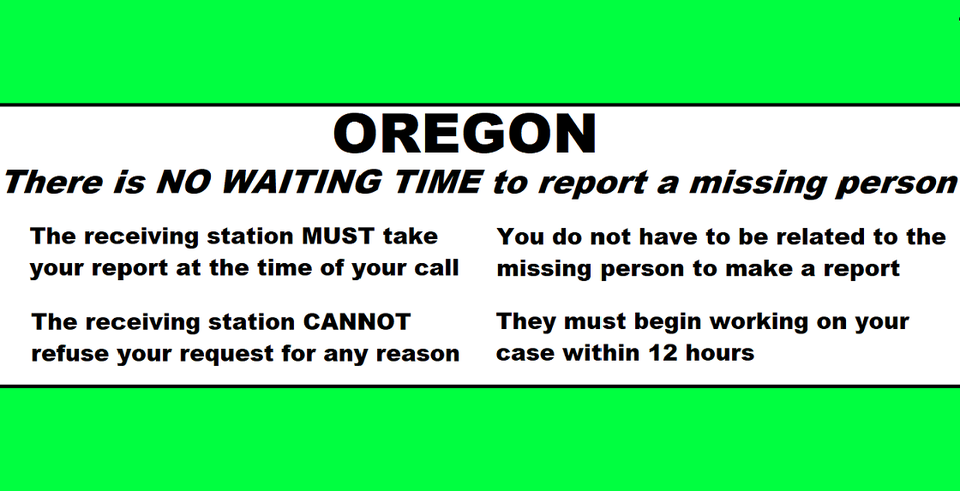
In Oregon we don’t have those rules and an officer or person answering the phone is not allowed to decide. The law decides. We have Senate Bill 351 and it states that the police CANNOT refuse a request for any reason and they must begin working on it within 12 hours. The person making the report does not have to be related to missing person either.
Here is SB 351 written by families of the missing here in Oregon in conjunction with Oregon law enforcement officers. This should be common knowledge, please make it this way. https://olis.oregonlegislature.gov/…/SB351/Introduced
Taking Another Look at What Happened to Fauna Frey
Fauna was grieving the recent death of her brother, Dallas, when she set off from Eugene in June of 2020 heading to Grants Pass on what her family believes was both a healing trip and a mission to deliver gifts, silver coins inherited from Dallas, to a few friends.
But somewhere between motel check-ins and checkouts, something went terribly wrong. Her Jeep was found months later. She was never seen again. http://bit.ly/4l63Dle

We will start resharing podcasts and articles. For starters here is a story from Danielle Denham that appeared in the June 29, 2025 edition of That Oregon Life. Ms Denham worked closely with us to insure that the facts she presented were accurate.
Check out the nine episodes of the podcast Nowhere to be Found, a comprehensive, in-depth, sensitive treatment of the details surrounding Fauna’s disappearance. Hear from Fauna’s father, John, and her friends. Posted in spring of 2022, Amanda Popineau shares Fauna’s journey and the mystery that surrounds it. Go to Nowhere to be Found Season Two: Episode One “Under A Half-Moon.” https://podcasts.apple.com/kg/podcast/s2e1-under-a-halfmoon/id1532686678?i=1000512098162
We want to remind people that Fauna’s father is offering a huge reward for information that brings Fauna home.
Please if you have any information no matter how big or small let us know by calling the anonymous tip line or emailing.
Tipline- 541-359-5638
Email – Helpfindfaunafrey@gmail.com
FOLLOW on FACEBOOK GROUP: https://www.facebook.com/groups/341658526970132
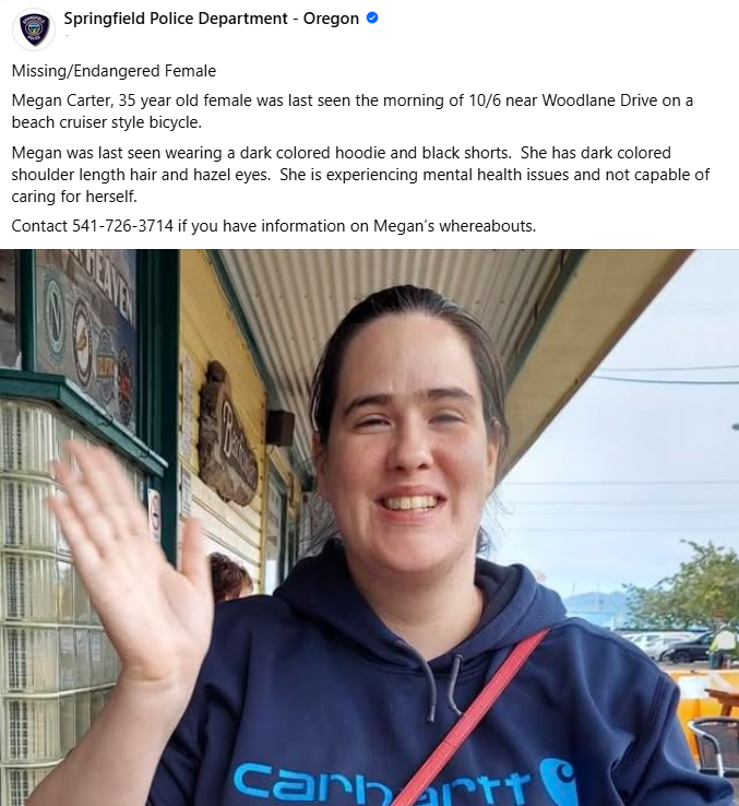
The Junction City Police Department is seeking the public’s assistance locating a missing and possibly endangered person.
62-year-old Wade Felton Lloyd, of Junction City, was reported missing on November 20, 2025. Mr. Lloyd was last seen on November 16th in the area of Birch Street and 2nd Avenue in Junction City.
Mr. Lloyd normally stays close to the Junction City area, has close ties to his family, and his only transportation is an older motorized bicycle, which is also missing.
Mr. Lloyd is a slender white male, standing 6 feet tall with brown hair and hazel eyes. Mr. Lloyd is without his cell phone, wallet, and his medications.
The Junction City Police have exhausted all leads as to his whereabouts and is hoping that the community might recognize him or recall where they last saw Mr. Lloyd. If you have information regarding Mr. Lloyd or have seen him on or after November 16th, 2025, please call the Junction City Police Department at 541-998-1245.
Find the mental health support you need

Click the pic to see all resources

