
The latest news stories and stories of interest in the Willamette Valley from the digital home of Southern Oregon, from Wynne Broadcasting’s WillametteValleyMagazine.com
Wednesday, August 4, 2021
Willamette Valley Weather
Today– Widespread haze. Sunny, with a high near 90. Light west northwest wind becoming north 5 to 10 mph in the morning.
Thursday– A slight chance of showers, with thunderstorms also possible after 8am. Mostly sunny, with a high near 82. West wind 3 to 8 mph. Chance of precipitation is 20%.
Friday– A 30 percent chance of rain, mainly before 11am. Partly sunny, with a high near 80. Calm wind becoming west around 6 mph in the afternoon.
Saturday– Sunny, with a high near 85.
Sunday– Mostly sunny, with a high near 81.
LOCAL HEADLINES:
State Land Use Board Stops EWEB’s Water Tank Project in SW Eugene’s Urban Forest
The state Land Use Board of Appeals (LUBA) granted a temporary halt on EWEB’s construction work related to the project to install two massive water storage tanks. Neighbors concerned about a large Eugene Water & Electric Board project in South Eugene have bought some more time with a last-minute appeal.
EWEB had felled more than 250 trees before state order halted the water reservoir project in SW Eugene’s Urban Forest.

The order will temporarily stop tree removal, which began at the site on Monday. Residents gathered near the site at East 40th Avenue and Patterson Street Tuesday morning to make sure crews did not cut down more trees.
According to the order, EWEB was issued an erosion prevention permit by the City of Eugene on Friday that paved the way for the project to move forward. EWEB had just begun work to build two, 7.5-million-gallon water tanks. But some residents started the process of appealing the permit, arguing it authorizes logging of a mature conifer forest.
LUBA then issued a temporary stay that specifically stops the destruction of trees. Sandra Bishop, a former EWEB commissioner who has spoken critically of the project, said she understands the need for drinking water storage but questions the size of the work.
“We’re saying yes, we need a reservoir: one reservoir,” Bishop said. “It’s a 10.74-acre site. One reservoir takes a little over an acre. Why is it that EWEB could not see clear to do one reservoir [and] save and preserve the forest and also save the oaks?”
EWEB officials are saying trees in the wooded area will still come down if the project moves forward. They also said the trees they cut down will be used for things like habitat restoration, creating more healthy oak habitats in the area.
The construction is scheduled to last until 2023 when the College Hill Reservoir needs to be put out of service. That tank provides roughly 80,000 people in Eugene with clean drinking water.
Officials for EWEB said pushback on the project was expected, but the longer the delay, the higher the cost of the project will be. The city has until Aug. 9 to respond to the order. http://www.eweb.org/community-and-environment/water-reliability-projects/water-storage-improvements/e-40th
Woman Burned But Escapes Mobile Home Fire Near Mohawk
A woman was burned in a mobile home fire near Mohawk Tuesday afternoon.
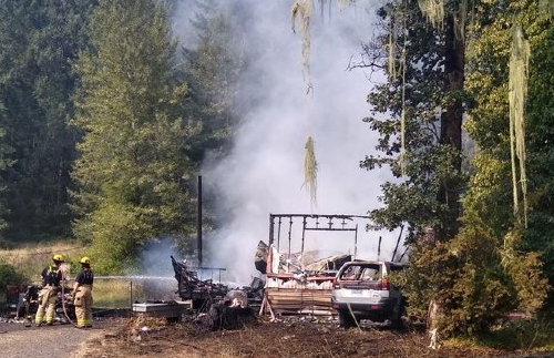
The fire sparked up in a double-wide mobile home in the 37200 block of Tree Farm Road in a wooded area. Crews scrambled to keep fire from spreading into the brush and trees.
While the woman was injured in the fire, she survived. Fire officials say the home is a total loss. It is under investigation.
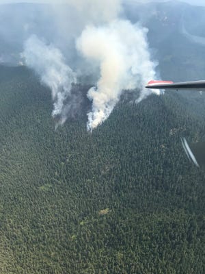
Middle Fork Complex Fires Grow
Officials state that The Middle Fork Complex fires near Oakridge grew more than 1,100 acres between Monday and Tuesday, reaching 1,707 acres total in size, according to the U.S. Forest Service. The complex is at 5% containment.
The Gales Creek Fire, the largest of the complex’s 12 fires, increased from 400 acres to 1,268 acres, with 0% containment as of Tuesday. It’s located south of Big Fall Creek Road (Forest Road 18) near Forest Road 1835.
Seven of the Middle Fork Complex’s smaller wildfires are at 100% containment. The fires were ignited by lightning and range from Fall Creek, Hills Creek Reservoir and north of Huckleberry. There are 463 personnel, five aircraft and 22 fire engines responding, according to a Tuesday morning Forest Service update.
Mark Thibideau, a public information officer for the Middle Fork Complex, said Tuesday any increase in fire acreage is a concern, adding that much of the Gales Creek Fire is on steep, rocky ground that is difficult for firefighters. “It’s super steep, there’s lots of opportunity for an injury, so they’re really taking their time and making sure they’re making the right decisions,” Thibideau said.
Heavy equipment will be used to remove vegetation along forest roads 1824 and 220 in response. The main priorities, Thibideau said, are to keep firefighters safe, while also keeping fires as small as possible and making direct and indirect containment lines. So far there has been one injury and no structures lost, he added.
Firefighters will focus on the Kwis Fire on Tuesday, Thibideau said, which has grown from 40 acres on Sunday to 204 acres. It’s located near Salmon Creek Road, roughly 5 miles east of Oakridge, the closest fire to the town.
“Fire crews are really honing in on that one today, and hope to make great progress there,” Thibideau said. “That’s based on the priorities or the values that would be at risk. It’s kind of a chess match almost where you have to put the right people in the right place to protect the most that we can.”
Of the other fires in the complex, firefighters are still battling the fire at Ninemile Creek, which is now 143 acres. Fire engines and crews will be working to establish a containment line along Forest Road 1834, which ties in with Road 339.
The 6-acre Elephant Rock Fire, which is approximately 2 miles to the southeast of the Gales fire, has held at 6 acres and is 0% contained.
The 78-acre Windfall Fire is now at 80% containment, located south of Cougar Reservoir, where crews will continue mop-up efforts.
The Devils Canyon, Packard, Way, Larison Cove, Warble, Journey and Symbol Rock fires range from 0.1 to 3 acres and are 100% contained.
Lane County issued a Level 3 — Go Now evacuation notice Sunday for all people living, camping and recreating along Big Fall Creek Road (Forest Road 18), east of the intersection with Forest Road 1821. That evacuation area includes Puma and Bedrock campgrounds. Evacuation information is available at www.lanecountyor.gov/cms/one.aspx?pageId=15883712.
The Forest Service issued an emergency area closure Monday within the area of the Middle Fork Complex, meaning all “roads, trails, developed recreation sites, dispersed camping, and entering of National Forest System” land in the closure area is prohibited. Here are the roads and recreation sites closed to the public:Your stories live here.Fuel your hometown passion and plug into the stories that define it.
- Roads: Forest Road 1802, Forest Road 1816, Forest Road 1817, Forest Road 1818, Forest Road 1821, Forest Road 1824, Forest Road 1825, Forest Road 1828, Forest Road 1830, Forest Road 1831, Forest Road 1832, Forest Road 1833, Forest Road 1834, Forest Road 1835, Forest Road 1839, Forest Road 1912.
- Campgrounds: Dolly Varden Campground, Big Pool Campground, Broken Bowl Campground, Clark Creek Organizational Camp, Bedrock Campground, Puma Campground.
- Trails and trailheads: Fall Creek Trail (closed by a separate Forest Closure Order), Clark Creek Nature Trail, Johnny Creek Nature Trail, Hehe Mountain Trailhead, Gold Point Trailhead, Saddle Blanket, Cowhorn Mountain, Tall Trees Trail, Jones Upper and Jones Lower trailheads, Jones Trail, Alpine Trail and Trailheads, Elk Camp Trailhead.
- Other recreation sites: Little Cowhorn Lookout, Timber Butte Lookout, Saddle Blanket Mountain.
Campfires are still prohibited on the entire Willamette National Forest due to very high fire danger and ongoing active fires.
New wildfires north of Detroit named ‘Janus Fire,’ grows to 300 acres in Bull of the Woods Wilderness
A total of four small wildfires and one large blaze have been identified in Mount Hood National Forest about 10 miles north of Detroit.
Three of the fires — the Janus, Kola and Ridge fires — are in the southeast corner of the Bull of the Woods Wilderness in the Janus Butte area.
The Janus Fire is the largest at an estimated 300 acres, up from 200 acres a day ago, while the remaining fires are each less than an acre.
Two other fires are outside the wilderness boundary near Round Lake.
Firefighters and two helicopters attacked the Round Lake fires on Tuesday and will continue working the blazes on Wednesday.
However, the wilderness fires will not be attacked directly due to inaccessible and dangerous terrain, fire spokeswoman Mary Ellen Fitzgerald said.
Given the shortage of resources and remote location, fire managers are planning to take “indirect tactics” on the wilderness fires — in other words, they’ll likely try to create control lines to keep the fires in the wilderness area but won’t hit the fire itself, expect possibly from the air.
Fitzgerald stressed that they do consider both wilderness fires to be “full suppression,” but given the nature of the fuels and location, the fire is likely to be around for a while and grow, she said.
“The first thing is that putting firefighters in there would be a high risk, and even if we did, the probability of success is not high,” she said. “We do want to keep it in the wilderness, but we just have to take a few steps back to do it.”
Fitzgerald said they’ve requested a large helicopter for water drops, but given the number of fires that have popped up following lightning strikes, resources are limited.
Fitzgerald acknowledged that the fires would conjure up memories of last summer’s Beachie Creek Fire, which also burned in a remote wilderness area where firefighters couldn’t attack it directly. The Beachie Creek Fire blew up on historic winds Labor Day night and helped fuel on of the biggest disasters in state history.
AROUND the STATE of OREGON
WILDFIRE UPDATES

This public lands link is super helpful to check before you head outdoors. The Keep Oregon Green website carries ODF’s public use restrictions. Click the link for up-to-date information:
https://keeporegongreen.org/current-conditions/
BOOTLEG FIRE:
A Red Flag Warning is in effect for this afternoon and evening. A Fire Weather Watch is in effect for Wednesday. A Red Flag Warning means that critical fire weather conditions are either occurring now or will shortly. Specifically, these conditions include continued warm temperatures, low humidity, and strong winds. Combined, they promote the rapid spread of wildfire and extreme fire behavior that could become life threatening
Size: 413,762 acres, 647 square miles – 51 miles active fire edge, 272 miles of contained line – Containment: 84%
Out of an abundance of caution and at the recommendation of the Alaska Incident Management Team, Lake County expanded the Level 1 (Get Ready) evacuation boundary to include the area north of Summer Lake. The expanded area extends from Mile Post 73 on Highway 31 north to Picture Rock Pass and east of the highway to include the Ana Subdivision. A Level 2 (Be Set) evacuation remains in place from milepost 73 on Highway 31 south to Monument Rock. A Level 3 (GO NOW!) evacuation remains in place for all areas within and adjacent to the Bootleg Fire perimeter, including Yamsay Mountain, Thompson Reservoir, and the Sycan Marsh to the top of Winter Rim.
The Bootleg Fire containment continues to advance as firefighting crews mop up, improve fire line, and strengthen contingency lines. Crews are working tirelessly to ensure we are as prepared as we can be for the extreme fire weather forecast for the next couple days.
Just as firefighters have been preparing for the weather conditions, you should, too. Fire starts are not just from escaped embers and lightning but can also come from a trailer chain dragged on pavement, a hot catalytic converter in contact with dry grasses, or shooting firearms. “Any accidental or negligent release of sparks or heat can result in a fire that quickly gets out of control,” says Kristian Knutson, Fire Prevention Officer in Palmer, Alaska, and incident Public Information Officer. “Be sure to remove combustibles from around the outside of your home, such as firewood, fuel tanks, and gas grills. Keep shrubs and tree limbs away from your house and off the ground.” At this time of year, one less spark could mean one less wildfire.
MIDDLE FORK COMPLEX:
Twelve individual fires make up the Middle Fork Complex, with seven fires at 100% containment. Four fires make up the northwest section of the Middle Fork complex. The Gales Creek Fire is located south of the Forest Road 18 near the 1835 road and is now 1,268-acres with 0% containment. Heavy equipment will be used to remove vegetation along the 1824 and 220 roads. The six-acre Elephant Rock Fire, which is approximately two miles to the southeast has held at six acres and is 0% contained. On the 143-acre Ninemile Fire, engines and crews will work along the 1834 Road tying in with 339 Road to obtain a solid containment line. With growth of the fire to the east- northeast, firefighters will evaluate containment opportunities. Crews will monitor and patrol the Journey and Symbol Rock Fires, each at 0.1 acre and both at 100% containment.
The 204-acre Kwis Fire is the closest fire to Oakridge and is located south of Forest Road 24 near Salmon Creek. Burnout will occur along established control lines to remove fuel between the fire and the control line. Hose lays are being established along control lines to aid with mop-up and increasing containment. The one-acre Warble Fire, which is 100% contained. Crews will patrol and secure line as needed.
South of Forest Road 19, the two-acre Devils Canyon Fire is 100% contained. Firefighters will continue mop-up and patrol in that area. Southwest of the Hill Creek Reservoir, crews secure solid line and plan to reach patrol and monitor status on the three-acre Packard Fire. That fire is 100% contained. The 78-acre Windfall Fire is now at 80% containment. Crews will continue mop-up efforts. Near the Hills Creek Reservoir, firefighters will patrol and monitor the Way and Larison Cove Fires, also at 100% containment.
SKYLINE RIDGE COMPLEX:
On August 1, 2021 at 5:00 p.m. a lightning storm over southern Douglas County ignited dozens of confirmed wildfires. Collectively, the fires have been dubbed the Skyline Ridge Complex. The fires range from less than an acre to over 600 acres and are burning on a mix of public and private forestland in southern Douglas County, east of Interstate 5. Firefighters from Douglas Forest Protective Association, Oregon Dept. of Forestry, Bureau of Land Management, and the US Forest Service have been aggressively attacking the blazes while providing for public and firefighter safety. The largest fires in the complex include Poole Creek (500-700 ac), O’Shea (100+ ac) and Ike’s Butte (40-60 ac).
Despite high temperatures and low humidity, crews are making progress—getting control lines built around the fires and working toward containment. The suppression strategy is to keep the small fires small and prevent them from turning into larger, more problematic incidents.
Oregon Department of Forestry’s Incident Management Team 1 assumed command of the fire at 6:00 p.m. on August 3, 2021. The Incident Management Team brings added capacity to manage firefighting efforts in multiple locations and the logistics of supporting the firefighters.
“We are happy to be here and lend the district some support,” said Joe Hessel, Incident Commander for ODF’s Incident Management Team 1. “Our goals are to keep these fires as small as possible while keeping everyone safe. Staying safe and healthy also means we’ll be following strict COVID-19 protocols,” said Hessel.
In addition to ODF’s Team taking command of the Skyline Complex, a separate incident management team (PNW Team 8) will be tackling the Devil’s Knob Complex which lies further to the east.
Level 1 “BE READY” Evacuation Advisory Issued for Skyline Ridge Complex
The Douglas County Sheriff’s Office has issued Level 1 “Be Ready” evacuation advisory as a result of fires burning within the Skyline Ridge Complex.
Fire Managers have notified the Sheriff’s Office that fires burning within the Skyline Ridge Complex are moving toward some residential areas on Upper Cow Creek Road. Based on this information, the Sheriff’s Office is instituting a Level 1 “Be Ready” advisory for the following residences:
- All homes on Upper Cow Creek Road with addresses starting at 11300 through 18299. This includes all side roads between these two points. For easier reference, the Level 1 “Be Ready” starts just above Galesville Dam and ends just beyond Red Apple Road where the Level 2 “Be Set” starts for the Wildcat Fire.

Level 1 “Be Ready” means: Residents should be aware of the danger that exists in their area, monitor emergency services websites and local media outlets for information. This is the time for preparation and precautionary movement of persons with special needs, mobile property and (under certain circumstances) pets and livestock. If conditions worsen, emergency services personnel may contact you via an emergency notification system.
Residents can opt in to receive emergency alerts based on their address by registering at www.dcso.com/alerts.
An interactive evacuation map can be found at www.dcso.com/evacuations where residents may enter their address to determine what level they may be in.
An incident specific Facebook page and an InciWeb site have been created for the Skyline Ridge Complex and information for the fires will be posted at these locations:
Facebook: www.facebook.com/skylineridgecomplex — InciWeb: https://inciweb.nwcg.gov/incident/7762/ — Douglas Co. Sheriff’s Office
JACK FIRE/ROUGH PATCH COMPLEX:
Firefighters spent much of Monday locating and combating new lightning starts in and around the Jack Fire and Rough Patch Complex and expect to continue today, fire officials said.“We had quite a day today very active, very busy with new starts,” said John Spencer, operations chief for Northwest Incident Management Team 13 under Brian Gales, which is now managing the Jack Fire, Rough Patch Complex and initial attack for new starts in the area. “There’s still more work to do and we expect more things to pop, but overall we had great successes.”
A morning reconnaissance flight identified 15 new lightning starts resulting from thunderstorms moving through the area Sunday evening. Fire crews began suppression efforts on six of those starts Monday and will begin addressing the remaining fires today. Four starts were successfully contained in and around the southern end of the Jack Fire (https://inciweb.nwcg.gov/incident/7605/) and work will continue today on three others.
Unsafe conditions created by standing dead trees and steep ground in the Copeland Creek drainage forced crews to disengage and identify strategies for addressing the eighth ignition, which they will implement today as well. Fire managers will be reassessing the overall objectives for the Jack Fire today due to the locations of these new starts. The fire footprint remains at 23,002. On the Rough Patch Complex (https://inciweb.nwcg.gov/incident/7758/), crews continued working along the 3821 Road and the 130 spur near Little Rock staging area to connect the southernmost containment line and preparing line along the 650 Road in the Chimney Rock area and the 3820 Road from the east.
The complex, located 26 miles east of Cottage Grove between Tiller and Glide, was designated July 29 to address multiple lightning starts. A total of 17 fires had burned about 429 acres as of Monday evening.
Fire managers are working with private landowners and timber companies to coordinate the removal of logging equipment and some log decks located within the complex and strategize protection measures for other stockpiles.
Warm weather will continue today and Wednesday, with temperatures in the upper 90s at low elevations (2500 ft.) and 80s at high elevations (4000 ft.). Relative humidity will be in the teens with a 10 percent chance of thunderstorms. Thursday, winds will range from about 6 to 8 mph out of the southeast, with gusts around 13 mph.
ELBOW CREEK FIRE:
Due to the reduced complexity of the Elbow Creek Fire, Oregon Department of Forestry’s Type 1 Incident Management Team 3 will hand the fire over to a smaller Type 3 organization tomorrow morning. The team would like to again thank the communities in the area for their kind hospitality and support during our stay.
The forward spread of the fire has been stopped for several days and stands at 22,960 acres and 95% contained.
The Type 3 organization will be working for the Umatilla and Wallowa-Whitman National Forests, the Vale District of the BLM and the Northeast Oregon District of the Oregon Department of Forestry.
The main responsibility of the new team will be to complete any remaining mop-up, patrol the perimeter, backhaul fire cache supply such as hose, pumps and portable water tanks, and continue suppression repair work.
The fire camp located at the Stampede Grounds in Elgin will be shut down. All personnel working the south end of the fire will be working out of the main fire camp located about three miles up Promise Road from Highway 82. A spike camp for crews working on the north end of the fire will be located on the 62 road at Fry Meadow Seed Orchard.
Resources working under the team will include eight 20-person crews, nine engines, four water tenders, four dozers and 2 excavators.
Information sources will remain in place for the Elbow Creek Fire, including Facebook and Inciweb. News updates about the fire will be provided as needed. Additional information can be obtained by calling (541) 805-2784 Monday through Friday 8:00 a.m. to 5:00 p.m.
WILDCAT FIRE:
The Douglas County Sheriff’s Office has upgraded evacuation notices due to the Wildcat Fire.
The fire is moving toward some residential areas near Upper Cow Creek Road, which is why some are asked to evacuate now. Below are the current evacuation notices:
LEVEL 3 GO
- All homes on Upper Cow Creek Road with addresses from 20039 to 20700.
Level 3 Go means leave immediately as danger is imminent.
LEVEL 2 BE SET
- All homes on Upper Cow Creek Road with addresses from 18300 to 20000.
Level 2 Be Set means residents should be prepared to leave at a moment’s notice as there is significant danger in the area. Residents can choose to find a place to stay or gather necessary belongings in case the evacuation notice is upgraded.
Residents can opt-in to receive emergency alerts based on their address by registering HERE
An interactive evacuation map can be found HERE
Oregon to Receive Nearly $35 Million In Federal Grants For Wildfire Recovery
Oregon’s U.S. Senators Jeff Merkley and Ron Wyden have announced that nearly $35 million in federal grant funding is headed to five counties in Oregon, including Douglas, to help cover the cost of wildfire debris removal efforts.
Merkley said when the Labor Day fires hit last year, he criss-crossed the state to meet with impacted communities and assess the damage. Merkley said, “It’s impossible to put into words how heartbreaking it is to see the rubble of cherished homes and businesses that got caught in the flames, and it takes real courage to clean up the debris and start anew”. Merkley said he will continue to do all he can to help Oregonians get back on their feet, “…while also addressing the climate chaos that is causing these catastrophic wildfires in the first place”.
Wyden said, “The devastating losses from last year’s fires throughout our state came through in painful and powerful detail from Oregonians who both showed and told me how these blazes destroyed their homes, businesses and communities”. Wyden said one common theme in Oregonian’s work toward a full recovery and rebound “…is the urgent need to cover the often-punishing costs of removing debris from that destruction”.
Douglas County will receive over $2 million of the funds, to remove debris from 65 homes and structures throughout the county that were destroyed by the Archie Creek Fire. The other counties receiving help include:
*Nearly $12 million for Marion County
*Over $10 million for Jackson County
*Nearly $7 million for Lane County
*Over $3,5 million for Lincoln County
COVID UPDATE:

Oregon reports 1,575 new confirmed and presumptive COVID-19 cases, 9 new deaths
There are nine new COVID-19 related deaths in Oregon, raising the state’s death toll to 2,872, the Oregon Health Authority reported at 12:01 a.m. today.
Oregon Health Authority reported 1,575 new confirmed and presumptive cases of COVID-19 as of 12:01 a.m. today, bringing the state total to 223,364.
The new confirmed and presumptive COVID-19 cases reported today are in the following counties: Baker (21), Benton (21), Clackamas (96), Clatsop (19), Columbia (16), Coos (35), Crook (22), Curry (32), Deschutes (42), Douglas (83), Grant (2), Harney (2), Hood River (6), Jackson (253), Jefferson (4), Josephine (41), Klamath (27), Lane (127), Lincoln (11), Linn (43), Malheur (25), Marion (164), Morrow (5), Multnomah (116), Polk (39), Tillamook (9), Umatilla (96), Union (11), Wallowa (6), Wasco (11), Washington (160), Wheeler (4) and Yamhill (26).
Lane County reports 135 additional COVID-19 cases, no new deaths.
Klamath Basin Growers To Get $15 Million Toward Drought Relief
Klamath Basin farmers will have another opportunity to seek aid funding to offset their losses from the current water shortage. The U.S. Department of Agriculture announced Monday that it would invest $15 million into a program that will assist growers in the drought-stricken region.

USDA referenced the closure of the Klamath Project’s “A” Canal, which means that no water from Upper Klamath Lake will go toward irrigation this year. The new block grant allows for payments to producers who agree to reduce their irrigation demand. That water then can be used for other means.
“As ongoing drought conditions in the West continue to worsen, we need to find ways to do things differently in order to provide help and assistance to producers, Tribes, and communities,” said Gloria Montaño Greene, USDA’s Deputy Under Secretary for Farm Production and Conservation. “We recognize that current USDA programs and services are not enough to meet this historic challenge, and this pilot will help us find more tools to add to our toolbox.”
The block grant will go to the Klamath Project Drought Response Agency for distribution to producers. According to KPDRA president Marc Staunton, the organization is still working out the details of how the funds will be deployed. It may be distributed out to producers on all eligible land within the Klamath Project on a per-acre basis, though some land does not qualify.
“Unfortunately, the same as for our ‘non-irrigation’ program, land will not be eligible in districts that the Bureau of Reclamation believes is not in compliance with the 2021 Project operations plan,’ said Mr. Staunton.
The Klamath Water Users Association, which represents the interests of Klamath Project growers, said that this new grant replaces a $10 million program announced in April. There is also a $15 million Bureau of Reclamation program in effect, but KWUA says that together the two programs are “still not nearly enough.”
“Our most important priority is to have water for irrigation so producers can produce,” said KWUA executive director Paul Simmons. “But we have to play the cards we were dealt this year and do the best we can for producers who are under duress.”
Governor Kate Brown also released a statement on Monday applauding the program:
“The Klamath Basin is facing historic challenges from drought conditions that are creating hardships for the people, farms, ranches, communities, and ecosystems of the region. Today’s announcement from the U.S. Department of Agriculture is a great step to help agricultural producers in the region. I appreciate the partnership of Secretary Vilsack and the Biden-Harris administration in helping to relieve hardship in the region, both through this new pilot and ongoing programs.
“What is clear is that, because of the ongoing impacts of climate change on the region, the Klamath Basin will continue to face too many demands for a limited and decreasing supply of water. We must continue to work towards a long-term drought solution for the region, and today’s relief efforts are a down payment toward that goal.”
‘Operation Ship Shape’ Targets Lapsed Motorboat Registrations Around the State
The Oregon State Marine Board will be partnering with 32 county sheriff’s offices and the Oregon State Police, looking for expired motorboat boat registrations as part of a targeted annual “Operation Ship Shape” exercise, Aug. 7-8.
If you own a motorboat in Oregon, it’s time to check your “OR” numbers on the front of your boat (bow) and make sure you’ve applied your current registration decals. The OR numbers are a boat’s license plate, and registration decals are the tags that tell marine officers if your boat is legally registered and to whom it belongs, similar to motor vehicles. Registrations are valid for two calendar years.

“Oregon’s recreational boating infrastructure is funded entirely by boaters, so it’s really important for every boater out there to be currently registered,” Randy Henry, boating safety program manager for the Marine Board, said. “On Aug. 7 and 8, we’re checking everyone whose decals are expired or numbers are unreadable.”
The Marine Board is funded by registration, title fees, and marine fuel taxes paid by motorized boaters. No lottery, general fund tax dollars, or local facility parking fees are used to fund agency programs. These fees go back to boaters in the form of boat ramps, docks, trailered parking spaces, restrooms, construction and maintenance, and for boating safety marine law enforcement services.
“Any boat that is powered by a motor — electric, gas, diesel, or steam — and all sailboats 12 feet and longer must be currently registered when on the water, even when docked or moored,” Henry said.
This includes drift boats, inflatable rafts, stand-up paddleboards, or float tubes with an electric motor.
Henry added, “Each boat registration brings in additional funds from motorboat fuel tax and federal boating dollars. Registering a 16-foot boat provides $100.20 of funding, but results in additional matching funds of nearly $190, so this registration fee results in $267 of revenue available to fund facilities and marine enforcement.”
Henry reminds boaters that, if they’ve just purchased their boat or are in the process of registering it, they should be sure to carry the temporary registration and present it to marine officers, just like vehicle registration.
Boaters can renew their motorboat registration online or by visiting their local registration agent. Boaters can print a temporary permit after successfully completing their transaction online. A registration agent will issue a temporary permit for an additional fee. If you need assistance renewing online, please contact the Marine Board at marine.board@oregon.gov or 503-378-8587.