
The latest news stories and stories of interest in the Willamette Valley from the digital home of Southern Oregon, from Wynne Broadcasting’s WillametteValleyMagazine.com
Wednesday, July 24, 2024
Willamette Valley Weather
“This latest round of weather is extremely concerning,” Oregon State Fire Marshal Mariana Ruiz-Temple said in a statement Sunday. “Our firefighters are doing everything thing they can to rise to this immense challenge, but they are taxed, and we need our fellow Oregonians’ help. Please take precautions to avoid sparking a human-caused fire, be familiar with evacuation levels, and have a go-kit ready in case you need to leave your home.”
Fire Weather Tools from the National Weather Service
As we prepare for the peak of wildfire season in the U.S., the National Weather Service (NWS) reminds wildland fire managers that we have tools to help you monitor and fight wildfires. Whether it is a prescribed burn, ground fire or crown fire, fire managers can use this information to make decisions on how best to combat fires and keep the public safe.
Fire weather forecasters – The NWS issues Fire Weather Outlooks for the next eight days. These outlooks show areas where pre-existing fuel conditions, combined with forecast weather conditions, may result in a significant threat of wildfires.
Our Fire Weather Program supports land managers and firefighters who mitigate and respond to fires. Our weather forecasts are designed to highlight times and locations where a fire may be exceptionally hard to control. For example, we offer Red Flag Warnings, which mean warm temperatures, very low humidities and stronger winds are ongoing or expected to produce an increased risk of fire danger in 12 to 24 hours for specific locations.
Need a fire weather Spot Forecast? Land managers can request a site-specific, localized forecast for prescribed burns and wildfires to assess a potential threat. NWS recently updated this tool and will deliver additional enhancements to the application later this year. Learn more about the new Spot Forecast tool.
For federal and select state large wildfires, onsite weather forecasting support to firefighters is critical. An NWS Incident- Meteorologist (IMET) can be deployed to your incident command post. IMETs arrive on scene within 12 to 24 hours after activation and can serve up to 14 consecutive days before being relieved by another IMET. https://www.weather.gov/news/241507-fire-weather-tools
PLEASE Help Prevent Human-Caused Wildfires
- Immediately call 911 to report fires.
- Drones and other unmanned aircrafts are illegal to fly near fires.
- Fireworks, incendiary/tracer ammunition and exploding targets, are prohibited during fire season (May-October).
- Use caution when target shooting. Clear a 20-foot radius around the target by removing all vegetation and rocks.
- Ensure vehicles and trailers are properly maintained
- Make sure chains and other metal parts are not dragging.
- Keep exhaust systems clean and use spark arrestors.
- Do not park on dry grass.
- Carry extra water, shovel, and/or a fire extinguisher with you.
- Ensure your campfire is completely extinguished before leaving your campsite by making sure it is cool to the touch.
- Please don’t smoke and if you do, don’t throw out cigarette butts.
- Please be mindful and think about your actions
To ensure all Oregonians remain safe during the 2024 wildfire season, we urge everyone to stay tuned into these communications channels and follow all official safety guidelines related to air quality and recreation:
Watch Duty app: Download this app on your smartphone to understand where wildfires are in real time as well as monitor air quality and other metrics. https://app.watchduty.org
Northwest Interagency Coordination Center: During fire season, this web-based interactive map is updated daily with current fire perimeters and locations. This website acts as the wildfire resource coordination center for the Bureau of Land Management, US Forest Service, Oregon Dept of Forestry, US Fish and Wildlife Service, Bureau of Indian Affairs, Washington Dept. of Natural Resources and the National Park Service. https://gacc.nifc.gov/nwcc/index.aspx
InciWeb the Incident Information System: The federal interagency all-risk incident information management system provides an interactive map with real-time location information on wildfires. https://inciweb.nwcg.gov/
Oregon Department of Forestry Wildfire News: The official wildfire news blog for the Oregon Department of Forestry. Look here for all wildfire news related to state forest lands. https://odffire.com/
Keep Oregon Green: A partnership comprised of statewide and interagency groups working together to promote awareness of the risk and causes of wildfires and how to be prepared in case of a wildfire emergency. https://keeporegongreen.org/
OregonLive Wildfire Map: A project managed by OregonLive that incorporates data from InciWeb, National Interagency Fire Center, Northwest Interagency Coordination Center, Oregon Office of Emergency Management, NOAA into an easy-to-use map tool. https://projects.oregonlive.com/wildfires/map
Oregon Department of Environmental Quality – Air Quality Monitoring Data: A real-time map and cell phone application you can use to track air quality, including wildfire smoke impacts, across the state. Check your app store for OregonAir. https://oraqi.deq.state.or.us/home/map
Purple Air – Air Quality Map System: Real-time air quality information using crowdsourced data and data from EPA air sensors. https://map.purpleair.com/1/mAQI/a10/p604800/cC0…
NOAA High Resolution Rapid Refresh Data Visualization: The High-Resolution Rapid Refresh (HRRR) from the National Oceanic and Atmospheric Agency(NOAA) is an experimental data visualization tool for wildfire smoke. Be sure to turn on the “Vertically Integrated Smoke” layer to see smoke paths. https://hwp-viz.gsd.esrl.noaa.gov/smoke/index.html


Clay Walker takes the stage tonight as the fair kicks off and runs through the weekend.


Its Grange Day at the Fair! Kiddos 10 and under get in FREE if they bring in a dressed up fruit/veggie from 11am-1pm!
NEW Security protocol for 2024:
This year in order to provide an added level of safety for all Fair attendees we will be working with multiple law enforcement agencies and security personnel. In addition we have added metal detectors at the gates. This is part of our commitment to providing a safe and secure environment for all our fairgoers. We appreciate your cooperation as we work to ensure the well-being of everyone attending the Lane County Fair. Our goal is to have attendees enjoy an improve sense of safety without spending an extended period of time at the gate.

MORE INFO: https://www.atthefair.com and Follow on Facebook: https://www.facebook.com/LaneCountyFair
Eugene Police and Lane County Sheriff’s Office partner on strong fair security measures
The Lane County Fair is July 24 through to 28. To make the venue safer and a welcoming space for families, this year the Eugene Police Department and the Lane County Sheriff’s Office have partnered on strong security measures. Some changes to this year’s security include the addition of metal detectors at the entrances to the fair, increased and enhanced law enforcement presence throughout the fair and parking lots, and the addition of overlapping shifts of officers and deputies during the peak fair times. All these safety measures are in addition to private security hired for the fair.
According to EPD Chief Chris Skinner, “County fairs across America provide opportunities for friends and families to come together and enjoy the offerings of their unique area. It’s important to us as a police department to provide a safe and secure place for that enjoyment. If you plan on coming to the fair and engage in unsafe behavior, stay home.”
“For over a century, the Lane County Fair has been a cherished tradition in our community,” said Sheriff Cliff Harrold. “This year, we are proud to collaborate with the fair and other agencies to ensure a fun and safe environment where families can come together, create lasting memories, and celebrate our county. Let’s all work together to keep the fair enjoyable for everyone.”
The Lane County Fair, at 796 W. 13th Avenue, is a summer event everyone looks forward to. It is fun for all ages. The security measures are designed to make the venue safer so people can enjoy the many rides, games, exhibits, and entertainment.
Fire Updates
The High Prairie Fire is contained! The Chalk Fire information has been released at now 600 acres. The High Prairie area remains at a LEVEL 1The main focus today for USFS crews was maintaining the containment line. Minimal growth from the main fire at this point to the south towards Oakridge and Westfir.
They made good progress in working the southern edge of that containment line and tying it into the dozer line and road systems on the Huckleberry flats. More work remains tomorrow to secure the area tomorrow but excellent work on the fire today! USFS will have fire crew overnight to maintain awareness and protect the 1920 on the west side of the 19 road.


** 𝐌𝐭. 𝐏𝐢𝐬𝐠𝐚𝐡 𝐍𝐨𝐫𝐭𝐡 𝐁𝐨𝐭𝐭𝐨𝐦𝐥𝐚𝐧𝐝𝐬 𝐀𝐥𝐞𝐫𝐭 **Lane County Animal Services is using the arena located in the park to shelter livestock and other large animals that have been evacuated from the Oakridge area.

While the shelter is in place, it is important that regular park users give the livestock plenty of space – especially if they have dogs. Please leave a wide buffer between people with dogs and the shelter. We want all of the animals (and the people caring for them!) to be safe. Thank you for understanding as we put the park to a new, emergency use. Information about shelter and the High Prairie Fire can be found at www.LaneCountyOR.gov/HighPrairieFire

Eugene’s National Night Out is back at the ballgame on July 28!

Join us outside PK Park at 3 p.m. for a free, fun, family-centric community celebration. Meet your favorite K9s and special teams from Eugene, Springfield, UOPD, Eugene/Springfield Fire, and Oregon State Police. Enjoy displays from SWAT, Traffic Team, Bomb Team, K9, Drone Teams, Forensics, Animal Services, and more!Stay for the Monarcas vs. Spokane game at 5 p.m. and celebrate our community partnerships between innings.
Lane County Sheriff’s Office Still Seeking Suspect in Homicide

In June, a deceased female was located in the Cottage Grove area who appeared to be the victim of homicide. Lane County Sheriff’s detectives identified the victim as a missing person, Rozaleena Faith Rasmussen, 29, from Cottage Grove.
Detectives identified the suspect as Anthony Wesley Tyrrell, 31, of Cottage Grove. A nationwide warrant has been issued for his arrest. Tyrrell is described as a white male adult with brown hair, brown eyes, weighing approximately 165 pounds and standing approximately 5’9” tall. He was last seen with his head shaved and wearing a white shirt, black trench coat, black pants, and black boots.
Tyrrell is considered armed and dangerous. Anyone with information about his whereabouts is asked to call 911 and avoid approaching or contacting him.

Applications are being sought until August 14 for this year’s mural project
with four artists selected who will be paid $1,500 each.
The selected artists will paint their murals on September 19 and 20 at four storm drains in the Thurston area of east Springfield.
“When It Hits The Fan”: A New Podcast by Lane County Emergency Management
Lane County Emergency Management is excited to announce the launch of a new podcast, “When It Hits The Fan,” now available on all major podcast platforms including Apple Podcasts and Spotify.

“When It Hits The Fan” is designed to equip listeners with essential knowledge and resources to be prepared and stay safe during a disaster. Whether you’re new to emergency preparedness or a seasoned prepper, the podcast offers can help you face the future with confidence.
“Our goal with ‘When It Hits The Fan’ is to reach community members in a format that’s accessible and engaging,” said Lane County Emergency Manager Tiffany Brown. “We want to provide digestible and actionable information that people can easily incorporate into their daily lives to ensure they are prepared for any emergency. We hope to foster a culture of preparedness and resilience within our community.”
Episodes are share monthly and, so far, include:
- “Welcome! And, what the heck is emergency management?” – An introduction to the world of emergency management.
- “What do you mean we should be two-weeks ready?!” – Practical tips for ensuring your household is prepared for emergencies.
Listen at www.LaneCountyOR.gov/fan.
About Lane County Emergency Management – Lane County Emergency Management is committed to preparing the community for emergencies and disasters through education, planning, and response coordination.


If you are taking a young child to a big event, local Fairs, Six Flags, theme park, Fenway Park or any other busy location … Write your phone number on their wrist and cover it with liquid band aid in case you get separated. Also, take a photo of them using your cell phone the morning of the event so you have their clothing, hair style and up to date photo. Just in case they get lost. Stay safe this summer! #BePrepared#TipofTheDay

Oregon Department of Transportation – If you plan to travel across the state in the coming days, make sure you carefully plan your route.

I-84 and many other highways in #EasternOR may be closed or unreliable due to wildfires. Visit TripCheck.com for the latest closure points and details.
Due to current fire activity, we expect continued and/or more I-84 closures. Do not rely on this route in the upcoming days. Many other eastern Oregon highways are also closed or impacted as well.
Wildfires are unpredictable and we have no estimate on opening times for any fire-impacted highways. Previous plans for a nighttime only closure of I-84 to remove brush along the highway were upended when the wildfire quickly reached the interstate. Fire crews are actively fighting fire from I-84.Travelers should use U.S. 20 to move east or west across central and eastern Oregon during this current period of fire activity. If you must travel, consult TripCheck.com and check real-time conditions for your ENTIRE route.
Tips while traveling in #ORfire season:
1. Don’t blindly follow GPS directions or detour on local or forest roads. These roads are not suitable for interstate traffic. If a highway is closed on TripCheck, it is likely that nearby local roads are also closed due to wildfire in the area. TripCheck is updated 24/7 by dispatch staff.
2. Expect power outages near wildfires. Treat non-working traffic lights like a four-way stop. Roadside message boards and TripCheck cameras may also be out in these areas.
3. Carry extra supplies including food, water, necessary medications, etc. for all your passengers, including pets.
4. Driving in smoke is like driving in heavy fog. Slow down but keep a steady pace and stay alert. Slow driving gives you more time to respond to unexpected conditions. Turn on headlights when driving in smoky areas.
5. The best place to wait for a highway to reopen is at home. Do not travel to the closure points and wait, closures could last for days. Find fire information, including a fire overview and map, smoke forecast and sign up for local emergency alerts by visiting wildfire.oregon.gov
Oregon Department of Emergency ManagementOregon State PoliceOregon Department of ForestryOregon State Fire Marshal
Campfires temporarily banned at most Oregon State Parks due to dry conditions, nearby wildfires

— Oregon Parks and Recreation Department (OPRD) temporarily banned campfires at most Oregon State Parks due to dry conditions and the strain on firefighting resources from wildfires burning across the state.
Campfires and open flames are banned at all parks east of the Cascades due to the low humidity and risk of wildfires. They’re also restricted at parks in high-risk areas across the state until conditions improve. Most bans impact parks east of the Cascades and in the valley with some restrictions at select coastal parks.
“We understand that campfires are an important part of the experience at Oregon State Parks. We don’t make the decision lightly to restrict the use of fire, but unfortunately conditions require that response. The decision is made in consultation with our local fire agencies. Thank you for helping us do our part to reduce the risk of any new wildfires,” said JR Collier, OPRD’s deputy of statewide operations.
Campfire restrictions generally ban all “open flame,” but often make exceptions for propane cooking as the flame is contained. Check individual park webpages for details on any restrictions before visiting. Restrictions are listed in alphabetical order in a feature story at stateparks.oregon.gov/ or on the individual park pages.
OPRD also encourages visitors to know before they go when it comes to the impact of wildfires across the state:
- Several parks have been closed due to wildfires including Battle Mountain Forest State Scenic Corridor, Farewell Bend State Recreation Area, East and West Hatfield Trailheads on the Columbia River Highway State Trail and Ukiah-Dale Forest State Scenic Corridor. Check park webpages at stateparks.oregon.gov/ and search by park.
- Some parks have reduced air quality due to wildfire smoke. Check DEQ’s website for air quality information at www.oregonsmoke.org/
- Several roads and highways have been closed due to wildfires. Please use TripCheck to learn about closures and alternative routes. Relying on GPS might lead drivers into unsafe conditions
For more information about current wildfires around the state, go to the Oregon Department of Forestry’s website: https://www.oregon.gov/odf/fire/pages/firestats.aspx.
For more information about wildfire prevention, please visit the Oregon State Fire Marshal’s webpage at https://www.oregon.gov/osfm/education/pages/prevent-wildfires.aspx.
Campfires prohibited across BLM’s Northwest Oregon District
– Starting July 23, campfires will be prohibited on all Bureau of Land Management public lands throughout the Northwest Oregon District. BLM leaders encourage all visitors to be aware of active restrictions and closures as hotter, drier weather sets in around the Pacific Northwest.
In addition to fires and campfires, the stronger restrictions also prohibit smoking in vegetated areas; using vehicles in unmanaged vegetated areas; operating a chainsaw; welding, cutting or grinding; or using an internal combustion engine without a spark arrestor. These prohibitions will stay in effect until rescinded.
These level II fire restrictions help reduce the risk of human-caused fires. They build on the BLM’s statewide fire restrictions prohibiting fireworks, exploding targets or metallic targets, steel component ammunition (core or jacket), tracer or incendiary devices, and sky lanterns, which went effect May 24.
Those who violate the prohibition may be fined up to $100,000 and/or imprisoned for up to 12 months. In addition, those found responsible for starting wildland fires on federal lands can be billed for the cost of fire suppression.
For the complete order and more information on seasonal fire restrictions and fire closures, please see www.blm.gov/orwafire.
To learn more about fire careers with BLM Oregon-Washington, please see https://www.blm.gov/programs/public-safety-and-fire/fire/state-info/oregon-washington/careers.
Oregon Investigators Offering Reward For Information Identifying Individuals Who Started The 134,000 Acre Cow Valley Fire
Most of the Country doesn’t know that Oregon is absolutely running rampant with wildfires. At least four wildfires are now over 100,000 acres in the state. The Durkee Fire broke 143,000 acres today, The Lone Rock Fire is 117,000 acres, The Falls Fire is 121,000 acres, and the Cow Valley Fire is 133,000 acres.
Fire investigators and law enforcement from multiple agencies put out a public notice asking the public for information leading to identifying individuals who may have started the Cow Valley Fire, The Bonita Road Fire, and others in the Malheur Reservoir area.
Fire managers and investigators say these fires started in a “suspicious manner.” These fires have already cost $10 million and had a massive resource allocation, putting added strain nationally on firefighting resources.
7 Structures were lost on the Cow Valley fire alone.
Reward offered for information relating to wildfires in the Malheur Reservoir area.
VALE, Ore. – Fire investigators and law enforcement officials are requesting the public’s assistance in the investigation of the Cow Valley, Bonita and other small wildfires in the Malheur Reservoir area.
These fires all began in the early morning hours of July 11, between approximately 1 and 5 a.m. They are believed to be human-caused and of a suspicious nature. A monetary reward is being offered for information leading to the identification of individuals responsible.
Anyone with information about any of these incidents should call We Tip Anonymous at 1-800-47-ARSON, online at wetip.com.
This is a multi-agency investigation by the Bureau of Land Management Vale District, Oregon State Fire Marshal, Malheur County Sheriff’s Office, and Oregon State Police.
Shortly after these and other fires broke out, the Pacific Northwest increased its wildfire preparedness to the highest level, a PL5. There are currently 28 uncontained large fires in the PNW, with 11 Teams assigned to these incidents. (SOURCE)
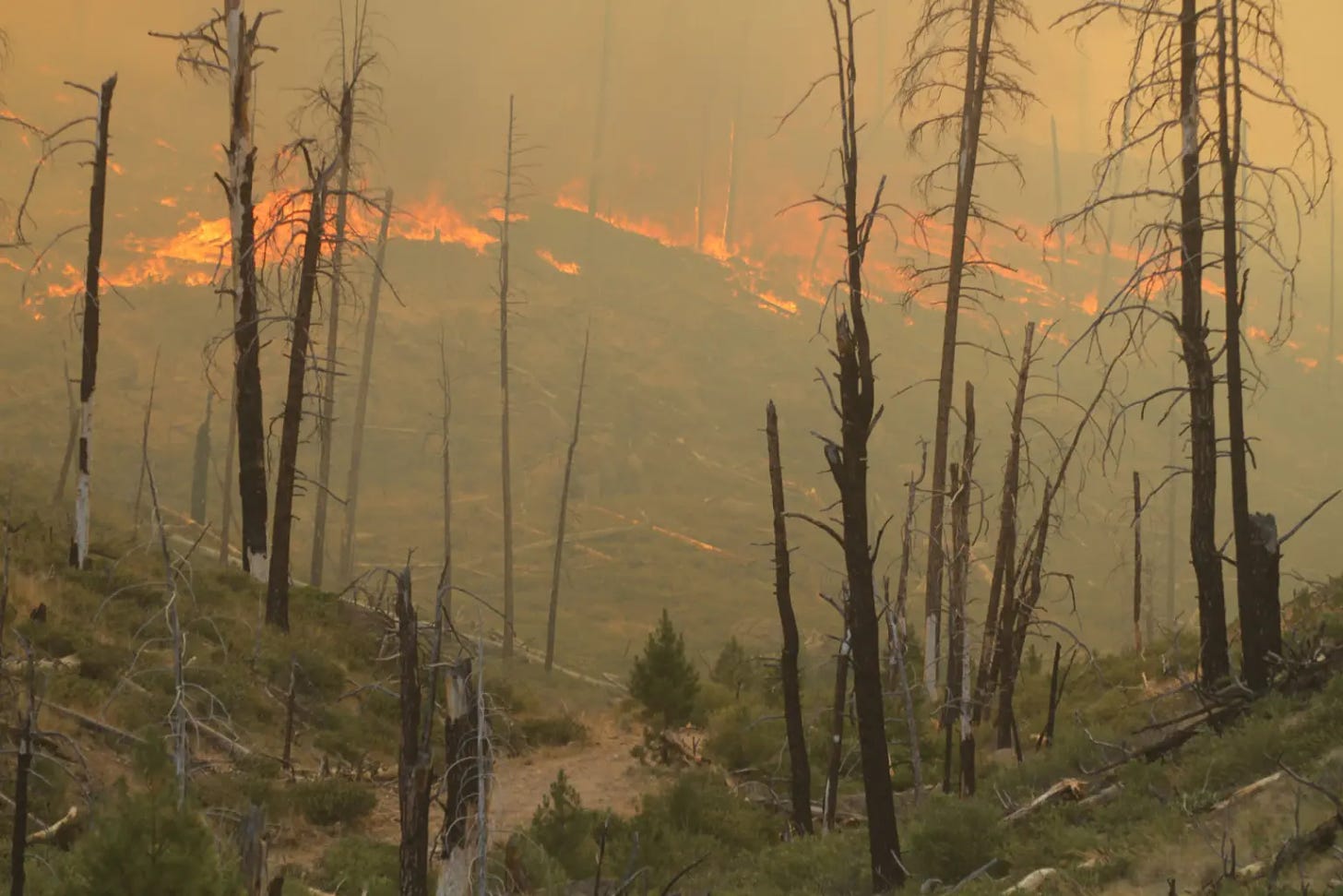
Elevated wildfire risk as Oregon wildfire season off to ‘aggressive start’
A spate of lightning storms coupled with hot dry weather has created high-risk wildfire conditions earlier than expected, officials said
Heat, lightning and wind have conspired to create high-risk conditions for wildfire across southern, central and eastern Oregon far earlier in the summer than state officials anticipated.
“We are fighting fire like it’s August 19, not July 19,” said Mariana Ruiz-Temple, Oregon’s state fire marshal, at a news conference Friday. The wildfire season in the Northwest can last from May through October, but typically the season is most intense from July to September.
As of Friday afternoon, there were 24 large fires of 100 or more acres burning in parts of Oregon, according to the Northwest Interagency Coordination Center, a wildfire prevention and response network that includes nine state and federal agencies across the West.
Northwest Large Fire Interactive Map displays where fires are currently burning in Oregon. (Northwest Interagency Coordination Center)
In just the last week, Gov. Tina Kotek declared five conflagrations – meaning many structures have burned or the scale of the fires exceed local resources. They’re the result of some human-caused fires and thousands of lightning strikes earlier in the week that ignited more than 100 new fires.
Ruiz-Temple and the Oregon Department of Forestry’s deputy director of fire operations, Kyle Williams, said lightning storms that are expected Friday through Monday will further elevate risk. South central Oregon, in the Klamath and Medford areas are at highest risk Friday evening before lightning is expected to move north and east until Monday.
The two doubled down on their pleas to Oregonians to minimize the potential for human-caused wildfires so their agencies can manage scarce resources.
“We have our hands full already, and there’s more lightning coming – we can address that, as long as our resources are not busy dealing with other human caused fires,” Williams said.
So far, the number of human-caused wildfires in Oregon is below average, according to Williams. But because conditions are so hot and dry, those wildfires are getting larger and burning more acres than average.
Burn rules across state and national parks and forests have gone into effect, and fires are allowed only at some designated campsites. Officials recommend ensuring fires are properly doused and put out, that people keep vehicles off of dry grass and ensure vehicle chains are not dragging. The Oregon Department of Forestry recommends avoiding any backyard debris burning during the fire season.
Statewide emergency
On July 12, Kotek declared a statewide wildfire emergency, which enabled National Guard deployment to parts of the state and allowed state and federal resources to flow to areas in need.
“To be very honest, our wildfire season is off to a very aggressive start,” she said.
Oregon has received additional equipment and firefighters from Washington, California, New Mexico, Idaho, Montana, Oklahoma, Texas, Georgia, Colorado and Florida, and Kotek expects more wildfire fighters will arrive in the coming days.
“I cannot emphasize enough: This is a dynamic, fast-moving situation for our state, and we will continue to use every resource, every person that we can get our hands on, to fight these fires,” she said.For more information on how to prepare for possible evacuation, visit: wildfire.oregon.gov
Kotek could not provide details about whether or not the state would exceed its emergency wildfire budget, but indicated costs are adding up.
“I can say, it will be more expensive than the last fire season. I think that’s a safe bet,” she said.
Global issues with CrowdStrike security software taking down Microsoft systems has not impacted the agency’s work or any wildfire response work in Oregon, Kotek said.
Teams from the Oregon State Fire Marshal’s Office, Department of Forestry and the U.S. Forest Service and Bureau of Land Management are working together to protect property and natural resources. Erin McMahon, director of the Department of Emergency Management, said there have been 88 evacuation orders across the state so far this summer.
“Our firefighters are working at all hours of the day and night, in conditions that are hard for many of us to fathom,” Kotek said. “It’s going to be a long wildfire season, and we need each and every one of them.” (SOURCE)

| Incident | Type | State | Incident Size | UpdatedSort ascending |
|---|---|---|---|---|
| Oakridge Lightning Fires 2024 – ORWIF | Wildfire | Oregon | Acres | 3 minutes 26 seconds ago |
| Red Fire – ORDEF | Wildfire | Oregon | 262 Acres | 23 minutes 21 seconds ago |
| Boneyard Fire – OR95S | Wildfire | Oregon | 39646 Acres | 25 minutes 26 seconds ago |
| Diamond Complex – ORUPF | Wildfire | Oregon | 3352 Acres | 28 minutes 25 seconds ago |
| Durkee Fire – ORVAD | Wildfire | Oregon | 244842 Acres | 40 minutes 33 seconds ago |
| Lone Rock Fire – ORPRD | Wildfire | Oregon | 134752 Acres | 1 hour 2 minutes ago |
| Cow Valley Fire – ORVAD | Wildfire | Oregon | 133490 Acres | 9 hours 9 minutes ago |
| Battle Mountain Complex – OR97S | Wildfire | Oregon | 52832 Acres | 9 hours 32 minutes ago |
| Cottage Grove – Lane 1 – OR77S | Wildfire | Oregon | 1090 Acres | 10 hours 7 minutes ago |
| Homestead Complex – ORUPF | Wildfire | Oregon | 767 Acres | 10 hours 7 minutes ago |
| Ore Fire – ORWIF | Wildfire | Oregon | 747 Acres | 10 hours 12 minutes ago |
| Telephone Fire – ORMAF | Wildfire | Oregon | 5000 Acres | 11 hours 49 minutes ago |
| Whisky Creek Fire – ORMHF | Wildfire | Oregon | 155 Acres | 11 hours 49 minutes ago |
| Falls Fire – ORMAF | Wildfire | Oregon | 139507 Acres | 12 hours 2 minutes ago |
| Pyramid Fire – ORWIF | Wildfire | Oregon | 535 Acres | 12 hours 24 minutes ago |
| Microwave Tower – OR954S | Wildfire | Oregon | 150 Acres | 13 hours 33 minutes ago |
| Salt Creek – OR710S | Wildfire | Oregon | 4102 Acres | 1 day 15 hours ago |
| Larch Creek Fire – OR95S | Wildfire | Oregon | 18286 Acres | 4 days 9 hours ago |
| Little Yamsay Fire – ORFWF | Wildfire | Oregon | 6340 Acres | 1 month 3 weeks ago |
| 2023 Chilcoot Fire UNF – ORUPF | Wildfire | Oregon | 1940 Acres | 2 months ago |
| 2023 Chilcoot Fire UNF – ORUPF | Wildfire | Oregon | 1940 Acres | 2 months ago |
| 2023 Ridge Fire UNF – ORUPF | Wildfire | Oregon | 214 Acres | 2 months ago |
| 2023 Ridge Fire UNF – ORUPF | Wildfire | Oregon | 214 Acres | 2 months ago |
Large Fires in Oregon 7/24/24 7:30am per INCIWEB

Please Help Prevent Wildfires!

In these dry conditions, a single spark can cause a lot of damage. Learn how you can prevent wildfires by visiting the Oregon State Fire Marshal’s wildfire prevention page.

Climate change a growing public health threat in Oregon, but state adapting, report finds
The latest Climate and Health in Oregon report shows health impacts of heat, smoke and drought are rising, but some state investments are paying off
More Oregonians are suffering from respiratory, heart and mental health issues caused by extreme weather events linked to climate change, and rural, elderly and minority communities are being hit the hardest, a new state report found.

But new investments in portable air conditioners, home air filtration systems and gardens and green spaces are helping lessen the effects, according to the Oregon Health Authority’s latest Climate and Health in Oregon report.
Analyzing 2023, officials found that more people statewide than expected visited emergency rooms for respiratory illnesses and excessive heat effects and that people suffered mentally from natural disasters long after they occurred. The effect of poor air quality caused by wildfires was especially acute among the elderly, rural people and Oregonians of color. American Indians, Alaska Natives, Black residents, Native Hawaiians and Pacific Islanders were twice as likely to visit a health care facility for an air-quality related respiratory illness than the statewide average, according to the report.
But since the first annual report came out in 2020, as mandated by an executive order under former Gov. Kate Brown, the Legislature has invested in programs to help Oregonians adapt.
By 2030, the health authority aims to reduce smoke-related respiratory visits to emergency departments by 20%, heat-related hospitalizations by 60% and heat-related deaths by 70%.
To achieve the state targets, the 2023 Legislature allocated nearly $100 million to pay for climate adaptation and health resilience programs. This includes improving access to green spaces and healthy and sustainable foods and paying for home air filters and air conditioners. The health authority is also charged with educating the public about climate risks and modernizing health services to respond to climate challenges.
“Climate change poses a significant and growing threat to public health,” agency Director Sejal Hathi and Cara Biddlecom, the agency’s interim public health director, said in a letter in the report. “We can accept nothing less than building a public health system equipped, resourced and coordinated to prevent, mitigate and adapt to the health impacts of climate change.”
Smoke-related emergency room visits and hospitalizations for asthma are expected to add nearly $100 million to Oregon health care costs by the 2050s, according to the report.
Hottest year on record
Globally, 2023 was the hottest year on record, though Oregon was spared from exceptional wildfire events like those in 2020 and the excessive heat events like the summer “heat dome” in 2021, when temperatures reached triple digits from late June through mid-July. The Oregon Health Authority had not anticipated an event like that in the Portland metro area until 2050, the report said.
Between 2020 and 2023, 139 people died from heat-related causes in Oregon, including more than 100 in 2021. The toll over those years was three times that of the previous decade. Cardiovascular disease contributed to 25% of those deaths, and people 50 and older accounted for 87%, the report said.
It also looked at the lasting impacts of the 2020 wildfire season and 2021 heat dome.
The 2020 Labor Day fires burned more than 1 million acres, destroyed 5,000 homes, largely destroying the towns of Gates, Detroit, Phoenix and Talent, and left nine people dead.
Researchers found that mental health suffering, including uncontrollable worry, was acute among wildfire survivors years after the events. Officials said making communities resilient to climate change and adapting to heat and wildfire need to be baked into recovery and rebuilding efforts after such events.
The report said health authority officials are working on reaching people from different demographics in different parts of the state. Surveys have found that older Oregonians prefer to be alerted to upcoming extreme weather events through local television, while most other Oregonians prefer text messages. But more resources are needed, especially to help households obtain filters, emergency supplies for wildfires and upgraded doors and windows so they fully seal. (SOURCE)
Avangrid hires 5,000 sheep for grazing on two solar projects in the Pacific Northwest
Avangrid, member of the Iberdrola Group, has partnered with a fifth-generation Oregon rancher to graze sheep at two solar farms in Oregon and Washington, and launched likely the largest “solar grazing” operation in the region. Solar grazing is a vegetation management method used at solar energy facilities that uses grazing livestock, like sheep, instead of machinery. Sheep are effective at limiting the growth of weeds and vegetation, cutting down on wildfire risks while replacing the use of gas-powered machines.

Avangrid began this effort last year with a pilot project at Pachwáywit Fields, Oregon’s largest operating solar farm located in Gilliam County that serves Portland General Electric’s Green Future Impact participants. By the Spring, Avangrid expanded the pilot into a full solar grazing operation at Pachwáywit Fields. Avangrid also launched a similar operation at its Lund Hill solar farm in Klickitat County, Washington, the state’s largest operating solar facility. At the peak in the spring, there were more than 5,000 sheep spread across both facilities.
“Avangrid is one of the most sustainable companies in the world and this is yet another example of our hardworking teams taking an innovative approach to solving complex problems,” said Pedro Azagra, Avangrid CEO. “These sheep are not only a more environmentally friendly solution to manage the vegetation, but help us support the local community and contribute to a circular economy in the Pacific Northwest.”
The sheep at these sites belong to Cameron Krebs, a fifth generation Oregon rancher, who sells wool and lamb. Krebs and his family have partnered with Oregon-based Pendleton Woolen Mills for more than a century, providing wool fiber to the mill and clothing manufacturer.
“There has been a significant learning curve, but it is fascinating to watch the sheep learn to expertly move under and around the solar panels to eat the vegetation,” said Krebs. “They are consuming four to five pounds of dry matter per day. Another way to think about that is they are consuming four to five pounds of carbon and turning it into food and fiber, or returning it to the soil naturally. By reducing the total vegetation on site, we’re significantly reducing the fuel load and fire danger as we move into the hot, dry summer.”
“They are constantly eating,” said Dustin Ervin, Avangrid’s senior solar manager for Oregon and Washington. “The sheep maneuver around our solar panels better than the large mowing equipment we used in the past, and they eat right up to the panel arrays. We are proud to have taken this from concept to reality and I look forward to seeing how renewable energy companies begin to forge sustainable partnerships like what we’ve built with Cameron.”
“Creating world class products starts with healthy sheep providing the best wool possible,” said Keith Stonelake, wool buyer for Pendleton Woolen Mills. “The Krebs family has been one of our trusted wool growers for nearly 100 years and we are thrilled by the partnership between the Krebs’ and Avangrid.”
Avangrid will continue to utilize sheep at both Pachwáywit Fields and Lund Hill for the foreseeable future, managing the vegetation during peak growing seasons in the spring and fall. The Company is considering opportunities to expand solar grazing at other solar facilities within its portfolio. (SOURCE)
U.S. Senators Ron Wyden and Jeff Merkley and Representative Val Hoyle announced $16.6 million in federal funds for Oregon habitat restoration and coastal resilience projects have been made available through the Bipartisan Infrastructure Law and Inflation Reduction Act.
Wyden said, “Salmon, fishing and our beautiful outdoors are all central to Oregon’s economy and identity”. Wyden said, “This funding is exactly what I fought for in the Bipartisan Infrastructure Law and the Inflation Reduction Act, and I will continue to advocate for more resources to preserve Oregon’s pristine waterways and coast”.
Merkley said, “Oregon’s native fish are the lifeblood of our state, supporting the health and vitality of our communities, local economies, and Tribes who have been here since time immemorial”. Merkley said, “…Crucially, the two projects receiving funding will strengthen coastal resiliency and go a long way to enhance habitat for fish populations, including our beloved coho salmon, spring Chinook salmon and other native fish species”.
Hoyle said, “It will support better habitats for salmon on the Willamette River and the Oregon Coast. I’m looking forward to seeing the results of these investments, and I’ll continue working to bring federal funding back to Oregon”.
The joint release said the $16.6 million comes from the National Oceanic and Atmospheric Administration Fisheries’ Office of Habitat Restoration and will be used for:
*McKenzie Watershed Alliance – Resilience through Floodplain Restoration: Creating Conditions for Native Species and Communities to Thrive in the Upper Willamette: $8.5 million.
*Wild Salmon Center – Oregon Coast Coho Recovery Plan Implementation in Oregon: $8.1 million.
Opioid Settlement Board directs $13 million to substance use disorder treatment infrastructure
State Alcohol and Drug Policy Commission recommended allocation, which OHA will administer
PORTLAND, Ore. – A $13.08 million allocation by the Opioid Settlement Prevention, Treatment & Recovery Board (Settlement Board) will expand and strengthen the state’s access to substance use disorder treatment and services through opioid treatment programs (OTPs) and jails.
The Board approved Alcohol and Drug Policy Commission (ADPC) recommendations July 10. The allocation, which Oregon Health Authority (OHA) will administer, will improve access to medication for opioid use disorder and treatment services by providing:
- Up to $3.9 million to fund:
- Two mobile or non-mobile medication units in Clackamas County serving Oregon City and rural Clackamas County.
- An opioid treatment program or a mobile or non-mobile medication unit in Multnomah County serving the geographic areas of the county with the highest unmet need.
- Up to $9.1 million to fund a total of seven opioid treatment programs or mobile or non-mobile medication units, specifically:
- Two in Northeastern Oregon.
- One in the Mid-Gorge region.
- One in Klamath County.
- Two in underserved coastal areas.
- One in eastern Lane County.
To be eligible for funding, a mobile or non-mobile medication unit or an opioid treatment program must be currently certified by OHA.
- Up to $250,000 to Oregon Health & Science University (OHSU) to provide technical assistance to jails and to foster collaboration between opioid treatment providers and jails.
The funding was awarded to OHA, which will administer the allocations. The Board’s decision can be viewed in a recording of its July 10 meeting here.
Prior to awarding any funding, OHA must engage the partners listed in the ADPC proposal and provide a proposed timeline and implementation plan to the Board for approval no later than Sept. 1, 2024.
Since July 2021, the State of Oregon has reached agreement on national lawsuits against several companies for their role in the opioid crisis. Through these agreements, nearly $600 million will be awarded to Oregon over the course of 18 years. Settlement funds from opioid manufacturers, distributors and pharmacies are divided between the State of Oregon (45%) and local jurisdictions (55%).
The state’s share is deposited as it becomes available into the Opioid Settlement, Prevention, Treatment and Recovery (OSPTR) Fund. This fund is controlled by the 18-member OSPTR Board.
Local jurisdictions receiving settlement funds (those with populations greater than 10,000) decide how their funds are used. Cities and counties are required to report to the Oregon Department of Justice annually on how they have allocated their funds.
For state and local spending details from Fiscal Year 2022-2023, refer to the Oregon Opioid Settlement Spending Report: https://www.oregon.gov/oha/PH/PREVENTIONWELLNESS/SUBSTANCEUSE/OPIOIDS/Documents/opioid-settlement-report-fy-22-23.pdf.
The OSPTR Board will next consider additional investments in emerging issues. To learn more about Oregon’s opioid settlement funds, visit oregon.gov/opioidsettlement.
Oregon Wildlife Agencies Want Your Help Tracking Roadkill
This summer, the Oregon Department of Fish and Wildlife and the Oregon Zoo started asking Oregonians to do their own tracking and upload pictures of roadkill.

“The state wants to get a better idea about where different animals, different species are getting struck and killed by cars,” said Rachel Wheat, the ODFW wildlife connectivity coordinator.
If Oregon’s naturalists can identify roadkill hotspots, then maybe the state can reduce the number of animals killed in interactions with people each year by removing vegetation that attracts wildlife to a specific area or by building a wildlife crossing.
Roadways and vehicular traffic are a significant contributor to fragmentation of habitat and impacts to wildlife, including injury and mortality. The purpose of this project is to improve our understanding of the impacts of roads on Oregon’s wildlife, and to identify roadkill hot spots and vulnerabilities among a diversity of animals, including mammals, birds, reptiles, amphibians, and invertebrates. This information can help reduce wildlife-vehicle collisions and make roadways safer.
To sign up and for more information visit: https://www.inaturalist.org/projects/roadkills-of-oregon
Sens. Merkley and Wyden and Rep. Blumenauer urge VA to expand care to medical cannabis
They say that the prohibition deprives veterans of a drug that’s legal in nearly 40 states and forces them go to outside the VA system
U.S. Sen. Jeff Merkley wants veterans to receive access to medical cannabis through Veterans Affairs clinics and hospitals.
Merkley, D-Oregon, led a left-leaning independent and seven other Democratic senators, including Oregon’s U.S. Sen. Ron Wyden, in sending a letter late last week to Veterans Affairs Secretary Denis McDonough, urging him to allow medical marijuana treatment for veterans in states that have legalized its use. Medical cannabis is legal in nearly 40 states and the District of Columbia, but the federal government has not changed it alongside that trend.
The letter follows a similar plea in June spearheaded by another Democratic Oregon congressional member, Rep. Earl Blumenauer, co-chair of the Congressional Cannabis Caucus.
Oregon is home to 250,000 veterans and many rely on U.S. Department of Veterans Administration outpatient clinics in urban and rural communities and its hospitals in Portland and Roseburg. But a VA directive bars providers from recommending the use of medical marijuana or making referrals for its use. It even prevents providers from completing forms for state-authorized medical marijuana.
But advocates are hopeful the VA will loosen these restrictions following a May proposal by the U.S. Drug Enforcement Administration. It recommended that marijuana be rescheduled from Schedule 1 – the most restrictive listing possible for dangerous drugs with no recognized medical use – to Schedule III, which is less restrictive and recognizes the medical benefits of cannabis, potentially opening up treatment options.
The senators asked the VA to educate providers about the benefits of cannabis use to treat various medical conditions, including anxiety and seizures. They noted that scientific data shows it’s effective for controlling nausea and vomiting and stimulating the appetite while being much less addictive than opioids in treating pain.
“Leaving our nation’s heroes without access to effective pain management methods is unconscionable,” the letter said.
Blumenauer’s letter struck a similar tone, saying that barring medical marijuana forces veterans to seek outside care.
“No one is better qualified to make recommendations on care for veterans than veterans working with their VA health care providers,” Blumenauer wrote. “Placing arbitrary restrictions on those decisions is a disservice to our veterans.”
The letter was signed by a Republican, Rep. David Joyce of Ohio, and a Democrat, Rep. Barbara Lee of California.
In June, with a boost from Blumenauer, the House voted to 290-116 to pass an amendment to the VA’s spending bill that would end the agency’s prohibition on helping veterans access medical marijuana care. The bipartisan amendment, co-sponsored with U.S. Rep. Brian Mast, R-Florida, would require the agency to authorize providers to discuss medical marijuana with veterans and recommend that care if they believe it is necessary.
In 1998, Oregon voters approved legalizing medical marijuana. In 2014, Oregon voters legalized recreational marijuana.
Besides Merkley and Wyden, Democratic Sens. Kirsten Gillibrand of New York; Elizabeth Warren of Massachusetts; John Fetterman of Pennsylvania; Peter Welch of Vermont; Tina Smith of Minnesota; and Jacky Rosen of Nevada signed the letter along with Sen. Bernie Sanders, an independent from Vermont who caucuses with Democrats. (SOURCE)
Recently timeout.com listed the best parks in the United States and Oregon was the only state in the Northwest that made it to the top 10.

Even if you haven’t visited this park on the edge of the Oregon Coast, most likely, you’ve seen it on the big screen. This park, with an amazing outlook toward the Pacific Ocean, has been the backdrop in films including Twilight, The Goonies and Kindergarten Cop.
You’ll see information signs on them and other points of view extending to Haystack Rock, a sea slack in Canyon Beach, and the Tillamook Rock Lighthouse. Wander amid Sitka spruce forests and along a network of hiking trails, including the Clatsop Loop Trail, a two-and-a-half-mile-long historical loop. It partly follows the Corps of Discovery route, which is the Lewis and Clark Expedition military unit that trekked through the present-day park. Or spend time on the sand at Indian Beach. https://www.timeout.com/usa/things-to-do/best-state-parks-in-us
Bags of rice recalled in seven US states as they may contain ‘rodent parts’
Wehah Farms has issued a recall of 4,600 cases of its Lundberg Family Farms Sustainable Wild Blend Gourmet Rice in seven states . This is due to the potential presence of a “foreign object that appears to be of rodent origin.”

The US Food and Drug Administration (FDA) has classified this as a Class II risk recall, indicating that the product may cause temporary or medically reversible adverse health consequences.
The affected products are sold in 1lb bags with the lot code 231004 and a best-before date of October 4, 2024. The recall affects products sold in Arizona, California , Florida , Maine, New Hampshire, Oregon, and Wisconsin, according to Newsweek.
It remains unclear how the product became contaminated with rodent parts. FDA recalls are classified into three levels, with Class II being the second most serious type.
The FDA sets limits on the amount of “extraneous materials” that can be present in food, stating: “maximum levels for these defects in foods produced under current good manufacturing practice and uses these levels in deciding whether to recommend regulatory action.”
According to the FDA: “Extraneous materials include any foreign matter in a product associated with objectionable conditions or practices in production, storage, or distribution.”
They provide examples such as “Examples of filth may include any objectionable matter contributed by animal contamination such as rodent, insect, or bird matter; or any other objectionable matter contributed by unsanitary conditions.”
The FDA stated: “Some foods, even if they are produced in acceptable conditions, may contain natural or unavoidable defects that at low levels are not hazardous to health.”
One of Oregon’s most adorably iconic seabirds is coming to the front and back of a car near you. The Oregon Coast Aquarium has opened voucher sales for its new tufted puffin license plates.

The design, featuring a tufted puffin floating in the ocean and gazing down at some fish below, was created by the
aquarium’s graphic design and marketing coordinator, Cam Mullins.
Starring a tufted puffin—one of Oregon’s iconic seabirds–funds from the new license plate will benefit both the Aquarium’s animals and their wild counterparts. You can purchase a voucher now and exchange it at the DMV once the physical plates are available. We need to sell 3,000 vouchers to reach the production stage—meaning the sooner 3,000 vouchers are sold, the sooner production begins, and the sooner you’ll have your puffin plates in-hand. Read the full story at aquarium.org/puffin-plate-debut![]()
![]() : photo by OCAq’s Jeremy Burke
: photo by OCAq’s Jeremy Burke
Tufted puffins are native to Oregon and nest on the rocky coast. The aquarium has a Seabird Aviary that sustains a flock of these sea birds and the profits from the license plates will go to benefit these puffins and their wild counterparts.
The voucher is available for purchase on the aquarium’s website. The cost covers the $40 surcharge fee and the money left over after the deduction of the DMV’s fees will go to support the Oregon Coast Aquarium’s
rehabilitation and conservation efforts. The aquarium is building a new marine wildlife rehabilitation center with
hopes of doubling the number of animal patients it can offer care to. FOLLOW on FACEBOOK: https://www.facebook.com/OregonCoastAquarium

Oregon’s Missing Persons
Many times you’ll see postings without case numbers or police contact. There is rarely a nefarious reason why (the nefarious ones are pretty obvious). Usually the loved one tried to call to report their missing person and they are either refused or told to wait a day or two by people who are unaware of SB 351 and the laws that they are bound to when answering the phone. Many people don’t bother calling LE if their loved one is homeless or in transition because they believe LE won’t care. The biggest myth is the 24 hour rule.

In Oregon we don’t have those rules and an officer or person answering the phone is not allowed to decide. The law decides. We have Senate Bill 351 and it states that the police CANNOT refuse a request for any reason and they must begin working on it within 12 hours. The person making the report does not have to be related to missing person either.
Here is SB 351 written by families of the missing here in Oregon in conjunction with Oregon law enforcement officers. This should be common knowledge, please make it this way. https://olis.oregonlegislature.gov/…/SB351/Introduced

