
The latest news stories and stories of interest in the Willamette Valley from the digital home of Southern Oregon, from Wynne Broadcasting’s WillametteValleyMagazine.com
Monday, July 22, 2024
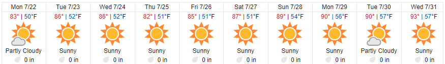
Willamette Valley Weather

“This latest round of weather is extremely concerning,” Oregon State Fire Marshal Mariana Ruiz-Temple said in a statement Sunday. “Our firefighters are doing everything thing they can to rise to this immense challenge, but they are taxed, and we need our fellow Oregonians’ help. Please take precautions to avoid sparking a human-caused fire, be familiar with evacuation levels, and have a go-kit ready in case you need to leave your home.”
Fire Weather Tools from the National Weather Service
As we prepare for the peak of wildfire season in the U.S., the National Weather Service (NWS) reminds wildland fire managers that we have tools to help you monitor and fight wildfires. Whether it is a prescribed burn, ground fire or crown fire, fire managers can use this information to make decisions on how best to combat fires and keep the public safe.
Fire weather forecasters – The NWS issues Fire Weather Outlooks for the next eight days. These outlooks show areas where pre-existing fuel conditions, combined with forecast weather conditions, may result in a significant threat of wildfires.
Our Fire Weather Program supports land managers and firefighters who mitigate and respond to fires. Our weather forecasts are designed to highlight times and locations where a fire may be exceptionally hard to control. For example, we offer Red Flag Warnings, which mean warm temperatures, very low humidities and stronger winds are ongoing or expected to produce an increased risk of fire danger in 12 to 24 hours for specific locations.
Need a fire weather Spot Forecast? Land managers can request a site-specific, localized forecast for prescribed burns and wildfires to assess a potential threat. NWS recently updated this tool and will deliver additional enhancements to the application later this year. Learn more about the new Spot Forecast tool.
For federal and select state large wildfires, onsite weather forecasting support to firefighters is critical. An NWS Incident- Meteorologist (IMET) can be deployed to your incident command post. IMETs arrive on scene within 12 to 24 hours after activation and can serve up to 14 consecutive days before being relieved by another IMET. https://www.weather.gov/news/241507-fire-weather-tools
PLEASE Help Prevent Human-Caused Wildfires
- Immediately call 911 to report fires.
- Drones and other unmanned aircrafts are illegal to fly near fires.
- Fireworks, incendiary/tracer ammunition and exploding targets, are prohibited during fire season (May-October).
- Use caution when target shooting. Clear a 20-foot radius around the target by removing all vegetation and rocks.
- Ensure vehicles and trailers are properly maintained
- Make sure chains and other metal parts are not dragging.
- Keep exhaust systems clean and use spark arrestors.
- Do not park on dry grass.
- Carry extra water, shovel, and/or a fire extinguisher with you.
- Ensure your campfire is completely extinguished before leaving your campsite by making sure it is cool to the touch.
- Please don’t smoke and if you do, don’t throw out cigarette butts.
- Please be mindful and think about your actions
To ensure all Oregonians remain safe during the 2024 wildfire season, we urge everyone to stay tuned into these communications channels and follow all official safety guidelines related to air quality and recreation:
Watch Duty app: Download this app on your smartphone to understand where wildfires are in real time as well as monitor air quality and other metrics. https://app.watchduty.org
Northwest Interagency Coordination Center: During fire season, this web-based interactive map is updated daily with current fire perimeters and locations. This website acts as the wildfire resource coordination center for the Bureau of Land Management, US Forest Service, Oregon Dept of Forestry, US Fish and Wildlife Service, Bureau of Indian Affairs, Washington Dept. of Natural Resources and the National Park Service. https://gacc.nifc.gov/nwcc/index.aspx
InciWeb the Incident Information System: The federal interagency all-risk incident information management system provides an interactive map with real-time location information on wildfires. https://inciweb.nwcg.gov/
Oregon Department of Forestry Wildfire News: The official wildfire news blog for the Oregon Department of Forestry. Look here for all wildfire news related to state forest lands. https://odffire.com/
Keep Oregon Green: A partnership comprised of statewide and interagency groups working together to promote awareness of the risk and causes of wildfires and how to be prepared in case of a wildfire emergency. https://keeporegongreen.org/
OregonLive Wildfire Map: A project managed by OregonLive that incorporates data from InciWeb, National Interagency Fire Center, Northwest Interagency Coordination Center, Oregon Office of Emergency Management, NOAA into an easy-to-use map tool. https://projects.oregonlive.com/wildfires/map
Oregon Department of Environmental Quality – Air Quality Monitoring Data: A real-time map and cell phone application you can use to track air quality, including wildfire smoke impacts, across the state. Check your app store for OregonAir. https://oraqi.deq.state.or.us/home/map
Purple Air – Air Quality Map System: Real-time air quality information using crowdsourced data and data from EPA air sensors. https://map.purpleair.com/1/mAQI/a10/p604800/cC0…
NOAA High Resolution Rapid Refresh Data Visualization: The High-Resolution Rapid Refresh (HRRR) from the National Oceanic and Atmospheric Agency(NOAA) is an experimental data visualization tool for wildfire smoke. Be sure to turn on the “Vertically Integrated Smoke” layer to see smoke paths. https://hwp-viz.gsd.esrl.noaa.gov/smoke/index.html

Fire crews have been tracking and fighting wildfires across the Willamette National Forest this past week, including 22 that were sparked by a lightning storm on July 16 that recorded more than 200 down strikes in Lane County and more than 1,000 lightning strikes across the state.

Because of a rapid initial attack and aggressive fire suppression, 10 of those wildfires have been contained or controlled since July 15. Crews are working hard, and resources are stretched across the region to meet the need as new starts are detected.
Total fires on the landscape this week include 14 fires in the Middle Fork Ranger District, 6 fires in the McKenzie River Ranger District, and 4 fires in the Santiam River Zone and Sweet Home Ranger District. Areas of focus include the Pyramid Fire, the Ore Fire, and the High Prairie Fire, among others. One Complex Incident Management Team (CIMT) took command of the Ore Fire today, and another CIMT was in-briefed for the Pyramid Fire in the Sweet Home Ranger District.
Fire closure orders for public and firefighter safety were issued today for 3 more fires in the Middle Fork Ranger District: The Chalk Fire, the Tire Mountain Fire, and the Moss Mountain Fire near the Diamond Peak Wilderness.
Fires that are contained or controlled include: Skipper, Alpine, Deer Creek, Deer Butte, 199 MR, 202 MR, 226 MR, 212 SRZ, 225 SRZ, and Westfir-Oakridge Rd.
The public is encouraged to stay safe, observe closures, pay attention to evacuation warnings, and avoid active wildfire areas to give firefighters and first responders the room they need to move heavy equipment and work. Visitors are encouraged to support firefighters and crews by recreating elsewhere in the coming days, especially with more lightning activity on the horizon.
Oregon Dept. of Forestry and private firefighting resources including fire engines, water tenders and pump platforms are engaged on the Lane 1 Fire about 13 miles SE of Cottage Grove

As weather permits, two to four aircraft have been engaging on the fire as well.
Lightning started the fire on July 17 on private land protected by ODF’s South Cascade District near the Umpqua National Forest. As of Sunday the fire was estimated at just under 300 acres. The fire is being managed from ODF’s Springfield Office. No structures are threatened and there are no evacuations.
The Bureau of Land Management has closed all public lands, roads, campsites and trails in the area that they manage. The closure is in response to multiple fires currently active in the area. The closure will remain in effect until conditions allow for safe use of the public lands. Details of which lands are affected can be found at https://www.blm.gov/…/bureau-land-management-issues…
Bureau of Land Management issues emergency fire closure in Lane County
The Bureau of Land Management Northwest Oregon District has temporarily closed BLM-managed public lands because of multiple fires in the area southeast of Cottage Grove, within the Sharps Creek and Clark Creek areas. The closure is for public and firefighter safety, and to allow fire suppression crews to continue to safely respond to the incident.
The closure order closes the Sharps Creek Campground and encompasses BLM-managed public lands southeast of the town of Dorena, surrounding Sharps Creek Road (County Road 2460 / BLM Road No. 23-1-12) and Clark Creek Road (BLM Road No. 23-1-13). This includes BLM lands in Township 22S, Range 1W, and Township 23S, Range 1W, Sections 1-3, 11-14, 22-24, 26-27, 33-34. The closure also includes Sharps Creek Road and Clark Creek Road. Members of the public may not enter closed areas, and all uses—including hiking, mining, hunting and dispersed camping—are prohibited. Sharps Creek Road and Clark Creek Road remain open to residents within the closure area. For additional information and the closure map, visit https://www.blm.gov/orwafire.
As it becomes safe to do so, firefighters will begin to assess the closure and their impacts in alignment with sound risk management practices. BLM Northwest Oregon District has additional fire closures and fire restriction information available on BLM.GOV. Please call 911 to report any signs of new fires.
Ore Fire Update


Linn County Sheriff Michelle Duncan is informing the public about the Pyramid Fire burning east of Sweet Home. The fire started today at 3 acres and has grown to 60 acres. A LEVEL 3: GO NOW! Evacuation Alert is being issued for a large area of the Sweet Home Ranger District. This evacuation is being coordinated with the United States Forest Service.
This LEVEL 3: GO NOW! Evacuation Alert means that all roads, hiking trails, campgrounds, lakes, and recreational areas within the evacuation boundary are closed. The public should not enter the LEVEL 3 Evacuation Area. Emergency crews and response vehicles will be heavily present, and public traffic can hinder their efforts to fight the fire.
Sheriff Duncan wants everyone to know that the large evacuation area is necessary to give wildfire response teams enough space to safely travel and fight the fire. The fire itself is much smaller than the evacuation area. No residential structures are in jeopardy of the fire. This LEVEL 3: GO NOW! Evacuation Alert is primarily impacting forest and recreation areas.
Please refer to the Linn County Fire Map https://tinyurl.com/LinnCoFireMap for full details of the issued evacuation area (which will appear in red).To protect Linn County citizens, and all those who recreate in our beautiful county, we strongly urge you to check the following links and sites before heading out.
Linn County Sheriff’s Office Fire Evacuation & Status Live Updates https://www.linnsheriff.org/wildfire_live_updates/ Linn County Sheriff’s Office Wildfire Preparedness & Resources https://www.linnsheriff.org/wildfire-recovery/
Linn County Wildfire Map https://tinyurl.com/LinnCoFireMap
State of Oregon Fires and Hotspots Dashboard https://experience.arcgis.com/…/6329d5e4e13748b9b9f7f3…/
U.S. Forest Service – Willamette National Forest https://www.facebook.com/willamettenfhttps://www.fs.usda.gov/main/willamette/
Oregon Wildfire Response & Recovery https://wildfire.oregon.gov
Oregon Air Quality and Smoke Information Maphttps://www.oregonsmoke.org

** 𝐌𝐭. 𝐏𝐢𝐬𝐠𝐚𝐡 𝐍𝐨𝐫𝐭𝐡 𝐁𝐨𝐭𝐭𝐨𝐦𝐥𝐚𝐧𝐝𝐬 𝐀𝐥𝐞𝐫𝐭 **Lane County Animal Services is using the arena located in the park to shelter livestock and other large animals that have been evacuated from the Oakridge area.

While the shelter is in place, it is important that regular park users give the livestock plenty of space – especially if they have dogs. Please leave a wide buffer between people with dogs and the shelter. We want all of the animals (and the people caring for them!) to be safe. Thank you for understanding as we put the park to a new, emergency use. Information about shelter and the High Prairie Fire can be found at www.LaneCountyOR.gov/HighPrairieFire

LCSO Case #24-3854 – Lane County Sheriff’s Marine Patrol recovers drowning victim on Fern Ridge Reservoir

On Saturday, July 20th at about 3 p.m., Lane County Sheriff’s Office Marine Patrol deputies and Oregon State Police responded to Fern Ridge Reservoir for a report of a drowning. Witnesses reported the victim, a 26-year-old male who was not wearing a life jacket, was swimming from their boat before going under water and not resurfacing.
Volunteers with the Lane County Sheriff’s Dive Team responded. After several hours of searching underwater, the victim was located deceased.
Thanks to the Lane County Sheriff’s volunteers who assisted on this difficult case, as well as the Trauma Intervention Program (TIP) volunteers who responded to assist the witnesses.
Rivers and Lakes in Lane County are still very cold, making them especially dangerous during hot summer days. Please, if recreating in or on the water, wear a life jacket.
Firefighters Tackle Rail Car Fire in Eugene

Eugene Springfield Fire responded to a rail car fire at the Union Pacific rail yard in West Eugene Saturday morning. ESF was dispatched to the fire at 8:35 AM on July 20th.
At 7:00 AM Central Lane Communications received multiple calls of a smoking box car with visible flames at times, as the train made its way to the yard from Oakridge. Tower 2, Water Tender 2, and Battalion 2 from the Whiteaker Station nearby, responded as part of the initial alarm assignment. On arrival, fire crews located the burning boxcar in the rail yard and made access with a hose-line attempting to extinguish the fire.
Firefighters encountered difficulty due to high piled shipping contents in the 53’ long cargo container. Crews cut large holes in the metal box car and were forced to manually remove burning debris to access and extinguish the fire. In all, 3 Engines, 1 Ladder, 1 Tower Company, 2 Water Tenders, a Battalion Chief, Logistical Support Unit, and an EMS Supervisor responded to the Incident. The ESF Fire Marshal’s office is on scene investigating a cause. The main fire was contained to the train car of origin, and there were no injuries reported.

Eugene’s National Night Out is back at the ballgame on July 28!

Join us outside PK Park at 3 p.m. for a free, fun, family-centric community celebration. Meet your favorite K9s and special teams from Eugene, Springfield, UOPD, Eugene/Springfield Fire, and Oregon State Police. Enjoy displays from SWAT, Traffic Team, Bomb Team, K9, Drone Teams, Forensics, Animal Services, and more!Stay for the Monarcas vs. Spokane game at 5 p.m. and celebrate our community partnerships between innings.
Lane County Sheriff’s Office Still Seeking Suspect in Homicide

In June, a deceased female was located in the Cottage Grove area who appeared to be the victim of homicide. Lane County Sheriff’s detectives identified the victim as a missing person, Rozaleena Faith Rasmussen, 29, from Cottage Grove.
Detectives identified the suspect as Anthony Wesley Tyrrell, 31, of Cottage Grove. A nationwide warrant has been issued for his arrest. Tyrrell is described as a white male adult with brown hair, brown eyes, weighing approximately 165 pounds and standing approximately 5’9” tall. He was last seen with his head shaved and wearing a white shirt, black trench coat, black pants, and black boots.
Tyrrell is considered armed and dangerous. Anyone with information about his whereabouts is asked to call 911 and avoid approaching or contacting him.

Applications are being sought until August 14 for this year’s mural project
with four artists selected who will be paid $1,500 each.
The selected artists will paint their murals on September 19 and 20 at four storm drains in the Thurston area of east Springfield.
“When It Hits The Fan”: A New Podcast by Lane County Emergency Management
Lane County Emergency Management is excited to announce the launch of a new podcast, “When It Hits The Fan,” now available on all major podcast platforms including Apple Podcasts and Spotify.

“When It Hits The Fan” is designed to equip listeners with essential knowledge and resources to be prepared and stay safe during a disaster. Whether you’re new to emergency preparedness or a seasoned prepper, the podcast offers can help you face the future with confidence.
“Our goal with ‘When It Hits The Fan’ is to reach community members in a format that’s accessible and engaging,” said Lane County Emergency Manager Tiffany Brown. “We want to provide digestible and actionable information that people can easily incorporate into their daily lives to ensure they are prepared for any emergency. We hope to foster a culture of preparedness and resilience within our community.”
Episodes are share monthly and, so far, include:
- “Welcome! And, what the heck is emergency management?” – An introduction to the world of emergency management.
- “What do you mean we should be two-weeks ready?!” – Practical tips for ensuring your household is prepared for emergencies.
Listen at www.LaneCountyOR.gov/fan.
About Lane County Emergency Management – Lane County Emergency Management is committed to preparing the community for emergencies and disasters through education, planning, and response coordination.


If you are taking a young child to a big event, local Fairs, Six Flags, theme park, Fenway Park or any other busy location … Write your phone number on their wrist and cover it with liquid band aid in case you get separated. Also, take a photo of them using your cell phone the morning of the event so you have their clothing, hair style and up to date photo. Just in case they get lost. Stay safe this summer! #BePrepared#TipofTheDay

Oregon Investigators Offering Reward For Information Identifying Individuals Who Started The 134,000 Acre Cow Valley Fire
Most of the Country doesn’t know that Oregon is absolutely running rampant with wildfires. At least four wildfires are now over 100,000 acres in the state. The Durkee Fire broke 143,000 acres today, The Lone Rock Fire is 117,000 acres, The Falls Fire is 121,000 acres, and the Cow Valley Fire is 133,000 acres.
Fire investigators and law enforcement from multiple agencies put out a public notice asking the public for information leading to identifying individuals who may have started the Cow Valley Fire, The Bonita Road Fire, and others in the Malheur Reservoir area.
Fire managers and investigators say these fires started in a “suspicious manner.” These fires have already cost $10 million and had a massive resource allocation, putting added strain nationally on firefighting resources.
7 Structures were lost on the Cow Valley fire alone.
Reward offered for information relating to wildfires in the Malheur Reservoir area.
VALE, Ore. – Fire investigators and law enforcement officials are requesting the public’s assistance in the investigation of the Cow Valley, Bonita and other small wildfires in the Malheur Reservoir area.
These fires all began in the early morning hours of July 11, between approximately 1 and 5 a.m. They are believed to be human-caused and of a suspicious nature. A monetary reward is being offered for information leading to the identification of individuals responsible.
Anyone with information about any of these incidents should call We Tip Anonymous at 1-800-47-ARSON, online at wetip.com.
This is a multi-agency investigation by the Bureau of Land Management Vale District, Oregon State Fire Marshal, Malheur County Sheriff’s Office, and Oregon State Police.
Shortly after these and other fires broke out, the Pacific Northwest increased its wildfire preparedness to the highest level, a PL5. There are currently 28 uncontained large fires in the PNW, with 11 Teams assigned to these incidents. (SOURCE)
Governor Tina Kotek and the First Lady visited the Larch Creek Fire near Dufur on Sunday

After being briefed by ODF and Oregon State Fire Marshal incident management team members and leadership on the past and current fire operations, she toured the burn scar to see firsthand the success of organized state and local partnerships to protect the community and natural resources.
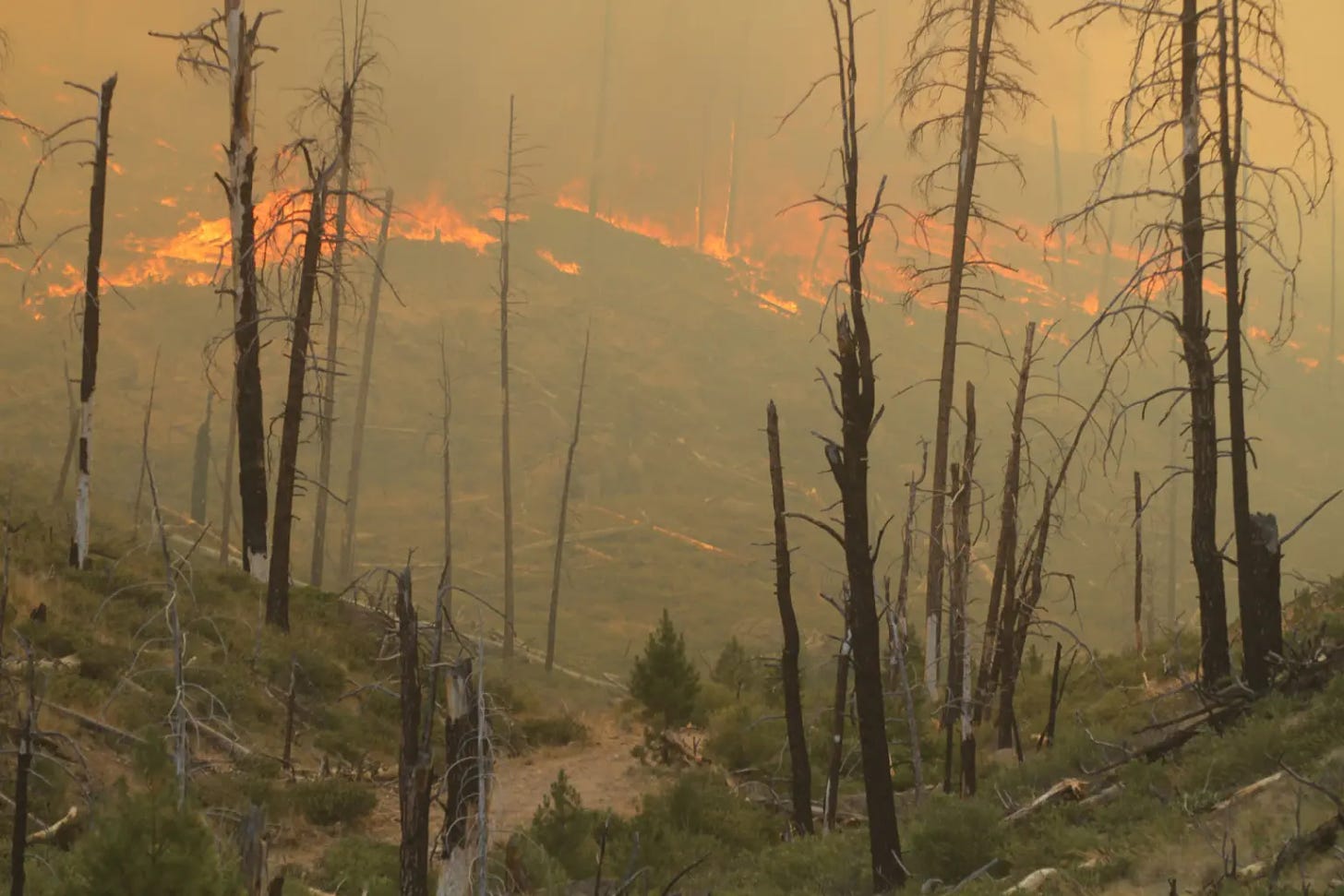
Elevated wildfire risk as Oregon wildfire season off to ‘aggressive start’
A spate of lightning storms coupled with hot dry weather has created high-risk wildfire conditions earlier than expected, officials said
Heat, lightning and wind have conspired to create high-risk conditions for wildfire across southern, central and eastern Oregon far earlier in the summer than state officials anticipated.
“We are fighting fire like it’s August 19, not July 19,” said Mariana Ruiz-Temple, Oregon’s state fire marshal, at a news conference Friday. The wildfire season in the Northwest can last from May through October, but typically the season is most intense from July to September.
As of Friday afternoon, there were 24 large fires of 100 or more acres burning in parts of Oregon, according to the Northwest Interagency Coordination Center, a wildfire prevention and response network that includes nine state and federal agencies across the West.
Northwest Large Fire Interactive Map displays where fires are currently burning in Oregon. (Northwest Interagency Coordination Center)
In just the last week, Gov. Tina Kotek declared five conflagrations – meaning many structures have burned or the scale of the fires exceed local resources. They’re the result of some human-caused fires and thousands of lightning strikes earlier in the week that ignited more than 100 new fires.
Ruiz-Temple and the Oregon Department of Forestry’s deputy director of fire operations, Kyle Williams, said lightning storms that are expected Friday through Monday will further elevate risk. South central Oregon, in the Klamath and Medford areas are at highest risk Friday evening before lightning is expected to move north and east until Monday.
The two doubled down on their pleas to Oregonians to minimize the potential for human-caused wildfires so their agencies can manage scarce resources.
“We have our hands full already, and there’s more lightning coming – we can address that, as long as our resources are not busy dealing with other human caused fires,” Williams said.
So far, the number of human-caused wildfires in Oregon is below average, according to Williams. But because conditions are so hot and dry, those wildfires are getting larger and burning more acres than average.
Burn rules across state and national parks and forests have gone into effect, and fires are allowed only at some designated campsites. Officials recommend ensuring fires are properly doused and put out, that people keep vehicles off of dry grass and ensure vehicle chains are not dragging. The Oregon Department of Forestry recommends avoiding any backyard debris burning during the fire season.
Statewide emergency
On July 12, Kotek declared a statewide wildfire emergency, which enabled National Guard deployment to parts of the state and allowed state and federal resources to flow to areas in need.
“To be very honest, our wildfire season is off to a very aggressive start,” she said.
Oregon has received additional equipment and firefighters from Washington, California, New Mexico, Idaho, Montana, Oklahoma, Texas, Georgia, Colorado and Florida, and Kotek expects more wildfire fighters will arrive in the coming days.
“I cannot emphasize enough: This is a dynamic, fast-moving situation for our state, and we will continue to use every resource, every person that we can get our hands on, to fight these fires,” she said.For more information on how to prepare for possible evacuation, visit: wildfire.oregon.gov
Kotek could not provide details about whether or not the state would exceed its emergency wildfire budget, but indicated costs are adding up.
“I can say, it will be more expensive than the last fire season. I think that’s a safe bet,” she said.
Global issues with CrowdStrike security software taking down Microsoft systems has not impacted the agency’s work or any wildfire response work in Oregon, Kotek said.
Teams from the Oregon State Fire Marshal’s Office, Department of Forestry and the U.S. Forest Service and Bureau of Land Management are working together to protect property and natural resources. Erin McMahon, director of the Department of Emergency Management, said there have been 88 evacuation orders across the state so far this summer.
“Our firefighters are working at all hours of the day and night, in conditions that are hard for many of us to fathom,” Kotek said. “It’s going to be a long wildfire season, and we need each and every one of them.” (SOURCE)

Large Fires in Oregon 7/22/24 7:30am per INCIWEB
| Incident | Type | State | Incident Size | UpdatedSort ascending |
|---|---|---|---|---|
| Falls Fire – ORMAF | Wildfire | Oregon | 132951 Acres | 37 seconds ago |
| Durkee Fire – ORVAD | Wildfire | Oregon | 173758 Acres | 30 minutes 8 seconds ago |
| Lone Rock Fire – ORPRD | Wildfire | Oregon | 116563 Acres | 43 minutes 22 seconds ago |
| Boneyard Fire – OR95S | Wildfire | Oregon | 14602 Acres | 9 hours 32 minutes ago |
| Cow Valley Fire – ORVAD | Wildfire | Oregon | 133490 Acres | 9 hours 34 minutes ago |
| Lane 1 – OR77S | Wildfire | Oregon | 768 Acres | 11 hours ago |
| Red Fire – ORDEF | Wildfire | Oregon | 350 Acres | 11 hours 12 minutes ago |
| Ore Fire – ORWIF | Wildfire | Oregon | 645 Acres | 11 hours 13 minutes ago |
| Diamond Complex – ORUPF | Wildfire | Oregon | 2816 Acres | 11 hours 46 minutes ago |
| Pyramid Fire – ORWIF | Wildfire | Oregon | 500 Acres | 15 hours 57 minutes ago |
| Battle Mountain Complex – OR97S | Wildfire | Oregon | 6408 Acres | 20 hours 42 minutes ago |
| Larch Creek Fire – OR95S | Wildfire | Oregon | 18286 Acres | 2 days 9 hours ago |
| Salt Creek – OR710S | Wildfire | Oregon | 4102 Acres | 4 days 21 hours ago |
| Little Yamsay Fire – ORFWF | Wildfire | Oregon | 6340 Acres | 1 month 3 weeks ago |
| 2023 Chilcoot Fire UNF – ORUPF | Wildfire | Oregon | 1940 Acres | 1 month 4 weeks ago |
| 2023 Chilcoot Fire UNF – ORUPF | Wildfire | Oregon | 1940 Acres | 1 month 4 weeks ago |
| 2023 Ridge Fire UNF – ORUPF | Wildfire | Oregon | 214 Acres | 1 month 4 weeks ago |
| 2023 Ridge Fire UNF – ORUPF | Wildfire | Oregon | 214 Acres | 1 month 4 weeks ago |

Please Help Prevent Wildfires!

In these dry conditions, a single spark can cause a lot of damage. Learn how you can prevent wildfires by visiting the Oregon State Fire Marshal’s wildfire prevention page.

Draft wildfire hazard maps posted for public comment – Oregon Dept. of Forestry
SALEM, Ore. — Draft versions of the statewide wildfire hazard and wildland-urban interface maps are available to the public for review and comment starting today on Oregon State University’s Wildfire Risk Explorer website.

The wildfire hazard map’s purposes are to:
- Educate Oregon residents and property owners about the level of hazard where they live.
- Assist in prioritizing fire adaptation and mitigation resources for the most vulnerable locations.
- Identify where defensible space standards and home hardening codes will apply.
A series of open houses about the state’s new community wildfire risk reduction programs were held from June 3 to July 1 throughout Oregon. It was an opportunity to learn about wildfire hazard assessments, new defensible space and home hardening programs and standards, insurance concerns, and statewide wildfire policy.
“Defensible space around your home and property is just one of the ways Oregonians can be better prepared for wildfire,” Oregon State Fire Marshal Mariana Ruiz-Temple said. “No matter where you live, the simple actions you take to limit where an ember can land and catch fire can make all the difference, saving your home and protecting your community.”
“Home hardening standards are extremely important because they help reduce the risk of ignition to the most vulnerable parts of a home by the embers of a wildfire,” said Andrew Stolfi, director of the Department of Consumer and Business Services. “Once the map is finalized, we will then initiate rulemaking to adopt the home hardening standards, which will be followed by a six-month phase-in period for education and outreach. Importantly, the standards will not apply retroactively. They will be required only in new construction, major additions, and such things as replacing a roof or siding if the home is in both a high wildfire hazard zone and the wildland-urban interface.”
Representatives from OSU, ODF, Oregon State Fire Marshal, Department of Consumer and Business Services Building Codes Division and Division of Financial Regulation, and the Wildfire Programs Advisory Council addressed hours of questions at the events and engaged with over 500 community members.
“The level of engagement at these community meetings was impressive. I attended them all and hundreds of Oregonians had their questions addressed about community wildfire risk reduction programs and how the map supports protecting Oregon’s communities at highest hazard of experiencing wildfire,” said Dave Hunnicutt, Chair of the Wildfire Programs Advisory Council.
At those meetings, early maps depicting wildfire hazard were available, but property tax lot level maps were not yet available. However, draft maps are now ready for Oregonians to see the hazard designation of their specific address, and whether they’re in the wildland-urban interface.
“The maps are still drafts,” said Andy McEvoy, wildfire research scientist at Oregon State University. “The maps won’t become final until we receive input from counties on potential local anomalies, administrative rules are adopted by the Board of Forestry, and we evaluate input from the public.”
The draft maps reflect revisions from the last two years based on input received in 2022 from county governments and the public. Updates include:
- Adjustments for hay and pasturelands.
- Adjustments for northwest Oregon forest fuels.
- Changes based on draft rules to include irrigation of agricultural crops as a mitigating factor in wildfire hazard assessments. Final maps will reflect rules as adopted by the Board of Forestry.
“Work on the wildfire hazard map hasn’t ceased over the last two years,” said Kyle Williams, Deputy Director of Fire Operations at ODF. “ODF and our partners at OSU have worked diligently to evaluate and address concerns about the accuracy of the map. These drafts are still based on the core principles of wildfire science but have been pored through to address expressed concerns. With one more round of public input, we will be well situated to finalize a hazard map that will contribute to advancing wildfire protection in Oregon as the Legislature intended.”
Comments can be sent to dmap@odf.oregon.gov“>hazardmap@odf.oregon.gov. Find more information on ODF’s wildfire hazard web page.
Report Says Oregon is the 3rd Most Dangerous State
In a recent report, Oregon has been identified as the 3rd most dangerous state in the U.S., shedding light on concerning crime trends within its cities. Among these cities, Roseburg, OR, stands out as a focal point for understanding the challenges faced in the state. The report delves into the intricacies of crime rates, highlighting the need for a comprehensive analysis of safety and security measures.

The crime rate in Roseburg, OR is higher than the national average, with an overall crime rate that is 119.5% higher than the national average. Specifically, Roseburg recorded 85 violent crimes, equivalent to 355 per 100,000 residents, which is lower than the national average by 4.1%.
Additionally, the city reported 1,138 property crimes, amounting to 4,747 per 100,000 people, higher than the national average by 142.9%. The City-Data.com crime index for Roseburg is 391, which is 1.5 times greater than the U.S. average, indicating an above-average crime rate in the city.
The crime rate trend in Oregon over the past decade has shown a steady increase in violent crime, as reported by the FBI crime data. Specifically, in the past decade, violent crime in Oregon has steadily risen, according to the recently released FBI crime data.
This trend is reflected in the statistics, with Oregon’s violent crime rate reaching 265.5 per 100,000 people in 2019, indicating a concerning escalation in violent crime over the years. Additionally, the criminal arrest rate in Oregon was reported to be 3,899 per 100,000 residents in 2016, highlighting the prevalence of criminal activities and law enforcement efforts in the state during that period.
The data suggests a notable increase in reported crimes, emphasizing the need for continued monitoring and strategic interventions to address the rising crime rates in Oregon.
The factors contributing to Oregon’s high crime rate include a combination of economic, demographic, and policy-related elements. Research indicates that economic growth, changing demographics, and immigration trends have played significant roles in crime reduction.
Specifically, poverty reductions, reduced urbanization, aging populations, and increases in service sector workers, Latinx and immigrant populations, and reductions in poverty rates have been linked to decreases in violent crimes. Moreover, changes in policing practices and crime prevention policies have also been identified as key drivers in reducing crime rates.
In conclusion, the report highlighting Oregon as the 3rd most dangerous state brings attention to the critical issue of crime rates in the region. With a specific focus on Roseburg, OR, it is evident that concerted efforts are needed to address the underlying factors contributing to crime in the city. (SOURCE)
Recently timeout.com listed the best parks in the United States and Oregon was the only state in the Northwest that made it to the top 10.

Even if you haven’t visited this park on the edge of the Oregon Coast, most likely, you’ve seen it on the big screen. This park, with an amazing outlook toward the Pacific Ocean, has been the backdrop in films including Twilight, The Goonies and Kindergarten Cop.
You’ll see information signs on them and other points of view extending to Haystack Rock, a sea slack in Canyon Beach, and the Tillamook Rock Lighthouse. Wander amid Sitka spruce forests and along a network of hiking trails, including the Clatsop Loop Trail, a two-and-a-half-mile-long historical loop. It partly follows the Corps of Discovery route, which is the Lewis and Clark Expedition military unit that trekked through the present-day park. Or spend time on the sand at Indian Beach. https://www.timeout.com/usa/things-to-do/best-state-parks-in-us
After 30 years, one of Oregon DOC’s Most Wanted Fugitives has been arrested in the state of Georgia
An Oregon Department of Corrections (DOC) adult in custody who fled from a work crew in 1994 is back in custody. Steven Craig Johnson fled from a work crew at the Mill Creek Correctional Facility (MCCF) in Salem on November 29, 1994.

Johnson was arrested in Macon, Georgia by the U.S. Marshals Service, Southeast Regional Fugitive Task Force (USMS SERFTF) on July 16, 2024. He was booked into the Bibb County Jail and is awaiting extradition back to Oregon.
According to the USMS Steven Craig Johnson aka “William Cox,” 70, was taken into custody by the USMS SERFTF on July 16, 2024, at approximately 2:00 p.m. at an apartment complex located at 2087 Vineville Ave. in Macon. Johnson had been a resident there and living under the alias of William Cox since 2011. Johnson was wanted on an Oregon arrest warrant for escape. A copy of the USMS press release is attached. A copy of the DOC wanted poster is also attached.
MCCF was a minimum-security prison located five miles southeast of Salem on 2,089 acres. The facility was unfenced and housed approximately 290 adults in custody who were within four years of release. MCCF opened in 1929 as the Farm Annex of the Oregon State Penitentiary. The prison closed June 30, 2021, by order of Governor Kate Brown.
DOC is responsible for the care and custody of approximately 12,000 individuals who are incarcerated in 12 institutions across the state.
Oregon’s Unemployment Situation Sees Little Change

A release from the Oregon Employment Department said the rate has been in a tight range between 4.0 percent and 4.2 percent since October of 2023. Oregon’s unemployment rate was 4.1 percent in June and 4.2 percent in May.
In June, Oregon’s seasonally adjusted nonfarm payroll employment rose by 600 jobs, following a gain of 4,000 jobs in May. State Employment Economist Gail Krumenauer said June’s gains were largest in three sectors. Krumenauer said they increased by 1,200 jobs in health care and social assistance, 800 in financial activities and 700 in leisure and hospitality. Declines in were largest in professional and business services and manufacturing which shed 1,800 and 600 jobs respectively.
OED said health care and social assistance continued its rapid expansion. During the two-and-half year period between January of 2022 through June of 2024, it added 34,000 jobs or 12.8 percent. Employment gains in social assistance have accelerated in recent months. The industry added 8,800 jobs or 12.2 percent during the past 12 months. Meanwhile, the three health care component industries each added more than 2,000 jobs since June 2023: Nursing and residential care facilities added 2,700 jobs or 5.1 percent, ambulatory health care services gained 2,700 jobs and hospitals added 2,200 jobs or 3.7 percent.
Krumenauer said despite gains in health care and a few other industries recently, the list of declining industries is growing. Six major industries cut a substantial number of jobs in the past 12 months. Three of the major industries each declined by about 3,600 jobs since June 2023: Retail trade lost 3,600 jobs or 1.7 percent, professional and business services shed 3,600 jobs or 1.3 percent and manufacturing lost 3,500 jobs or 2.8 percent. Krumenauer said the other major industries cutting at least 700 jobs in that time were construction which lost 2,700 jobs or 2.3 percent, transportation, warehousing and utilities which shed 1,100 jobs or 1.4 percent and information which lost 700 jobs or 1.9 percent. The U.S. unemployment rate in June was 4.1 percent, which changed little from May.
Average gasoline prices in Oregon have fallen 4.9 cents per gallon in the last week, averaging $3.90/g today, according to GasBuddy’s survey of 1,307 stations in Oregon.
Prices in Oregon are 12.2 cents per gallon lower than a month ago and stand 64.8 cents per gallon lower than a year ago. The national average price of diesel has fallen 4.0 cents in the last week and stands at $3.79 per gallon.
According to GasBuddy price reports, the cheapest station in Oregon was priced at $3.24/g yesterday while the most expensive was $4.79/g, a difference of $1.55/g. The lowest price in the state yesterday was $3.24/g while the highest was $4.79/g, a difference of $1.55/g.
The national average price of gasoline has fallen 1.9 cents per gallon in the last week, averaging $3.47/g today. The national average is up 3.5 cents per gallon from a month ago and stands 9.9 cents per gallon lower than a year ago, according to GasBuddy data compiled from more than 11 million weekly price reports covering over 150,000 gas stations across the country.
Historical gasoline prices in Oregon and the national average going back ten years:
July 22, 2023: $4.55/g (U.S. Average: $3.57/g) July 22, 2022: $5.18/g (U.S. Average: $4.38/g)
July 22, 2021: $3.68/g (U.S. Average: $3.15/g) July 22, 2020: $2.60/g (U.S. Average: $2.19/g)
July 22, 2019: $3.15/g (U.S. Average: $2.75/g) July 22, 2018: $3.27/g (U.S. Average: $2.82/g)
July 22, 2017: $2.62/g (U.S. Average: $2.28/g) July 22, 2016: $2.51/g (U.S. Average: $2.17/g)
July 22, 2015: $3.13/g (U.S. Average: $2.75/g) July 22, 2014: $3.94/g (U.S. Average: $3.56/g)
Neighboring areas and their current gas prices:
- Eugene- $3.71/g, down 4.0 cents per gallon from last week’s $3.75/g.
- Salem- $3.84/g, down 6.7 cents per gallon from last week’s $3.90/g.
- Portland- $4.05/g, down 4.5 cents per gallon from last week’s $4.09/g.
“Most of the country has seen a reprieve from rising gasoline prices, thanks to weaker-than-expected gasoline demand, building supplies and a quiet period in the tropics,” said Patrick De Haan, head of petroleum analysis at GasBuddy. “While a good portion of the nation saw average gas prices decline, severe weather completely knocked out power to a major refinery outside Chicago early last week, immediately impacting gasoline supplies to Illinois, Wisconsin, Indiana and Michigan, and pushing prices up considerably. We’ve often said how critical refineries are, and with a long power outage, we’re seeing the impact very quickly, but relief will eventually arrive. For now, as we approach the end of summer vacations, I’m hopeful gas prices will continue to edge slightly lower in the week ahead.”
Governor Kotek proposes changes to Oregon school funding and half billion dollar boost in next budget
The proposal aims to narrow district funding gaps caused by rising costs and an end of extra federal funding in September
With Oregon’s public schools staring down a fiscal cliff this school year as the historic federal investment from the last few years expires, Gov. Tina Kotek is proposing changes.
She’d like to help schools keep up with rising costs in the years ahead by updating the way schools are funded. She estimates that those changes would bring a $515 million boost to the State School Fund during the 2025-27 school years.
The state’s 197 school districts have spent nearly all of their portions of the $1.6 billion in federal COVID relief money awarded to the state since 2020. The money expires in September and with it, some of the services, programs and staff that it has paid for.
“Across the country, school districts are facing budget shortages caused by the expiration of federal pandemic relief dollars, declining enrollment, increasing costs due to inflation and many other factors,” Kotek said in a news release Wednesday announcing the changes.
They come amid growing calls for funding help from districts. After teachers in the state’s largest district, Portland Public Schools, went on strike for more than a month last fall – in part because of low pay and poor working conditions – Kotek vowed she would review school funding and compensation issues in Oregon.
Leaders in other big districts also issued warnings about their dire budget predicaments following the strike, and in May, several superintendents released a video calling school funding in the state a “crisis” as they explained their decisions to cut hundreds of jobs to keep schools solvent.
They implored the Legislature to increase education spending.
“This is a terrible and devastating, heartbreaking moment for us,” Salem-Keizer Public Schools’ Superintendent Andrea Castañeda said in the video, “and it is not one we’re using to levy blame. It’s one that we’re using to ask for help.”
Officials from various education groups in Oregon expressed relief and gratitude over Kotek’s announcement.
Morgan Allen, deputy executive director of the Coalition of Oregon School Administrators, said it was “hugely positive.” Emielle Nischik, interim executive director of the Oregon School Boards Association, called it a good start.
“The essential work we do for students has to be tied to adequate and reliable funding,” Nischik said in an email. “This doesn’t fix our funding challenge, but it will facilitate a more honest State School Fund debate in the Legislature.”
Years of underfunding
During the long legislative session in 2023, lawmakers passed a $10.2 billion school funding package, the largest public K-12 education budget ever allocated in Oregon. Of that, more than $8.8 billion went to the State School Fund, which pays for the bulk of district budgets.
But school leaders afterwards said that was still not enough following years of underfunding and rising costs due to inflation. Legislators have historically not fully allocated to schools the amount recommended by the state’s Education Quality Commission, which is tasked with ensuring Oregon operates “a system of highly-effective schools” and presents a proposed budget to the governor and the Legislature every two-years.
Oregon school funding has further been stymied by two voter-approved ballot measures passed in the 1990s that have capped the state’s ability to tax property to fund schools. School funding from property taxes dropped by two-thirds in the following years, with the Legislature drawing a greater share of funding from the state’s general fund, which is needed for myriad services in the state.
Sen. Michael Dembrow, D-Portland, chair of the Senate Education Committee and the Statewide Educator Salary Task Force formed by the Legislature in 2023, said improvements to the State School Fund are desperately needed. But he said he’s concerned about where the additional money will come from with no new tax increases or revenue streams proposed alongside them.
“It’s an open question as to what else in the budget might have to be cut in order to bring in this extra half a billion dollars,” he said. “Personally, I worry that it could come from higher education, which is already very much underfunded.”
Proposed changes
The first change Kotek proposes to the State School Fund is to give schools 49% of their allocated budget in the first year of the two-year budget cycle, and then the remaining 51% in the second year, rather than splitting them evenly each year. She said this would help boost funding in subsequent two-year budgets since they are based on the amount allocated for the second year of the previous education budget. This would also help schools cover expenses that might be higher by the second year of a two-year budget. This change would give districts at least $217 million more in their 2025-27 budgets, Kotek’s advisers estimate.
The second proposed change would involve data the state uses to project future compensation. By narrowing the data the state uses for its projections – using the last 10 years of salary data instead of 20 – about $500 million would be added to the money available to schools to hire teachers and classified and administrative staff in the 2025-27 budget.
Lastly, Kotek proposes that the Legislature incorporate annual changes in local property tax revenues. Historically, the Legislature has only taken into account revenue from the first year of a biennial budget when considering what to allocate in the next budget. This limits the state’s ability to send schools more money if property tax revenues rise during a year that’s not counted.
By accounting for local revenue changes every year, state officials could bring in an additional $55 million to the State School Fund for the 2025-27 school year, Kotek’s office estimated.
“The governor said she was committed to this, and she is showing that she is,” Dembrow said of the latest changes. “Looking at how this gets funded in her budget, which will come out in December, will be really interesting to see, because obviously that’s where the proof in the pudding will be.” (SOURCE)
Bags of rice recalled in seven US states as they may contain ‘rodent parts’
Wehah Farms has issued a recall of 4,600 cases of its Lundberg Family Farms Sustainable Wild Blend Gourmet Rice in seven states . This is due to the potential presence of a “foreign object that appears to be of rodent origin.”

The US Food and Drug Administration (FDA) has classified this as a Class II risk recall, indicating that the product may cause temporary or medically reversible adverse health consequences.
The affected products are sold in 1lb bags with the lot code 231004 and a best-before date of October 4, 2024. The recall affects products sold in Arizona, California , Florida , Maine, New Hampshire, Oregon, and Wisconsin, according to Newsweek.
It remains unclear how the product became contaminated with rodent parts. FDA recalls are classified into three levels, with Class II being the second most serious type.
The FDA sets limits on the amount of “extraneous materials” that can be present in food, stating: “maximum levels for these defects in foods produced under current good manufacturing practice and uses these levels in deciding whether to recommend regulatory action.”
According to the FDA: “Extraneous materials include any foreign matter in a product associated with objectionable conditions or practices in production, storage, or distribution.”
They provide examples such as “Examples of filth may include any objectionable matter contributed by animal contamination such as rodent, insect, or bird matter; or any other objectionable matter contributed by unsanitary conditions.”
The FDA stated: “Some foods, even if they are produced in acceptable conditions, may contain natural or unavoidable defects that at low levels are not hazardous to health.”
One of Oregon’s most adorably iconic seabirds is coming to the front and back of a car near you. The Oregon Coast Aquarium has opened voucher sales for its new tufted puffin license plates.

The design, featuring a tufted puffin floating in the ocean and gazing down at some fish below, was created by the
aquarium’s graphic design and marketing coordinator, Cam Mullins.
Starring a tufted puffin—one of Oregon’s iconic seabirds–funds from the new license plate will benefit both the Aquarium’s animals and their wild counterparts. You can purchase a voucher now and exchange it at the DMV once the physical plates are available. We need to sell 3,000 vouchers to reach the production stage—meaning the sooner 3,000 vouchers are sold, the sooner production begins, and the sooner you’ll have your puffin plates in-hand. Read the full story at aquarium.org/puffin-plate-debut![]()
![]() : photo by OCAq’s Jeremy Burke
: photo by OCAq’s Jeremy Burke
Tufted puffins are native to Oregon and nest on the rocky coast. The aquarium has a Seabird Aviary that sustains a flock of these sea birds and the profits from the license plates will go to benefit these puffins and their wild counterparts.
The voucher is available for purchase on the aquarium’s website. The cost covers the $40 surcharge fee and the money left over after the deduction of the DMV’s fees will go to support the Oregon Coast Aquarium’s
rehabilitation and conservation efforts. The aquarium is building a new marine wildlife rehabilitation center with
hopes of doubling the number of animal patients it can offer care to. FOLLOW on FACEBOOK: https://www.facebook.com/OregonCoastAquarium

Oregon’s Missing Persons
Many times you’ll see postings without case numbers or police contact. There is rarely a nefarious reason why (the nefarious ones are pretty obvious). Usually the loved one tried to call to report their missing person and they are either refused or told to wait a day or two by people who are unaware of SB 351 and the laws that they are bound to when answering the phone. Many people don’t bother calling LE if their loved one is homeless or in transition because they believe LE won’t care. The biggest myth is the 24 hour rule.
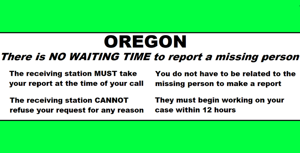
In Oregon we don’t have those rules and an officer or person answering the phone is not allowed to decide. The law decides. We have Senate Bill 351 and it states that the police CANNOT refuse a request for any reason and they must begin working on it within 12 hours. The person making the report does not have to be related to missing person either.
Here is SB 351 written by families of the missing here in Oregon in conjunction with Oregon law enforcement officers. This should be common knowledge, please make it this way. https://olis.oregonlegislature.gov/…/SB351/Introduced

