
The latest news stories and stories of interest in the Willamette Valley from the digital home of Southern Oregon, from Wynne Broadcasting’s WillametteValleyMagazine.com
Friday, July 21, 2023
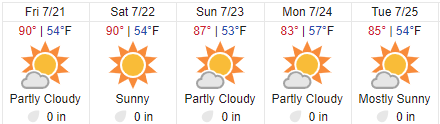
Willamette Valley Weather

Haight Creek Fire Update
According to Oregon Department of Forestry officials, firefighters from multiple agencies have dug a fire line around the perimeter of the 100-acre Haight Creek Fire burning about 13 miles southwest of Veneta.
Forestry officials said that firefighters are preparing to begin containment of the fire, with day crews working to hold and improve the fire line around its perimeter and clearing dead timber and removing flammable materials 20 feet into the fire where possible, state forestry officials said. ODF said removing snags, which refers to dead timber that’s still standing, will be a focus out of safety for firefighters as fire activity slows down.
Safety Notice — Fire Fighting Aircraft at Fern Ridge Reservoir
UPDATE – The previously posted advisory regarding fire-fighting air resources on Fern Ridge Reservoir is being lifted at this time. ——- The Lane County Sheriff’s Office would like to advise the public that fire-fighting aircraft will be scooping water from Fern Ridge Reservoir starting this afternoon in relation to the Haight Creek Fire near Alma. Those recreating on the reservoir are asked to use extreme caution and consider recreating at a different location until further notice.

Juli Moore · sooSrdnpte99h fc8c76m54i996:8Magl6 ya017t21Pt 7i2c 5a51u8Jt2 ·
“We made significant progress overnight, and we intend to build on that progress today,” said Ole Buch, ODF District Forester. “Our intent was to slow the spread and get around this fire to keep it as small as we could to protect natural resources – as safely as possible. We’re very thankful for all our partners on the fire and the tremendous work they’ve achieved. We still have a lot of work ahead of us to ensure that the fire stays within its footprint.”
Forestry officials said that air operations that began on July 19 with six airtanker planes and six helicopters continued on July 20. The fire is burning on ODF-protected Bureau of Land Management-managed land and started on the evening of July 18, ODF officials said.
ODF said the public should avoid the area for their own safety, and Oxbow Road is closed near the fire for the safety of firefighters working in the area.
State forestry officials said that the cause of the fire is currently under investigation. FACEBOOK: https://www.facebook.com/ODFWesternLane
The Lane County Fair in Full Swing


For FAIR Information: https://www.atthefair.com/
LCSO Case #23-3799 — Missing Climber UPDATE
UPDATE 07/20/2023 -Utilizing intel gathered from drone footage, Lane County Sheriff Search and Rescue personnel have located the body of the missing climber on the North Sister. He has been identified as 21-year-old Joel Tranby of Bend. Tranby died after falling several hundred feet down a loose and rocky slope earlier this week. Search and Rescue personnel were able to observe his body from helicopter this morning; however, extremely loose and steep rocky terrain rendered reaching him on foot impossible.
Lane County Sheriff’s Search and Rescue personnel are consulting expert climbers from a number of various sources to determine if a recovery mission can be safely conducted.
We are saddened by this loss of life and extend our deepest sympathies to his family and friends.
———- Lane County Sheriff’s Search and Rescue received the report of an injured climber near the summit of the North Sister on the afternoon of July 17, 2023 at approximately 12:18pm. The caller reported that her boyfriend had fallen approximately 300-500ft down the slope and was severely injured. The caller was unable to see where the victim had fallen or reach him due to the extremely steep and rocky terrain.
A Lane County Sheriff’s Office SAR Coordinator and a Mountain Rescue volunteer arrived in the area via LifeFlight Network helicopter and immediately began searching. The victim is believed to have fallen into a very steep ravine that is made up of extremely unstable large boulders. Unfortunately he stopped responding verbally before searchers arrived. The search team as well as an Oregon National Guard Blackhawk crew were unable to locate him. This area is extremely dangerous and inaccessible to searchers by foot. Additional teams from Lane County SAR, Deschutes County Sheriff’s Office Mountain Rescue, and an AirLink Helicopter also assisted in the search.
The search was resumed yesterday with the Civil Air Patrol utilizing a high-resolution camera, and a ground team comprised of volunteers with Corvallis Mountain Rescue and Eugene Mountain Rescue. They utilized a small Unmanned Aircraft System (drone) to further search the area where the victim is believed to have fallen. No new clues were located; however, searchers will closely analyze the high-resolution photographs utilizing specialized software to attempt to detect possible clues.


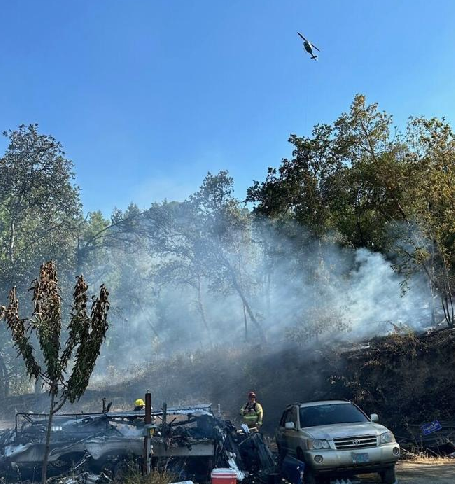
The wildfire that sparked in Southern Oregon’s Siskiyou National Forest on July 15, has spread to over 15,000 acres.
According to the U.S. Forest Service, the Flat Fire, named after the nearby Oak Flat Campground, spread quickly due to high winds in the area and an abundance of fuel, putting nearby communities at risk.
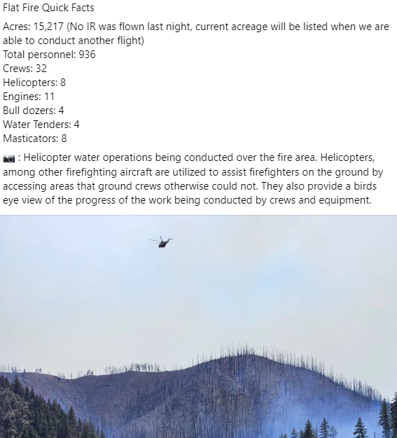
Currently listed at 15,217 acres and zero percent contained, the fire is currently two miles southeast of Agness, Oregon burning through brush and timber and headed towards Wildhorse Ridge to the west.
Current Situation: Firefighters are continuing to secure the north section of the fire, improving protection for the community of Agness. In the northeast, falling modules and feller-bunchers are being utilized to cut down trees. On the west, firefighters have been able to tie control lines from Illinois River to Wildhorse Lookout.
There has been minimal spread to the north with the most active part of the fire being the west flank. In the southeast where the fire is burning in the Klondike Fire burn scar, fire activity is more moderate; this includes two spot fires that occurred earlier in the week.
Tonight’s activities: Night shift crews willbe taking advantage of favorable conditionsto continue small areas of burnout operations in the western flank.
Evacuations: The Curry County Sheriff’s Office issued evacuations notice yesterday from Agness to Quosatana Creek. Curry County is sending evacuation notices utilizing Everbridge, which provides notices via phone. If you have not done so, please sign up by going to the Curry County website and click on the Everbridge notification link. https://www.co.curry.or.us/departments/emergency_management/index.php
Weather: Marine air has moved in and is expected to continue for a few days.
Smoke: SmokeForecast Outlooks are available at oregonsmoke.org
Closures: The Rogue River Siskiyou National Forest has issued a closure order for the fire area including trails, roads, and a portion of the Illinois River. Please be careful when driving in the area due to increased fire traffic. Find the closure order at bit.ly/RRSNFClosures
Restrictions: Fire Restrictions are in placefs.usda.gov/rogue-siskiyou
Crews said the current goal is establishing fire lines to prevent the fire from spreading north towards Agness.
https://inciweb.nwcg.gov/incident-information/xx1002-flat-fire — https://www.facebook.com/flatfireoregon2023
The Boulder Fire southeast of Mt. Hood is now fully contained.
The fire was kept to 233 acres. It was burning in timber, dead and down woody material in rugged terrain. A small team will remain on scene to watch for flare-ups. The cause of the fire is under investigation and the Forest Service is asking anyone who was in the area on July 8th to report if they saw something suspicious or have video or photos that might help with the investigation. https://inciweb.nwcg.gov/incident-information/ormhf-boulder-fire
Douglas County Firefighters Put Out Four Brush Fires In One Day
The Douglas Forest Protective Association said they handled four separate brush fires of various sizes on Wednesday, just before an increase in fire protection levels was set to go into effect.
The DFPA said they first responded to a small brush fire on North Myrtle Street in Myrtle Creek at about 1 p.m. on July 19. That fire was put out and cleared up by 2:18 p.m., but another crew from the DFPA had to respond to another brush fire on southwest Western Avenue at about 2:21 p.m. that same day. DFPA officials said they arrived to help rural fire departments put out the fire, and the scene was cleared by 3:12 p.m.
The DFPA said they responded to yet another fire behind the Flying J truck stop near Oakland at about 3:30 p.m. on the same day. Despite the fire’s proximity to the truck parking area, the fire was quickly contained and the area was cleared by 5:30 p.m.
The DFPA said they also responded to one more brush fire, a quarter-acre fire near the Rod and Gun Club in Canyonville. DFPA firefighters said they went to the scene at about 5 p.m. to find a trailer fire had ignited nearby blackberries, brush and grass. Firefighters said they were able to put out the fire and continue mop-up after a short time, and estimated that it had burned about half an acre in total. The cause of the trailer fire is still under investigation, firefighters said.
The DFPA reminds the public that fire season is in effect, fuels are dry, and fire danger is high. The DFPA strongly advises people using the forests to observe all public use restrictions.
Red Cross Cascades Sees Busy Start to Wildfire Season
Download the FREE Emergency App, build a disaster kit, know evacuations levels
Portland, Ore (July 20, 2023) – The Red Cross Cascades Region is on pace to open more wildfire evacuation shelters this summer compared to last. Shelter openings are four times what they were in June/July 2022. Last summer, 90% of wildfire shelter responses happened in late August/September.
Wildfire Evacuation Shelters Summer 2023
- June 13 – Hat Rock Fire, Umatilla County
- June 14 – Milepost 87 Fire, The Dalles
- July 2 – Tunnel Five Fire, Skamania County, WA
- July 17 – Flat Fire, Curry County
For up-to-date information and alerts about emergencies in your area and shelter locations, download the Red Cross Emergency App from your app store. It’s free and available to both iPhone and Android users.
The Red Cross urges everyone to be prepared should a wildfire occur in your area.
“Disasters can happen anywhere,” says Dawn Johnson, Communications Manager, Red Cross Cascades. “It’s important to take the time now to get your family and home prepared. If you are able, you can also register to become a trained Red Cross volunteer to help those in your community.”
Follow the steps below to keep your family safe.
- Gather your family or household members and delegate responsibilities.
- Assemble an emergency kit to take with you when you evacuate. For a detailed list of items to include visit www.redcross.org/get-help/how-to-prepare-for-emergencies.html
- Prepare an information kit with important documents like medical, banking and insurance records.
- Save a list of emergency numbers on every cellphone.
- Plan ahead for your pets and livestock. Ask local officials where you can bring them.
- Identify a place to meet in case you are separated.
- Plan and practice several evacuation routes from your neighborhood.
If an evacuation is imminent:
- Tune in to local radio and television stations for updated emergency information.
- Limit exposure to smoke and dust. Keep indoor air clean by closing (but not locking) windows and doors. Close curtains, shutters, and blinds. Use the recycle mode on your air conditioner.
- Turn on exterior lights.
- Remove flammable items from decks and porches.
- Open gates for animals that cannot be evacuated.
- Connect a hose to an outside spigot, mark any water sources on your property, and leave a ladder for firefighters.
- Put your emergency kit in your car. Back your car into the garage or park it in an open space facing the direction of escape, with windows closed and keys in the ignition.
- Put your best driver at the wheel. Turn on lights, drive slowly and watch out for emergency vehicles.
Evacuate as soon as the order is given. Don’t delay.
Evacuation Levels – What Do They Mean?
Level 1 – “BE READY!“ for potential evacuation.
Level 2 – “BE SET!” to evacuate. You must prepare to leave at a moment’s notice.
Level 3 – “GO!” evacuate now. Leave immediately!
About the American Red Cross:
The American Red Cross shelters, feeds and provides comfort to victims of disasters; supplies about 40% of the nation’s blood and is the primary blood supplier to 65 hospitals throughout Washington and Oregon; teaches skills that save lives; distributes international humanitarian aid; and supports veterans, military members and their families. The Red Cross is a nonprofit organization that depends on volunteers and the generosity of the American public to deliver its mission. For more information, please visit redcross.org or CruzRojaAmericana.org, or visit us on Twitter at @RedCross.
Bend Murder Victim’s Car Found In Southern Oregon
Bend Police say the SUV belonging to a local murder victim was found in southern Oregon. The vehicle was unoccupied and detectives are en route to collect evidence.
Authorities say 28-year-old Evelyn Jeanette Weaver was found Tuesday morning inside her house on NW Hill Street. BPD’s Sheila Miller states Weaver lived alone. Detectives continue to gather evidence, including collecting surveillance footage from neighbors. “If there are people who we haven’t been in touch with yet, who were with or encountered Ms. Weaver in the days before her body was discovered – so, between July 13th and July 18th – we’re asking people to contact the non-emergency dispatch line,” says Miller, “The Oregon State Police forensics lab is on scene, and we expect to remain on-scene through at least Friday.”

Initial reports were a Bend man called authorities after he went to the home to check on Weaver and found her unresponsive. Police have not yet stated the cause of death or what injuries Weaver may have sustained.
Bend Police said forensics and evidence collection is continuing at Weaver’s home. The Oregon State Police Forensics Lab is also assisting.
Anyone with information that may help police in the investigation, or who interacted with Weaver anytime between July 13-18, is asked to call nonemergency dispatch line at 541-693-6911.
Police would not say if there is a danger to the community and it is unknown if the victim knew who attacked her. Police advise the public to take normal precautions such as locking doors, cars and being aware of surroundings.
Grasshopper Problem in Klamath Basin
For several years, there’s been no water for our farmers in the Basin. Now, the lower Klamath refuge area has a much different but equal problem: Grasshoppers. Some are even calling it a ‘grasshopper plague.’
The Klamath Water Users association has been receiving reports of lost crops. And the organization said grasshoppers are to blame. Main highways, Roads and farmland are covered in these grasshoppers.
The KWUA told us that the dry, hot conditions are ideal for generations of grasshoppers to be born.
As the natural vegetation dries out, the grasshoppers move onto farmlands.
The KWUA said farmers have lost wheat, potatoes, lettuce, and more. The best way to stop it, is what farmers need most this time of year is water……but, that’s unlikely to happen. The KWUA is hoping that the government can allocate water to these infested areas.
Oregon’s Homeowner Assistance Program will start taking applications again on August 2nd.
The program uses federal COVID-19 emergency relief funds. The program was paused in May to process claims. The fund has 72-million-dollars which is enough to help around 500 homeowners. They will focus on homeowners in active foreclosures and those underserved by mortgage markets. The website Oregon-homeowners-assistance-dot-org has more information.
Be Emergency Ready: Financial and Insurance Considerations During Wildfire Season
As most of us in the Pacific Northwest are well aware, wildfire season can have a devastating effect on families, businesses and communities. That’s why there’s so much emphasis on preparation well in advance for a potential emergency—from packing disaster kits to keeping emergency “go” bags close by. This wildfire season, Umpqua Bank is sharing tips for financial preparedness in the event of an emergency, in addition to what you’ve already packed in your disaster kits.
Keep Important Documents Close By
Effective disaster preparedness includes the safe storage of—and easy access to—critical financial and insurance documents you may need in an emergency. Consider keeping these important items in a lockbox you can easily grab and go in a disaster. Or, better yet, check with your bank about their safe deposit box offerings for proper safekeeping. Safe deposit boxes are specifically designed to withstand natural disasters such as floods, fires and tornados.
Documents to consider storing securely in one place include:
- Copy of your passport (or the original if you travel very infrequently)
- Birth certificate
- Marriage license
- Death certificates
- Social Security card
- Copy of your driver’s license
- Titles to your home and vehicles
- Copies of wills, trusts, powers of attorney and medical directives
- Insurance policies
- List of bank accounts, investments and credit cards
- Storage device with photos of belongings and/or an inventory list
- Some cash
If you choose to go the safe deposit box route, “Keep your safe deposit box key on your car ring,” says Heather Seppa, Umpqua Bank Region Manager for Northern Oregon and SW Washington. “A key in a desk drawer can be lost in a natural disaster. Also, consider adding a trusted co-lessor to your box. This person will be able to access the box when and if you can’t.”
Make Sure You’re Insurance Ready
Now is also a good time to check with your insurance agent to ask about the documentation they recommend to have on hand should you need to file a claim. This will likely include things like:
- Detailed photos of expensive items and their serial numbers
- Photos and a list of jewelry, furniture and anything else of greater value or importance
- A video of your home or business and its contents
Remember to back up your photos and videos in the cloud and on a storage device you keep in your safe deposit box.
You may also want to ask your insurer whether your homeowner’s insurance covers your safe deposit items. While bank accounts are covered by FDIC-insurance, the contents in a safe deposit box are not.
Check with Your Trusted Financial Partners
It’s also smart to know ahead of time what types of assistance your financial institution may offer in the event of an emergency. Assistance could include things like the ability to pause payments in the immediate aftermath of a disaster, mortgage assistance if your ability to pay has been impacted or even rebuilding assistance for damaged homes.
If you live in a higher risk area, check with your bank now to see what they offer and what steps you would need to take to access this assistance. Don’t wait until a fire, earthquake or other natural disaster strikes to understand what options may be available to you.
Making sure you’ve considered all of the financial and insurance possibilities can help you move quickly in the event of a disaster, when time is critical for recovery.