
The latest news stories and stories of interest in the Willamette Valley from the digital home of Southern Oregon, from Wynne Broadcasting’s WillametteValleyMagazine.com
Tuesday, September 13, 2022
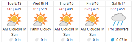
Willamette Valley Weather

Lane County Sheriff’s Office- Armed Barricaded Subject / Death Investigation
On 09/12/22 at 3:52pm, the Lane County Sheriff’s Office received the report of a male assaulting a female at a residence on S. Ash St. near S. 2nd St. just south of Springfield. The 911 caller stated that his step-father was assaulting his mother at the residence.
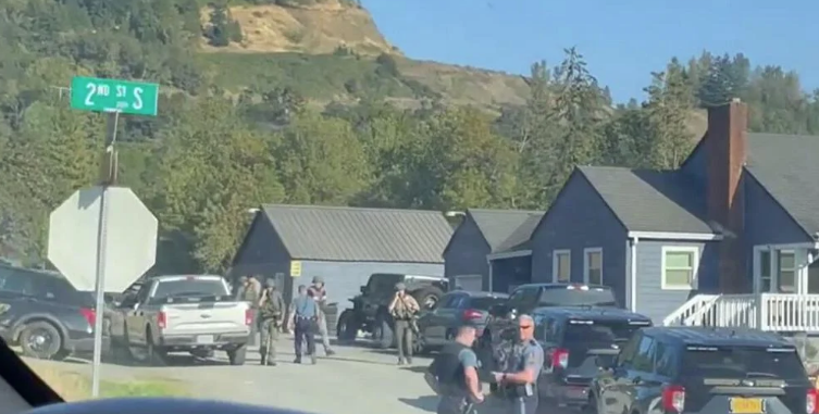
Deputies arrived on scene and entered the residence. They evacuated 7 children, ages ranging from 1 – 11 years old, from within residence. A daycare business is operated at the residence.
Deputies quickly learned that the involved male had barricaded himself with an adult female hostage in the basement.
At 4:19pm, deputies heard the male state that he had a firearm and that he was going to kill her.
The Lane County Sheriff’s Office Special Response Team and Crisis Negotiation Team responded to the scene. The Crisis Negotiation Team consists of trained crisis negotiators from the Lane County Sheriff’s Office, Springfield Police Department, and Junction City Police Department. The Springfield Police Department SWAT team additionally responded, as did negotiators from the Oregon State Police.
Tactical teams positioned themselves to contain the scene and crisis negotiators were able to make contact with the suspect both by telephone and verbally. Negotiations continued for several hours.
At 9:31pm, deputies announced via the radio that shots had been fired and that the involved male was down. Deputies began administering first aid to the male and rushed the female out of the residence and into the hands of awaiting paramedics. Paramedics from Eugene/Springfield Fire had been staged a short distance away since early in the incident. Medics quickly transported the female to a nearby hospital. Preliminary reports are that the female had suffered a non-life threatening gunshot wound to her abdomen.
Deputies attempted to administer life-saving measures to the involved male, however he did not survive and the male was pronounced deceased.
Two Lane County Sheriff’s Deputies advised that they had fired shots from their department issued firearms during the incident. No deputies were physically injured during the incident. The deputies involved in the shooting have been placed on paid administrative leave as is standard protocol in deadly force incidents.
The Lane County Interagency Deadly Force Investigation Team (IDFIT) responded and is investigating the incident. This team is comprised of investigators from numerous outside agencies including the Eugene Police Department, Springfield Police Department, Lane County Sheriff’s Office and Oregon State Police. The IDFIT investigation is overseen by the Lane County District Attorney’s Office. As per IDFIT protocols, any additional information regarding this investigation will be released by the Lane County District Attorney’s Office.
Investigators are expected to be on scene for the next several hours. There is no on-going threat to the public at this time.
Woman Arrested For Arson After Brush Fire on Skinner Butte
A brush fire that sparked on Skinner Butte Monday afternoon has been contained, according to Eugene Springfield fire.
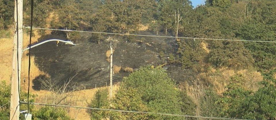

The small brush fire ignited near the top of Skinner Butte on Monday afternoon, destroying grass, trees and bushes above the rock climbing area on the butte’s west side.
The fire was reported at around 5:15 p.m., and the Eugene Springfield Fire Department got it under control within 20 minutes, according to department spokesperson Kelsey Hunter.
According to Eugene Police, the original call that came in was in regards to an armed subject.
Witnesses in the area recall hearing a woman screaming and running down the hill at the time of the fire.
The woman, who is in her thirties, was arrested. Police found a fake pellet gun and a butane torch on her. She is being charged with arson and disorderly conduct. About a dozen firefighters responded to the scene to get it under control.
Drowning near Paradise Campground
One person is deceased after their raft capsized in the McKenzie River, according to the Lane County Sheriff’s Office.
Deputies say at about 8:18 a.m. on September 11, they received information that a raft had overturned on the McKenzie River and one of the rafters was unconscious. Officials say CPR was performed by bystanders and paramedics, but the male victim did not survive.
The LCSO’s initial investigation revealed that the raft capsized and the involved male had gone underwater for some time before being pulled to shore by bystanders. Deputies said all three rafters had life jackets in the boat, but none were wearing them at the time of the emergency.
Cedar Creek Fire Update
Cedar Creek. 15 miles E of Oakridge, OR. Start 8/1. Cause: Lightning. 90,288 acres (+3,554). 0% containment. Timber. Moderate fire behavior. Evacuations in effect. Road, trail and area closures. IMT1, PNW Team 3 transfer of command planned for today to manage the west side of this incident as NW Team 6 transitions off incident.

The fire shut down highway 58 from the 97 junction all the way to Pleasant Hill over the weekend. The city of Oakridge was also without power for much of the weekend. Cedar Creek Fire officials report that the fire is currently burning 86,734 acres and is at 0% containment. OR 58 is now open to all traffic. The Oregon Department of Transportation advises drivers to look out for Cedar Creek fire responders as they are still in the area.
ODOT says there is a work zone between mileposts 56 and 62, east of the Salt Creek Tunnel. They say to expect delays of up to 20-minutes. Traffic is controlled by flaggers and a pilot car. Check TripCheck.com or call 5-1-1 for current road conditions.
Fire officials note that the Lane County Sheriff’s Office lowered some evacuation levels Sunday due to changing conditions and progress on the fire. Evacuation levels in the communities of Westfir and portions of Oakridge were lowered from Level 3 (Go Now) to Level 2 (Set). High Prairie and the areas north, east, and southwest of Oakridge remain in Level 3 evacuation status. Lane County’s latest fire and evacuation information can be found on their website.
People who remain in shelters will continue to receive services provided by the Red Cross. People who have mobility limitations or are particularly sensitive to smoke are encouraged not to return to Level 2 areas.
A Temporary Flight Restriction (TFR) is in place. The use of drones is prohibited in the fire area, please make it safe for our firefighters to use aircraft on the fire. Pacific Crest Trail hikers should visit pcta.org for current information.
The Lane County Sheriff’s Office lowered evacuation levels Monday to lift the entire Oakridge area from Level 3 (Go Now) to Level 2 (Set). Eastern Lane County, east of Waldo Lake and north of Waldo Lake Wilderness, and western Deschutes County remain at Level 3. Fire officials will continue to work with local law enforcement to communicate fire conditions and keep the community safe. People who have mobility limitations or are particularly sensitive to smoke are encouraged not to return to Level 2 areas. Those who choose to remain in shelters will continue to receive services provided by the Red Cross. Smoke continues to create unhealthy air quality, which will likely continue for several more days. Smoke is now impacting communities on the east side of the fire, particularly La Pine, Crescent Lake, Sun River, and Bend.
A virtual community meeting will be hosted by East Zone’s Alaska Team tonight (Tuesday) at 7 pm. Join us on Facebook to learn more and have your questions answered.
West Zone Operations: Pacific Northwest Interagency Incident Management Team 3 led by Incident Commander Randy Johnson assumed command of the West Zone of the Cedar Creek Fire at 6:00 am Tuesday. The team will continue to coordinate firefighting operations with Oregon State Fire Marshal Team Red as well as the Alaska Incident Management Team managing the East Zone of the fire.
The fire remains active and crews were engaged all around the West Zone perimeter with improving fire lines along roads and constructed hand and equipment line. As the sky began to clear on the West Zone Monday afternoon, air operations was able to fly reconnaissance missions to determine where fire growth occurred, verify containment lines, and look for opportunities for increasing containment. The fire was actively burning and was most active on the south side of Salmon Creek.
Tuesday, firefighters will continue to improve and prepare roads to be used as containment line. The fire is backing down toward containment lines. Crews are preparing roads to be used as fireline including Forest Roads 19, 2409, 5871, and 5853. The light precipitation had limited impact to fire behavior and crews are maintaining their momentum in suppression efforts during this window of opportunity. Task forces with the Oregon State Fire Marshal (OSFM) continued to assess and prepare structures Monday. This work included removing fuels and identifying hazards that can make fire suppression work difficult and dangerous. Due to the improved fire conditions, two task forces were demobilized Monday so they can return to their home fire districts. Five task forces from OSFM remain committed to the fire.
East Zone Operations: Operations in the East Zone focus on a containment strategy by strengthening existing or natural barriers. Fire crews remove fuels to create contingency line to protect communities, structures, and other values. The active fire edge with heavy fuels, high concentrations of snags, flammable lichens, and down dead trees is dangerous for firefighters. They engage directly on the fire when conditions are safe to do so. Air operations assist their efforts by dropping water or retardant to slow the fire’s progression. Recent heavy smoke has grounded aircraft, but these operations will resume as conditions allow.
Crews remove fuels along existing roads to improve them as a fire barrier. Along the west side of the Cascade Lakes Highway, crews are using heavy equipment to remove vegetation to create a shaded fuel break. Most of the flammable vegetation is removed, but trees remain, distanced about 40 feet from each other. Crews are brushing forest roads to create a stronger barrier to potential fire spread. In the southeastern edge of the fire, Forest Road 5896 on the north side of Odell Lake and Forest Road 4668 east to Davis Lake are being prepped. On the east edge of the fire area, south of Little Cultus Lake, two miles have been cleared along Forest Road 4290. A taskforce with the Oregon State Fire Marshal Office will be conducting tactical patrols near Crescent Lake and coordinating with local fire resources.
Crews protect structures by clearing surrounding brush, laying hose and sprinklers, and sometimes wrapping structures like signs or historic structures to protect them from fire. Crews have been implementing structure protection actions along Cultus Lake, Lava Lake, Crane Prairie Reservoir, and Odell Lake, among others. These efforts will also continue.
Weather/Fire Behavior: Scattered showers Monday resulted in 2-3 hundredths inches of rain across the fire area. Relative humidity recovery was very good and the heavy smoke layer continued to moderate fire activity. Cooler daytime and nighttime temperatures are expected for the next few days with light westerly winds. Fuels remain dry, especially down, dead trees. Some torching and spotting is expected, but most activity should be creeping and smoldering.
Evacuations: Sign-up for emergency mobile alerts by going to oralert.gov. Please check with Lane County Sheriff’s Office at 541-682-4150 and Deschutes County Sheriff’s Office at 541-693-6911 for updates and changes. Go to https://bit.ly/3D51kvC to view a map.
Closures: The Deschutes National Forest and Willamette National Forest have implemented closures for the Cedar Creek Fire. Please visit Willamette National Forest and Deschutes National Forest for the most recent closure orders and map. A Temporary Flight Restriction (TFR) is in place. The use of drones is prohibited in the fire area, please make it safe for our firefighters to use aircraft on the fire. Pacific Crest Trail hikers should visit pcta.org for current information.
Restrictions: Fire restrictions are in place on the Willamette National Forest and Deschutes National Forest.
Smoke: For current conditions, see Fire.airnow.gov, oakridgeair.org, and LRAPA – Today’s Current Air Quality. Smoke Forecast Outlooks are available at https://outlooks.wildlandfiresmoke.net/outlook.
Online: https://inciweb.nwcg.gov/incident/8307/ | https://www.facebook.com/CedarCreekFire2022/ |
YouTube: https://www.tinyurl.com/cedarcreekfireyoutube
Fire Information: 8:00 AM – 8:00 PM | Phone: 541-201-2335, Media Line: 541-327-9925 |
Email: 2022.cedarcreek@firenet.gov

Weather Cooling Helping Wildfires
A welcome round of early morning showers started the day off west of the Cascades in Oregon and Washington. As the day progressed showers eased over the Cascades at light levels. The cloud cover, humid conditions and lack of winds continued to hamper visibility around ongoing fires. Temperatures stayed in the 60’s and humidity improved, with most areas experiencing good overnight relative humidity recovery. Fire growth on existing large fires was light under favorable conditions. South Central Oregon received multiple lightning strikes, while
The Pacific Northwest will continue to trend cooler as an upper-level trough slowly moves across the region.
Temperatures and humidity will stay near seasonal normal through the week. Around the region there will be some chances for periodic light showers and isolated wet thunderstorms each day. General winds are expected to be light with typical afternoon breezes. The east side of the region should finally see some smoke clearing today.

0800 to 0800
OREGON Strikes = 174
Outflow winds could result in locally gusty conditions. A stronger trough appears to approach next weekend, keeping temperatures moderated and maybe bringing chances for more widespread precipitation, but confidence in this part of the forecast is low.
With cooler, moist weather reducing fire danger, potential for new significant fires will be at or below normal risk through the week. No unusually strong winds are anticipated. Some isolated lightning could cause a few new starts mainly from the Cascade Crest eastward, but not enough lightning is expected to appreciably boost the risk of new significant fires.
Fires continue to burn to the north, south, east and west today. Cooler weather, and even some rain, is welcome news!
Rum Creek. 14 miles NW of Grants Pass, OR. Start 8/17. Cause: Lightning. 21,347 acres (+0). 80% containment. Timber. Minimal fire behavior. Road, trail and area closures.
To the west, a few light showers fell on the Rum Creek Fire and vicinity late Sunday into Monday morning. This moisture was a remnant of Tropical Storm Kay, passing to the south. Skies are clearing again, and the next few days are predicted to be similar to today, cooler and more humid than the end of last week.
It appears the Red Flag warnings are over for now. Fire danger is still heightened, but the completed work makes the
Rum Creek Fire unlikely to grow. Large fuels like logs are dry enough to burn readily, but the finer fuels that usually contribute to rapid fire spread are not as critically dry.
Fire personnel continue to patrol the fire’s perimeter, searching for residual hot spots. Most of the fire’s edges have been cooled at least 200 to 300 feet into the burn. Last night’s infrared flight detected little heat on most of the fire’s perimeter, and showed no acreage gain. Containment is now at 75%.
The hot, dry and windy weather the last few days helped expose remaining hot spots, making some burn more actively and start to smoke. This made them easier to locate and extinguish. Light rain also helps firefighters. Light rain has time to soak into the vegetation and ground, while heavy rain is more likely to run off and cause erosion.
Any moisture, including high humidity and rain, makes the fine fuels harder to ignite and burn. Moisture from rain can soak into the ground, duff layer, and other fuels. If it contacts embers, it cools them and converts to steam. Today firefighters will be watching for wisps of steam, showing the locations of hot spots.
In areas with a layer of ash covering the ground, ash will turn a darker gray as it absorbs rain. The water will evaporate over warmer areas and ash will turn lighter again. Firefighters watch for pale patches of ash and dig for buried heat under them. Some spots will be barely warm, but others will be hot coals. The damp ash and soil can be mixed with the embers to extinguish them, reducing the need for pumps and hoses to relay water.
Van Meter. 13 miles SE of Klamath Falls, OR. Start 9/7. Cause: Unknown. 2,642 acres (+103). 60% containment. Timber. Minimal fire behavior.
The Van Meter fire on Stukel Mountain is just 13 miles southeast of Klamath Falls. The fire was reported on September 7, 2022, at 12:24 p.m. Current size estimate is 3,500 acres with no containment.
An Oregon Department of Forestry Incident Management Team assumed command of the fire at 6 P.M. on September 8, 2022. Additional resources continue to arrive to support suppression operations. Firefighters have made significant progress on the fire, limiting growth with safe, aggressive firefighting.
Structural task forces are working with Klamath County Fire Department 1 and the Merrill Fire Department to provide structure protection within the fire area. Evacuations are in place and the public is asked to stay out of the area for safety of the firefighters and to allow for suppression activities. The Bureau of Land Management has issued a closure order for lands around the fire.
Double Creek. 10 miles SE of Imnaha, OR. Start 8/30. Cause: Lightning. 155,297 acres (+909). 15% containment. Timber. Active fire behavior. Evacuations in effect. Road, trail and area closures. These teams are also managing Nebo, Sturgill, Goat Mountain One and Goat Mountain Two incidents.
Firefighters and air resources continued their efforts to contain a fire that spotted across the west bank of the Imnaha River. Air resources dropped 56 loads of retardant on that fire since it was discovered Saturday afternoon.
Oregon State Fire Marshal (OSFM) task forces worked in Big Sheep Creek to protect structures in the area. Crews are working to connect handlines to stop the fire growth on the west side of the Imnaha River. North of the Double Creek Fire, operations will begin implementing a fire line on the ridges to help keep the fire from impacting additional private lands.

We want to keep you informed about COVID-19 in Oregon. Data are provisional and change frequently. For more information, including COVID-19 data by county, visit our dashboard: http://ow.ly/HtkW50KHj6g


Senator Wyden Announces Oregon the First State To Earn Federal Approval for Medicaid Reimbursement of Mobile Crisis Intervention Services
Senator Ron Wyden announced today that Oregon is the first state to earn federal approval for Medicaid reimbursement of community-based mobile crisis intervention services that help those struggling with mental health and substance use disorders.
“This great news for Oregon clearly demonstrates how our state continues to lead the nation when it comes to reimagining a more humane and effective response for people in a mental health crisis,” said Wyden, Chair of
the Senate Finance Committee. “In the true spirit of the ‘Oregon Way’ focusing on smart solutions, CAHOOTS has long proven a success at de-escalating these crises by getting people the mental health help they need without involving law enforcement.
The approval by the Centers for Medicare and Medicaid Services (CMS) of Oregon’s Medicaid state plan amendment to provide qualifying mobile crisis intervention services is the first since the American Rescue Plan became law
last year.
I worked to get federal resources in the American Rescue Plan so state Medicaid agencies like Oregon’s could secure planning grants that put them in position for major milestones like today’s that advance on the groundbreaking path pioneered in Eugene,” Wyden said.
And this approach reworking law enforcement by sending trained mental health responders to a mental health crisis instead of police marks another key step in Wyden’s work to extend the successful mobile crisis intervention model
pioneered in Eugene with the CAHOOTS program operated by the White Bird Clinic; throughout Oregon and the country. https://www.wyden.senate.gov/news/press-releases/wyden-oregon-the-first-state-to-earn-federal-approval-for-medicaid-reimbursement-of-mobile-crisis-intervention-services
The Oregon State Hospital has been cited for three workplace safety violations by Oregon OSHA.
Details of the violations have not been released. But the Oregon Health Authority, which oversees the hospital, said in a press release that it has to do with the way the hospital has responded to workplace violence and injuries. Staff members at the state-run psychiatric facility have been repeatedly assaulted by patients.

OHA director Patrick Allen said in a statement that any violence towards employees is unacceptable and that the agency is working hard to reduce rates of workplace violence.
“We must do better, and we will do better,” said Allen. “We appreciate what the Oregon-OSHA violations bring to light, we will continue to partner with our hospital staff to find additional ways to prevent workplace violence.”
Allen said the hospital has hired a violence prevention consultant and is using a new assessment tool to help identify patients who may be more prone to violence. Allen said in recent years, staff and patients have had to cope with staffing shortages and COVID-related restrictions.
Coast Guard Rescues Fishermen off Coos Bay Coast
The Coast Guard rescued two fishermen from a disabled vessel offshore Oregon Sunday.

Watchstanders at the 13th Coast Guard District command center in Seattle received a report at 9:21 p.m. Friday that the 66-foot fishing vessel, Lodestar, lost all means of propulsion and was stranded in a storm battling 8-to-12-foot waves and over 40-knot winds approximately 180 miles offshore Coos Bay.
Coast Guard watchstanders diverted the crew of U.S. Coast Guard Cutter Stratton (WMSL 752) to rescue the people.
The cutter crew arrived on scene at 1 p.m. Saturday and placed the fishing vessel in tow. The crew towed the vessel toward shore and transferred the towed vessel and survivors to a 47-foot Motor Lifeboat crew from Coast Guard Station Coos Bay approximately 45 miles offshore Coos Bay.
The boatcrew transported the vessel and survivors to shore Sunday and moored the vessel in Charleston.
“I’m extremely proud of this crew,” said Capt. Stephen Adler, the commanding officer of Stratton. “They showcased remarkable proficiency and seamanship rescuing these two fishermen, who were subject to the perils of the sea, far from land. Yesterday, the crew certainly lived up to her ship’s motto of ‘We Can’t Afford Not To.’”
Elliott State Forest and South Slough Reserve Reopen to Public
South Slough Reserve and the Elliott State Forest have reopened to the public, following a closure due to extreme wildfire danger.

On Friday, September 9, South Slough Reserve and the Elliott were closed after the National Weather Service issued a Red Flag Warning for southwest Oregon indicating critical fire conditions. The Red Flag Warning has since been lifted, following the movement of cooler, moist weather into the region.
Oregon is still in the middle of wildfire season. Visitors are asked to help prevent wildfires by following burn restrictions and fire-safe practices when recreating at South Slough Reserve or the Elliott.
The Department of State Lands will continue to monitor conditions. For the latest updates, visit www.oregon.gov/DSL.
Two Oregon State Parks host volunteer events on National Public Lands Day
Jessie M. Honeyman Memorial State Park and the Historic Columbia River Highway Trail are seeking volunteers for work projects on Saturday, Sept. 24 in honor of National Park Lands Day.
The work is part of the 100 Volunteer Projects for 100 Years series, which commemorates the Oregon State Parks centennial. Projects have included volunteer opportunities at Tom McCall Preserve, Wallowa Lake State Park, Nehalem Bay State Park and others.
On Sept. 24 volunteers can pick from two projects
- Jessie M. Honeyman: work alongside park staff to plant native trees and shrubs to help increase shade cover and replace plants that have been trampled or crowded out by others in the campgrounds. Participants must register by Sept. 19 at https://store.oregonstateparks.org/index.cfm?do=v.dsp_item&itemId=162&eventId=235. Volunteers of all ages are welcome, but those younger than 18 must come with an adult.
- Historic Columbia River Highway Trail: This trail is frequented by visitors from all over the world, and is a favorite of bikers and hikers looking to enjoy stunning views of the Columbia River Gorge. Work alongside park staff to cleanup this section of the trail. Participants must register by Sept. 19 at https://store.oregonstateparks.org/index.cfm?do=v.dsp_item&itemId=162&eventId=234. Volunteers must be at least 10 years old. The work includes using hand tools and moving on gravel and uneven surfaces.
Tools and equipment will be provided at both locations. Bring water, gloves and clothes suitable for the weather.
Visit the event calendar for additional events in 2022. Join the events and participate in the legacy of service that has sustained the state parks system for the past century. Oregon Parks and Recreation Dept.


This is just a small compilation of missing women and their pictures in the area. There are of course women missing all over Oregon and men and children missing too. We don’t mean to dismiss that, however, there is an inordinate amount of women who go missing each week and there could possibly be a connection with an anomaly or two here and there. Sadly most of them never get any attention. Family and friends must keep any information going and lead investigations so that they aren’t just forgotten.


https://www.facebook.com/pg/Have-You-Seen-Me-Southern-Oregons-Missing-People-161249961222839/posts/
