
The latest news stories and stories of interest in the Willamette Valley from the digital home of Southern Oregon, from Wynne Broadcasting’s WillametteValleyMagazine.com
Friday, August 5, 2022
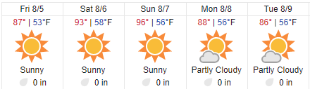
Willamette Valley Weather

Fire Near Dexter Destroys Shop and RV
A fire at a shop near Dexter has completely demolished a building and an RV, and left one person with minor injuries.
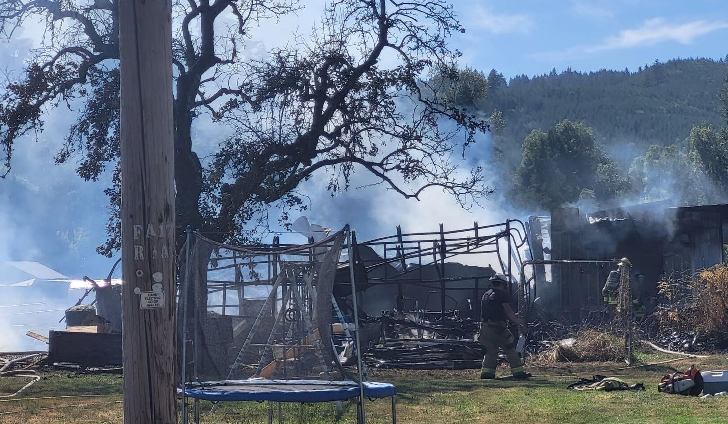
Fire officials say they responded to a reported structure fire on Rattlesnake Road just before 3 p.m. on Thursday, August 4. Crews reportedly arrived to find a shop and an RV engulfed in flames. Crews leapt to extinguish the fire, and after a short battle during which a propane tank reportedly exploded, the fire was 100% contained. Crews worked on clean up operations.
Officials said that although the shop and RV are total losses, the fire did not spread far due to the surrounding green grass. Officials say a local resident suffered minor burns, but there were no injuries to firefighters. Crews from the Dexter Rural Fire Protection District, Lowell Rural Fire Protection District, and Eugene Springfield Fire responded.
Suspect Arrested in Stabbing Death Near Creswell

Thursday morning at approximately 1:05am, the Lane County Sheriff’s Office received a call that someone had been stabbed at a residence in the 84000blk of Cloverdale Rd. The caller advised that her ex-husband had stabbed her boyfriend before departing the location on foot.
Deputies quickly arrived on scene and attempted life-saving measures including CPR. Medics arrived and also attempted to revive him, but the victim did not survive. The victim’s identity is being withheld pending next of kin notification.
An extensive area search was conducted however the suspect was not immediately located. He was identified as 42-year-old Brandon Travis Lamb.
Later in the morning detectives from the Lane County Sheriff’s Office, Oregon State Police, and Springfield Police Department tracked Lamb to an apartment complex near 1st St. and F St. in Springfield. He was found in a vehicle in the parking lot and taken into custody without incident.
Lamb will be lodged at the Lane County Jail on charges including Assault in the Second Degree. This case is still under active investigation.
Fire Restrictions Start Today in Willamette National Forest

Fire restrictions will go into effect on the Willamette National Forest beginning Friday. Except in designated campgrounds, all campfires, charcoal or briquette fires, pellet fires, or any other fires will be prohibited. Restrictions will also go into effect for chainsaws, generators, and smoking.
The recent heat wave has accelerated the drying of fuels across the forest. The dry conditions are receptive to new ignitions and are conducive to rapid fire spread. The fire restrictions apply to all lands within the forest except the Three Sisters, Mt. Jefferson, Mt. Washington, Waldo Lake, and Diamond Peak Wilderness areas.
Portable cooking stoves, lanterns and heaters using liquefied or bottled fuel are still allowed if they can be switched on and off. Visitors should ensure there isn’t any vegetation around or immediately above these devices when in use. Smoking is not allowed except within an enclosed vehicle or building, a developed recreation site, or in areas devoid of vegetation.
Additionally, welding, or operating an acetylene or other torch with open flame is also not allowed. Generators are permitted only in areas devoid of vegetation such as a paved area or developed campsite. Motorized vehicles may operate only on designated trails and roads, including within the Huckleberry Flats and Santiam Pass OHV areas.
“The restrictions are in place to reduce the chances of human-caused wildland fires,” said Fire Management Officer Ed Hiatt. “Criteria for determining when an area should be placed under fire restriction is determined locally with the input of partnering agencies and communities. Criteria include fire danger, preparedness levels and local risk factors.”
Hundreds of Job Opportunities Await Job Seekers at The Oregon State Fair Job Fair — Job Fair is happening Saturday, August 6th at the Oregon State Fair and Exposition Center
[SALEM, OR] The Oregon State Fair – is hiring hundreds of people for seasonal jobs at the 2022 Oregon State Fair – happening August 26 through September 5. The Job Fair begins at 9am Saturday, August 6 in the Pavilion on Sunnyview Road and goes until all positions are filled. Interviews will take place in person and Fair Managers, Carnival, Fair Lift, and Concessionaires will be on hand to hire qualified applicants on the spot.

This all-inclusive employment event will showcase jobs in Admissions, Parking, Admin, Carnival, Security, and Concessions. Job seekers should bring their picture ID, along with a social security card or birth certificate / or a passport. Applicants must be 16 or older for Carnival and Concession positions and 18 or older for Carnival Ride positions.
Job Fair Breakdown:
When: August 6, 2022 – 9:00 am until all positions filled
Where: Oregon State Fair & Exposition Center Pavilion – 2330 17th Street NE Salem, OR 97301
Bring: Picture ID, social security card or birth certificate / or a passport
Parking: Plenty of free parking – (enter from Sunnyview Road)
More information: info@oregonstatefair.org
Fair links
Volunteer opportunities: oregonstatefair.org/volunteer/
Tickets: (Fair/Carnival/Concerts/Fast Pass/Parking) oregonstatefair.org/tickets
Newsletter: (latest news and contests) oregonstatefair.org/newsletter
Media Kit: (with image downloads) oregonstatefair.org/business-center/media-kit/
About the Oregon State Fair:
The Oregon State Fair is a public/private entity owned by the people of Oregon. The Fair began in 1861 in Oregon City. In 1862, the Fair moved to the Oregon State Fairgrounds in Salem, the State Capitol. The Oregon State Fair and Exposition Center hosts thousands of visitors from all over the world each year, with premier concerts, art, culture, rides, agricultural exhibits, and livestock exhibits. Throughout the year, the Fair and Expo Center works with multiple agencies to help facilitate emergency and disaster response needs. For more information, visit oregonstatefair.org or contact us at info@oregonstatefair.org —- Oregon State Fair

We want to keep you informed about COVID-19 in Oregon. Data are provisional and change frequently. For more information, including COVID-19 data by county, visit our dashboard: http://ow.ly/GwK150Kc1yu

OHA releases COVID-19 vaccine breakthrough report
PORTLAND, Ore. – Oregon Health Authority’s most recent update on COVID-19 breakthrough cases, released today, reported 40,013 cases of infection during the month of July.
Of those cases, 18,622, or 46.5%, were unvaccinated people, and 21,380, or 53.4%, were vaccine breakthrough cases. Among the breakthrough cases, 14,388, or 67.3%, were fully vaccinated and boosted.
To date, there have been 292,802 COVID-19 vaccine breakthrough cases in Oregon. Of those cases, 103,563, or 35.4%, were fully vaccinated and boosted at the time of infection.
To date, 2.6% of all vaccine breakthrough cases have been hospitalized, and 0.6% have died. The median age of vaccinated people who died is 80.
COVID-19 vaccines are safe and effective at protecting people from getting seriously ill, being hospitalized and dying. The Centers for Disease Control and Prevention recommends COVID-19 primary series vaccinations for everyone age 6 months and older and COVID-19 boosters for everyone age 5 years and older, if eligible.
Note: The next breakthrough report will be published Thursday, Sept. 8. — The latest breakthrough report can be found here.

State Forester Announces Next Steps for Statewide Wildfire Risk Map
Cal Mukumoto, Oregon State Forester and Director of the Oregon Department of Forestry, issued the following statement Thursday:
Oregon’s wildfire environment has changed significantly in the past decade. Climate change is bringing us hotter, drier summers and historic levels of drought, resulting in severe wildfire conditions and longer, more complex and more expensive fire seasons. We find ourselves at a critical juncture when it comes to wildfire and need to take bold action to mitigate further catastrophic impacts to Oregonians, communities and our state’s natural resources.
Senate Bill 762 laid the foundation for that bold action. The bill passed in 2021 with bipartisan support and made investments in fire-adapted communities, wildfire response and resilient landscapes. Eleven state agencies are tasked with implementing the various components of SB 762. The Oregon Department of Forestry was directed to develop and maintain a statewide wildfire risk map. The map identifies the risk of a wildfire occurring in a given area to help determine where resources are needed most to protect lives and homes when a wildfire does occur.
In addition to writing the rules for map development and maintenance with a rules advisory committee, we were also tasked with defining the wildland-urban interface and assigning a risk classification at the property ownership level (1.8 million tax lots across Oregon). This work had to be completed by June 30, 2022, less than a year after the bill was adopted. We knew the first iteration of an undertaking of this scale and complexity wouldn’t be perfect, but we have been and continue to be committed to improving the map and our processes related to it. At the same time, our partner agencies are working to collect input as they develop the new codes for defensible space (Office of the State Fire Marshal) and home hardening (Building Codes Division) and address concerns related to homeowner’s insurance (Division of Financial Regulation).
We’ve been soliciting and collecting questions, concerns, and other input since the statewide wildfire risk map was released just over a month ago. We’ve received specific feedback from nearly 2,000 Oregonians that has helped us understand the key areas of concern related to risk classification. We have a window of opportunity before the new codes go into effect to take some immediate steps toward addressing those concerns, and we will be taking full advantage of the opportunity.
As required by SB 762, we posted a wildfire risk map on the Oregon Explorer on June 30, 2022 and sent notifications to property owners in the extreme and high risk classifications shortly after. In response to input received since posting, we have decided to remove the current iteration of the wildfire risk map from the Oregon Explorer and withdraw the notices sent. We will immediately begin working with Oregon State University on some refinements to improve the accuracy of risk classification assignments based on what we’ve heard from property owners thus far.
Since we are withdrawing the initial map and notifications, the current appeals process will end and any appeals filed will become moot. For those who did submit an appeal, we will be reviewing the information submitted and using it to identify any additional areas where we may need to take a closer look at the data. Please note, this decision does not impact the code development and adoption processes currently underway through Office of the State Fire Marshal for defensible space or Building Codes Division for home hardening.
While we met the bill’s initial deadline for delivering on the map, there wasn’t enough time to allow for the type of local outreach and engagement that people wanted, needed and deserved. Once this round of refinements is complete, we are planning to bring a draft of the updated map to communities for discussion and input. After another round of revisions based on local input, the map will be finalized. We will then post an updated map on the Oregon Explorer and issue new notices to property owners in the extreme and high risk classifications, which will start a new appeal period. We are in the process of developing a plan and timeline to complete these activities, including public engagement and outreach opportunities. We will share that publicly as soon as it is complete.
We know how important it is to get this right, and we’re fully committed to continuing to work with the Governor’s Office, legislators, our partner agencies, local governments, and Oregonians to do just that.
The following is information from multiple official agencies about fires in Oregon. These include Central Oregon Fire Information, Willamette National Forest, and Wasco County Sheriff’s Office.
Windigo Fire and Potter Fire
Fire growth on the Windigo and Potter Fires was minimal yesterday. Air and ground resources continued to work on initial attack addressing 14 lightning strikes and multiple spot fires outside of the fire perimeters. The start near Little Dome Rock is now being referred to as the Shelter Fire. It is currently three acres and 80% lined around the perimeter. The La Grande Hot Shot crew was able to fully contain an additional small fire. The Windigo Fire is currently pushing east around the butte. Water hose was put along the southeast corner as well as one load of fire retardant. Eastside resources such as the Zig Zag and Baker River Hot Shots will work on primary and alternate lines to keep the fire west of the Pacific Crest Trail. Staff on the northwest side will continue to lay hose and monitor the perimeter.
Yesterday, crews on the Potter Fire continued to clear roads and create connecting lines around the perimeter. Today, resources will be focusing on improving line and scouting for ways to go more direct. Initial attack will continue in both areas with the support of two Type 1 helicopters and one Type 3 helicopter. Fire behavior will continue to be moderate with a high temperature of 80 expected for the Windigo Fire and a high of 75 expected for the Potter Fire. West winds will be between 5-9 mph with gusts of up to 20 mph on ridge tops. Fire spotting distances may be up to ¼ – ½ mile. For information about air quality visit https://fire.airnow.gov/. Windigo Fire
- Acreage: Approx. 1,093 acres
- Containment: 0%
- Location: 20 miles southwest of La Pine, OR
- Cause: Under Investigation
Potter Fire
- Acreage: Approx. 125 acres
- Containment: 0%
- Location: 8 miles northeast of Toketee area
- Cause: Lightning
Area closures and restrictions include:
- Pacific Crest Trail from OR Highway 138 (PCT mile 1848) to OR Highway 58 (PCT mile 1908)
- Forest Service Road (FSR) 60 from the junction with FSR 6020 on the Deschutes National Forest to FSR 2612 on the Umpqua National Forest
- Forest Service Road (FSR) 2610 from Lemolo Dam to Calapooya Mountain
- Kelsey Horse Camp on the Umpqua National Forest
- White Fish Horse Camp on the Deschutes
- Toketee Air Strip
- Temporary Flight Restriction over the two fires
Cedar Creek Fire
The Cedar Creek Fire, caused by lightning over the area in the last few days, is about 1,200 acres and approximately one mile west of the Black Creek Trailhead on the 2421 road, about 17 miles due east of Oakridge, Oregon, west of Waldo Lake, and north of Highway 58. The fire continues to be very active, moving north, spotting in all directions and putting up a large plume visible from Oakridge. The PNW 2 Type 1 Team, with Incident Commander Mike Minton, will be taking the fire and will in-brief Thursday evening. There is an emergency closure order for the Cedar Creek Fire. Forest users are asked to avoid Forest Roads 2421 and 2424. Also closed are all trails and trailheads on the west side of Waldo Lake including Black Canyon, Cupit Mary, Waldo Mountain, Gander Lake, Winchester Lake and the west side of Waldo Lake Trail from South Waldo Shelter to Rigden Butte Trail.
Green Butte Fire
Firefighters responded to Incident #537, the Green Butte Fire, on the evening of Tuesday, August 2. The fire is located on the Bend-Fort Rock Ranger District on the Deschutes National Forest approximately 13 miles southeast of La Pine and approximately two miles northeast of Spring Butte. The fire is currently mapped at 22.9 acres and 0% contained.
Yesterday firefighters stopped forward progress and completed the installation of a hose line around the fire. Due to increased complexity, a local Type 3 Incident Management Team led by Incident Commander Andrew Myhra will take command of the fire today.
Resources assigned to the Green Butte Fire include the Prineville Hotshots, two hand crews, four engines, three water tenders, and one dozer. Air resources are available if needed.
Fly Creek Fire
There were no changes on the 274-acre Fly Creek Fire overnight, it remains 80% contained. This fire is located near Balancing Rock along the Metolius arm of Lake Billy Chinook on the Deschutes National Forest. Resources will be on scene again today mopping up and working to increase containment. Air support will be available if needed. Portions of Lake Billy Chinook may be closed for public safety if air resources need to dip out of the lake. The Level 1 evacuation notice for the Three Rivers area and the Level 3 evacuation notice for the Perry South and Monty Campgrounds remain in place. For information on evacuations, please visit: https://www.facebook.com/JeffersonCountyORSheriff.
Green Butte Fire
Firefighters responded to Incident #537, the Green Butte Fire, on the evening of Tuesday, August 2. The fire is located on the Bend-Fort Rock Ranger District on the Deschutes National Forest approximately 13 miles southeast of La Pine and approximately two miles northeast of Spring Butte. The fire is currently mapped at 22.9 acres and 0% contained.
Yesterday firefighters stopped forward progress and completed the installation of a hose line around the fire. Due to increased complexity, a local Type 3 Incident Management Team led by Incident Commander Andrew Myhra will take command of the fire today.
Resources assigned to the Green Butte Fire include the Prineville Hotshots, two hand crews, four engines, three water tenders, and one dozer. Air resources are available if needed.
Miller Road Fire
Wasco County, OR – OSFM Task Forces and ODF crews completed their first 24-hour work cycle. Crews worked to create fire containment lines and were supported by air operations. Dozer lines and hand lines were established in the southeast corner of the fire near Ditch Road and Natural Pasture Road. Additional lines were also completed to the north near Old Wapinitia Road. Firefighters called in aircraft for retardant and water drops to assist with fire suppression and containment. Late into the afternoon, the fire spotted over the line east of Batty Road and west of Old Wapinitia Road in a field of wheat. Crews and land- owners were able to extinguish it and back burn to create some black. With great sadness, we are reporting one primary residence was lost to the fire. Fire crews were working to protect the structure at the time. High winds and ember showers were present.
Four Task Forces and one dozer were assigned evening shift. There were no new starts, and the fire did lay down. Today, firefighters will begin the mop-up process on the heal of the fire, along west Miller Road. They will be checking for hot spots and increasing the control line. Cooler conditions are expected today with temperatures reaching 82-85 degrees. Westerly winds are predicted to be 5-10 mph. Minimal relative humidity recovery overnight. The weekend forecast predicts temperatures increasing to 100 degrees We are grateful for the cooperation and support of the Wasco County community, ODF partners, BLM cooperators and the firefighters dedicated to this incident.An evacuation shelter has been established at the Dufur High School, 802 NE 5th Street. Wasco County Sheriff’s Office evacuation details can be found by visiting https://www.facebook.com/WascoCountySheriff.
Juniper Creek Fire
The firefighters have maintained 50% containment on the 1.6-acre Juniper Creek Fire. This fire is located roughly 10 air-miles south of the Fly Creek Fire and resources will be on scene again today extinguishing hot spots and strengthening control lines. Incident 535 which is located roughly 20 miles southeast of Bend and north of Hwy 20 was contained yesterday at 0.5 acres.
McKinney Fire Updates
Firefighters have gotten their first hold on California’s deadliest and most destructive fire of the year and expected that the blaze would remain stalled through the weekend.
The McKinney fire near the Oregon border was 10% contained as of Thursday morning and bulldozers and hand crews were making progress carving firebreaks around much of the rest of the blaze, fire officials said at a community meeting.
The southeastern corner of the blaze above the Siskyou County seat of Yreka, which has about 7,800 residents, was contained. Evacuation orders for sections of the town and Hawkinsville were downgraded to warnings, allowing people to return home but with a warning that the situation remained dangerous.
About 1,300 residents remained under evacuation orders, officials said.
The fire didn’t advance much on Wednesday, following several days of brief but heavy rain from thunderstorms that provided cloudy, damper weather. “This is a sleeping giant right now,” said Darryl Laws, a unified incident commander on the blaze.
In addition, firefighters expected Thursday to fully surround a 1,000-acre spot fire on the northern edge of the McKinney Fire.
The fire broke out last Friday and has charred nearly 92 square miles of forestland, left tinder-dry by drought. More than 100 homes and other buildings have burned and four bodies have been found, including two in a burned car in a driveway.
The blaze was driven at first by fierce winds ahead of a thunderstorm cell. More storms earlier this week proved a mixed blessing. A drenching rain Tuesday dumped up to 3 inches on some eastern sections of the blaze but most of the fire area got next to nothing, said Dennis Burns, a fire behavior analyst.
The latest storm also brought concerns about possible river flooding and mudslides. A private contractor in a pickup truck who was aiding the firefighting effort was hurt when a bridge gave out and washed away the vehicle, Kreider said. The contractor had non-life-threatening injuries, she said.
However, no weather events were forecast for the next three or four days that could give the fire “legs,” Burns said.
The good news came too late for many people in the scenic hamlet of Klamath River, which was home to about 200 people before the fire reduced many of the homes to ashes, along with the post office, community center and other buildings.
McKinney Fire and Yeti Complex (Alex and Yeti Fires) Perimeter Updates as of 8/5/22 7 AM (Siskiyou County, CA)
An infrared flight was conducted late last night over the fires. Based on the current known perimeter data, the McKinney Fire is estimated to be 59,636 acres and 10% contained. The Yeti Fire is at 6,436 acres. The Alex Fire which is the northernmost fire near Condrey Mountain is 151 acres with no perimeter growth in the last 48 hours. The Yeti and Alex fire remain at 0% containment.
The new Smokey Fire north of the McKinney Fire was mapped at 34 acres. It is 100% lined as of this morning. Moderate fire behavior with backing and flanking has been observed. It is burning on private timberlands, wildlife habitat as well as cultural and natural resources threatened. Type 1 CA Team 2 (Johnny) in command.
For a full link to fire information please see the InciWeb links below:
McKinney Fire: https://inciweb.nwcg.gov/incident/8287/
Yeti Complex and Alex Fire: https://inciweb.nwcg.gov/incident/8299/
For evacuation information click the link below:
https://community.zonehaven.com/?latlon=41.82241712634084,-122.95539351264563&z=10.422241185395976&fbclid=IwAR2NcFJOcoJmIzHjkxPtLrrSw7OnxuzmPojFrcLUgelVl85ZxR7haS29xKA
Oregon Imposes Rules Forcing Hospitals To Disclose When They Declare Staffing Crisis And Begin Rationing Care For Patients
Unnerved by ongoing severe staffing shortages at Oregon hospitals, the state has re-imposed temporary rules forcing hospitals to be public and transparent when they declare a staffing crisis and begin rationing care for patients.
The rules took effect July 29 and are to remain in place through Jan. 24 of next year. They are a continuation of temporary rules the state initially imposed this past January.
“The new temporary rule is based not on the omicron surge and instead reflects the staffing shortages that are impacting hospital capacity now,” Jonathan Modie, an Oregon Health Authority spokesperson, told The Lund Report. He said the rules are intended to ensure that patient care continues to reflect transparency and equity, “even in resource constrained periods.”
The rules require a hospital to post on its website and at “conspicuous locations” around the facility that it is experiencing a staffing emergency and implementing triage standards to prioritize who gets care.
They also require a hospital to disclose, on request, the triage procedures — the “crisis standards of care tool” — that it is using, and tell patients and their support people about triage decisions.
It must also promptly notify the Oregon Health Authority when it begins using crisis standards of care, and compile demographic information about each patient affected by a triage decision, including gender identity, race, ethnicity and disability.
The previous temporary rules, imposed Jan. 17, lapsed on July 15.
Immediately after the rules lapsed, executives at the St. Charles Health System in Central Oregon announced internally — but not to the public or state regulators — that they were facing an acute staff shortage. St. Charles wasn’t using the declaration in order to begin rationing care, however, as Oregon Public Broadcasting reported. Rather, the system’s leaders used the declaration to try to override the system’s state-mandated internal nurse staffing plans, protocols jointly developed by staff and management that spell out nursing assignments, procedures and staffing levels. But St. Charles quickly canceled the crisis declaration after the state objected, OPB reported.
Two weeks later, the state re-imposed the temporary rules.
The rules leave it up to hospitals rather than the government to declare when there is a staffing crisis.
But that crisis declaration decision should be made by the government, not individual hospitals, argued the Oregon Association of Hospitals and Health Systems, the industry group representing hospitals.
“If crisis standards of care do become necessary after coordinated measures to prevent that outcome have failed, we think there should be a formal declaration by the government,” wrote CEO Becky Hultberg to the state on July 28 in comments on the temporary rules.
Oregon’s entire health care system — not just hospitals — are struggling with staffing shortages, Hultberg wrote. “The system is breaking down across the continuum, from ambulances to hospitals to post-acute and more.”
The issue of how hospitals prioritize patient care has simmered for years, but emerged as a flash point during the COVID-19 epidemic, when waves of patients threatened to swamp the availability of intensive care unit beds, ventilators and other equipment.
In 2020, the health authority issued informal crisis-of-care guidelines, which it elaborated on in early January 2022 with more detailed voluntary guidelines. A group of state lawmakers quickly responded, urging the agency to impose rules that have the force of law to ensure that short-staffed hospitals don’t discriminate against patients who are elderly, developmentally disabled, suffering from chronic illness or are members of minority communities.
The state health authority should impose “a clear set of standards coupled with transparency, open communication and simple data collection will benefit all parties and will inform the longer-term discussion about health equity,” wrote the lawmakers, Sen. Sara Gelser Blouin, D-Corvallis; Sen. Elizabeth Steiner Hayward, D-Portland; Rep. Maxine Dexter, D-Portland; Rep. Rachel Prusak, D-Tualatin; and Rep. Lisa Reynolds, D-Portland.
The temporary state rules imposed in January and re-issued on July 29 largely do that.
While the rules were initially imposed due to an omicron surge, Modie said, “Since that time the numbers of COVID hospitalizations have decreased, but hospitals are still facing capacity challenges due to a combination of issues.”
According to the health authority, those issues include:
- Hospitals are still treating more than 400 COVID patients across the state.
- Hospitals are seeing more non-COVID patients who delayed routine care throughout the pandemic and now those patients’ medical needs have grown more urgent and more acute.
- Hospitals are having difficulty discharging patients because long-term care facilities and community-based outpatient providers have their own staffing challenges.
- Hospital staff are worn out from the past 28 months of pandemic and some staff have left as a result of this.
- Federal funds to pay for temporary staff are no longer available.
- As COVID infections rise, hospital staff are also getting exposed or infected and that impacts their ability to work.
Oregon’s hospitals each have their own internally developed protocols for how they prioritize patients for, for example, ICU care, in the event there aren’t enough beds or staff for all who need one. Hospitals are supposed to obey state and federal laws barring discrimination based on race, disabilities, age and other factors. But hospitals keep their triage protocols to themselves.
The temporary rules require hospitals to make those public, including to the affected patient, if they implement them.
The rules follow several years of wrangling between the state and advocates for people with disabilities, who fear that doctors at some Oregon hospitals have allocated ICU beds, ventilators and other equipment improperly taking into account a patient’s disabilities, pre-existing medical conditions or chronic illness that may shorten their long-term lifespan.
Disability Rights Oregon told the Oregon Health Authority in 2020 that the state must ensure that people with disabilities, or who are elderly or from communities of color, are guaranteed the same rights as others to crisis health treatment. A hospital shouldn’t deny someone critical care on the assumption that after discharge, the person might, due to other illnesses, have a low quality of life or just a short time left to live, the advocacy group argued.
MORE INFO: https://www.oregon.gov/oha/PH/RULESREGULATIONS/Documents/PH_166-2022.pdf✎ EditSign
Berry And Fruit Tree Growers Work To Protect Crops From Heat Wave
Berry and fruit tree growers across the Northwest have been taking extra precautions to keep their crops cool through the heat wave that hit in late July and is continuing.

Industry experts say that although triple-digit temperatures can negatively impact fruit quality, there doesn’t appear to be any serious crop damage this summer — a relief after last June’s “heat dome” destroyed many berries and tree fruit crops.
“The heat dome event last year was unusual in that the heat came so intensely and so early in the season,” said Jon DeVaney, president of the Washington State Tree Fruit Association.
In 2021, Pacific Northwest air temperatures reached 117 degrees Fahrenheit in some locations. Based on infrared thermometer readings, Lee Kalcsits, associate professor of tree fruit physiology at Washington State University, measured some fruit surface temperatures exceeding 140 degrees Fahrenheit when no sunburn protective sprays were used.
Although the Northwest has seen hot weather the past few weeks, DeVaney said these temperatures in the low 100s Fahrenheit are within the range of what growers are used to handling.
The 2021 heat wave sunburned cherries, apples, blueberries and other fruits across the region, forcing some growers to abandon crops or leave significant portions unpicked. The event cost Washington state about one-fifth of its cherry crop.
This year, in contrast, workers had already picked most of the region’s cherries before the heat wave arrived. According to DeVaney, as of Sunday, Washington’s cherry industry had shipped about 10 million boxes of cherries out of a forecasted 12.5 million boxes for the total crop.
“We’re close to being through harvest,” he said.
Apple and pear orchards seem to be faring OK in the heat wave, said DeVaney, although growers are taking extra precautions.
Some apple growers are using sprinklers or micro-sprinklers to keep fruit cool.
Many have also installed shade cloth, but that is an expensive option. Industry estimates range from $2,000 to $4,000 per acre for materials plus installation labor. Many growers focus on protecting high-value, more heat-sensitive varieties such as Honeycrisp.
Berry growers are similarly thinking about how to protect berries from future heat waves.
“This is not nearly as bad as what we saw last year. But any time we have these heat events, the berry crops really struggle,” said Scott Lukas, assistant professor of horticulture at Oregon State University. In September, he will step into his new role as leader of the berry research program at OSU’s North Willamette Research and Extension Center.
Lukas said the berry industry does not have “great mitigation techniques” for protecting fruit from high temperatures. Some growers use irrigation systems equipped to do overhead cooling. Others install shade cloth.
Both options, however, are costly.
Researchers, Lukas said, are also exploring developing new berry varieties that can withstand high temperatures. But that takes time, so Lukas said he hopes researchers will also develop more immediate solutions, including protective sprays.
Gas Prices Slowly Decreasing But Could Climb Again as Demand for Gas Rising
Gas prices are decreasing by double-digits in 39 states, including Oregon, in the past week, says AAA.
According to a AAA report, the national average for regular unleaded gas this week is $4.19, and the average for Oregon slides a dime to $5.05, which is close to the national record high that was reached on June 14 at about $5.02 for unleaded premium.
Oregon reached its record high on the following day, June 15, at about $5.49 for regular unleaded gas, and since then the prices have steadily declined.
However, AAA experts say the decline may come to a halt due to the demand for gas rising.
Nationwide and statewide gas prices have dropped for seven consecutive weeks and experts say this is due to the price fall of crude oil and the low demand for gas.
More Than Half A Dozen People Have Died On Oregon Waterways In Just The Past Two Weeks

More than half a dozen people have died on Oregon waterways in just the past two weeks. The most recent drowning was a teenager at Fern Ridge Reservoir near Veneta and at Cottage Grove Lake, in Lane County… A 75-year-old man went into the water while boating Tuesday and didn’t resurface.
Ashley Massey, with the State Marine Board, says environmental factors can have a big impact on a person in the water, “Exposure to sun, to heat, to glare on the water, to wind, to noise. And then you add on top of that physical exertion, like swimming and getting back out, chasing your friends, jumping off a dock or any of that other activity.”
She says victims don’t realize they’re in trouble until it’s too late, “Often times, when you’re just lounging around and floating on a lazy river, you may not recognize those impacts on your body, until you have to exert yourself.”
Massey says there are proactive steps you can take, “Staying hydrated with water. Avoid caffeinated drinks and alcohol, of course; any type of impairing substance. Also, wear a hat and sunscreen, and that glare really does impact you so wear sunglasses, too. And then, take frequent breaks in the shade.” And, she urges everyone to wear a lifejacket, regardless of swimming ability.
Since July 22nd, incidents in the Portland-metro area and Lane, Deschutes and Jefferson counties claimed the lives of at least seven people. While one victim was 17, most are adults. Massey says around 85% of victims in fatal boating incidents were not wearing a life jacket, “It’s state law that if you’re in a boat that’s underway and you’re under 13, you have to wear a lifejacket. And we’re not seeing those kids get injured or involved in fatal accidents. We need to incorporate, not just what we tell our kids but take that behavior on ourselves.”
Click HERE for a map of life jacket loaner stations around the state.
According to the Oregon State Marine Board, there have been 11 recreational boating fatalities so far this year; six occurring in July. Seven involved nonmotorized watercraft like kayaks, canoe, raft, SUP or sailboat. Four were motorized, involving open motorboats and a personal watercraft.


Women Missing Since May 1st 2022 between Medford, Grants Pass and Roseburg per Oregon State Police
| MAKENNA KENDALL 5/3/2022 |
| ERICA LEE HUTCHINSON 5/26/2022 |
| MARIAH DANIELLE SHARP 6/12/2022 |
| KAITLYN RAE NELSON 6/14/2022 |
| BROOKLYN JOHNS 6/14/2022 |
| DONNA LEPP 6/27/2022 |
| BARBARA DELEPINE 7/4/2022 |
| ****KENDRA MARIE HANKS 7/7/2022 FOUND MURDERED 7/21/2022 |
| CORI BOSHANE MCCANN 7/8/2022 |
| SHYHAILA SMITH 7/12/2022 |
| ALEZAE LILYANNE MARTINEZ 7/13/2022 |
| RAVEN RILEY 7/13/2022 |
| TAHUANA RILEY 7/13/2022 |
| DANIELLE NEWVILLE 7/14/2022 |
| CONNIE LORAINE BOND 7/19/2022 |
| KARIN DAWN RUSSELL 7/19/2022 |
| CHEYENNE SPRINGS 7/19/2022 |
| KAREN ANNETTE SCIORTINO 7/22/2022 |
| MARLENE HICKEY 7/23/2022 |
| MAKAYLA MAY VAUGHT 7/23/2022 |
| WENDY JEAN HAZEN 7/26/2022 |
| SHAHE SOPHIA CATRANIDES 7/27/2022 |
Women Missing Since May 1st 2022 in Lane County per Oregon State Police
| REISA RAQUEAL SIKEL 5/3/2022 |
| HANNAH MARIE RHOTEN 5/17/2022 |
| MARISSA ALEESA DAMBROSIO 5/18/2022 |
| ISABELLA BROSOWSKEYOUNGBLOOD 6/7/2022 |
| LOUISA DAY AVA 5/28/2022 |
| AMY CHRISTINA SULLIVAN 6/1/2022 |
| NIKKI ELIZABETH ZEREBNY 6/6/2022 |
| SHADOW STAR SEVIGNY 6/17/2022 |
| SHAUNA LEAH HOGAN 6/17/2022 |
| AIRIONNA CHEALSEY RHODES 6/27/2022 |
| KARISSA RENEE ADAMS 7/6/2000 |
| VERONICA ESSYNCE DELERIO 7/6/2022 |
| AUBRIE HANNA STEPHENS 7/10/2022 |
| LARA IVEY STEINMETZ 7/11/2022 |
| SARA LINDSAY SCHAEFER 7/12/2022 |
| ANGELINA MARIE NAZAR 7/16/2022 |
| LUCIA MARTHA PANNIER 7/17/2022 |
| MALINA LINN COATS 7/20/2022 |
| KATHY A VERNACCHIO 7/23/2022 |
| LILLY ANNE WARMUTH 7/28/2022 |
| MALINA LINN COATS 7/29/2022 |
| JORDYN CLARA GOHL 7/31/2022 |
| QAVAH ALAH TILLILIE 7/31/2022 |
As of 8/2/2022, there are now 44 women missing between Medford and Eugene. Sadly Kendra Hanks has been found murdered, though that takes her off the list. We send thoughts and prayers to her family as well as the families of all missing people in our area.
44 women missing in 3 months. That averages out to 14+ missing per month. Something needs to be done.
This is just a small compilation of missing women’s pictures in the area. There are of course women missing all over Oregon and men and children missing too. We don’t mean to dismiss that, however, there is an inordinate amount of women who go missing each week and there could possibly be a connection with an anomaly or two here and there. Sadly most of them never get any attention. Family and friends must keep any information going and lead investigations so that they aren’t just forgotten. https://www.oregon.gov/osp/missing/pages/missingpersons.aspx


https://www.facebook.com/pg/Have-You-Seen-Me-Southern-Oregons-Missing-People-161249961222839/posts/
