
The latest news stories and stories of interest in the Willamette Valley from the digital home of Southern Oregon, from Wynne Broadcasting’s WillametteValleyMagazine.com
Thursday, July 22, 2021
Willamette Valley Weather
Today– Sunny, with a high near 83. North wind 8 to 10 mph.
Friday– Sunny, with a high near 88. Calm wind becoming north 5 to 9 mph in the morning.
Saturday– Sunny, with a high near 92. North northwest wind 5 to 10 mph.
Sunday– Sunny, with a high near 91.
Monday– Sunny, with a high near 88.
LOCAL HEADLINES:
Eugene Approves Two New Safe Camp/Sleep Sites
The Eugene City Council approved two new sites for the unhoused, located at Chase Commons Park and 310 Garfield St.

The four-acre site at Chase Commons Park will accommodate up to 20 conestoga huts. Officials said they’ve done outreach with nearby businesses and residents.
Meanwhile, the 310 Garfield Street location will accommodate between 50 and 60 people. The property is owned by Lane Transit District and is about five acres in size. Outreach at this location included discussions with nearby property owners, renters and real estate agents.
City staff members have reviewed more than 300 locations for shelter and tent sites and vehicle camping. They said they will continue to assess other properties as well, including both public and private sites.
Eugene/Springfield Create New Evacuation Zones
Officials in Eugene and Springfield are launching a new way to help residents near both cities evacuate in the event of an emergency.
Eugene-Springfield Fire helped split up Eugene and Springfield into dozens of different zones that will help narrow down which residents need to evacuate and where they need to go.
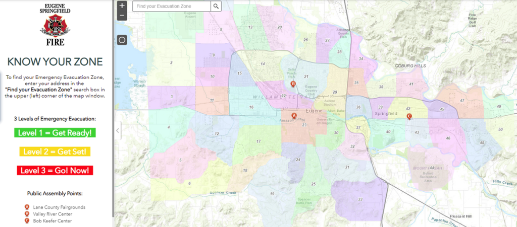
The emergency zones could be used in case of an emergency like severe weather, wildfires and flooding.
The evacuation zones will allow community members, emergency services, emergency managers, and 9-1-1 to use the same language when trying to coordinate an evacuation. The numbered zones cover both cities, fire districts and extend past urban growth boundaries.
Lane County will continue to send emergency alerts for evacuations to your cell phone and over radio and TV, and this will make that process smoother.
If you want to learn what zone you’re in, the city has posted an interactive map on their website.
AROUND the STATE of OREGON
Campfires Banned In State Parks, State-Managed Forestland East Of Interstate 5 Effective Thursday, July 22
Due to fire danger and limited firefighting resources across the western U.S., effective Thursday, July 22 no campfires will be allowed in state parks and in state-managed forests east of Interstate 5, even in designated campfire areas. This includes charcoal fires, cooking fires, warming fires, charcoal briquettes, pellet grills, candles, tiki torches, and other devices that emit flames or embers. Portable cooking stoves or propane lanterns using liquefied or bottle fuels are allowed, though propane fire pits are not.

This ban covers all state-managed parks and forestlands east of Interstate 5, and includes prohibitions on fires in designated fire rings. The public can also anticipate restrictions in other areas based on fire danger. Restrictions may increase as fire danger rises in other parts of Oregon and will remain in place until conditions moderate.
State agencies strongly encourage checking fire danger levels and associated restrictions in a given area before traveling and daily during a visit.
With hot, dry weather expected to continue and no relief forecasted in the foreseeable future, and several large fires on Oregon’s landscape, the step of banning campfires east of Interstate 5 was deemed a necessary measure to protect life and property in what is already a very challenging and dangerous fire season.
Particularly in times of elevated fire danger, maintaining capacity to respond quickly to new fire starts is critical. Humans cause on average 70% or more of fires in Oregon, and these additional restrictions are intended to help reduce the number of human-caused fire starts. This will allow firefighters to focus on the existing large fires as well as new blazes that may emerge.
“We are seeing record-low humidity in much of the state, and as forest fuels dry out there is tremendous potential for fire to establish and spread quickly”, Oregon State Forester Nancy Hirsch said. “With months of fire season left, this measure will help us prevent one of the most common types of human-caused fires, which reduces the risk to our communities and natural resources.”
“Every park visitor can do their part to protect the landscapes we all love”, Lisa Sumption, Oregon Parks and Recreation Department Director said. “Help reduce fire risk by bringing meals that don’t require heating or cooking.” Oregon Dept. of Forestry
Gov. Brown Holds Press Conference On The State’s Wildfire Response
Governor Kate Brown is urging residents to be prepared for wildfires and the possibility they might have to evacuate. Brown issued the warning yesterday. She says this is one of the worst fire seasons in the state’s history. Brown says everyone should have two week’s worth of supplies and be registered at the website OR ALERT DOT GOV to
receive emergency alerts.
WILDFIRE UPDATES
Wildfires in the American West, including one burning in Oregon that’s currently the largest in the U.S., are creating hazy skies as far away as New York as the massive infernos spew smoke and ash into the air in columns up to six miles high.
Skies over New York City were hazy Tuesday as strong winds blew smoke east from California, Oregon, Montana and other states.
The Bootleg Fire grew to 606 square miles — half the size of Rhode Island. Fires also grew on both sides of California’s Sierra Nevada. In Alpine County, the so-called California Alps, the Tamarack Fire caused evacuations of
several communities and grew to 61 square miles with no containment. The Dixie Fire, near the site of 2018’s deadly Paradise Fire, was more than 90 square miles and threatened tiny communities in the Feather River Valley region.
Bootleg Fire:
Weather conditions were favorable again yesterday as crews work to secure lines on the nation’s largest wildfire, the Bootleg Fire in Klamath and Lake counties. On the northern edge of the fire, line was constructed to Long Creek and firefighters scouted a line to tie into the anchor point near the Sycan Marsh Nature Conservancy.
The reduced fire activity yesterday allowed firefighters to construct dozer line directly against the fire edge along the north and east boundary of the Log Fire. There is expected northeast movement of the fire toward Winter Ridge and Summer Lake later in the week.
Firefighters are continuing to work around the southeastern corner of the fire, where the majority of recent growth has occurred. As the fire pushes up into the old Watson Fire burn area, fuels become less continuous and fire behavior is decreased. Firefighters continue to patrol the fireline along the southern to northwestern flanks of the fire.
Monument Spared in Bootleg Fire
A monument to one of the most curious tragedies of World War II was spared from the flames of the Bootleg Fire by fire crews, according to the Klamath County Museum.
The Mitchell Monument, located northeast of Bly within the Fremont National Forest, commemorates the only American deaths by enemy action in the continental US during the entirety of World War II — the result of a largely unsuccessful campaign by the Japanese government to float thousands of bomb-laden balloons across the Pacific
Ocean in order to rain terror down on their enemies.
Situated in the Fremont National Forest just south of Gearhart Mountain, the Mitchell Monument was directly in the path of the Bootleg Fire during its inexorable spread to the southeast. But extra effort from fire crews seem to have spared it from the worst the fire had to offer. According to the Museum, firefighters wrapped the stone monument with flame-retardant and insulating blankets. It’s unknown if the shrapnel tree a few feet from the monument survived.
Jack Fire:
The fire is currently at 19,352 acres with 55% containment. North of Hwy 138, firefighters will continue to hold control lines and mop up as needed.
South of Hwy 138, crews along the west flank will be patrolling lines while mopping up where feasible. Along the south and east flanks, firefighters will be continue to protect control lines and secure Horseshoe Bend campground. Within the Calf Creek area, firefighters will be focusing on managing fire control lines to reduce the chance of fire spread. Crews will also be scouting the southern flank for any potential areas to build alternate fire lines to tie into existing line in Calf Creek.
Elbow Creek Fire:
The Elbow Creek Fire, 17 miles northwest of Wallowa, is estimated at 18,599 acres and is 20 percent contained. The fire’s increasing complexity and growth has moved it up on the priority scale with other fires in the region. The higher ranking should provide more opportunity to acquire additional resources within the next few days.
Six additional crews arrived yesterday evening to support current suppression efforts.Tuesday’s cooler conditions, combined with overnight showers is seen as an opportunity to get ahead of fire activity. Of concern is the Elbow Creek drainage, where the fire spotted from the east side of Elbow Creek over to the west side yesterday afternoon.
Firefighters are hoping to gain direct access to the fire’s edge under today’s milder conditions with additional helicopter support. Crews are also going direct where they can in the Sickfoot and Deep Creek drainages, while planning for burnout operations where direct fire line construction in steep canyons is not an option.
The north and east sides of the fire have not moved within the past few days and firefighters continue to mop up and patrol the area. Lightning was spotted near the southwest side of the fire last night and the area is being monitored for possible new fires.
Bruler Fire:
Work on the Bruler Fire continued yesterday to keep the fire perimeter as small as possible. Firefighters continued to use hose and sprinklers to increase containment on the fire. The increase in acreage is due to continued backing of the fire on the west flank towards indirect line and more accurate mapping from an IR flight last night. The fire remains within the previously established direct and indirect lines. Containment is listed at 12%.
Confidence builds daily as we continue to get tighter control lines and begin to mop up in high complexity topography and old growth trees. Dedicated mop up and continued tightening of line while establishing key alternate lines for the foreseeable future is critical. Due to the rugged terrain, deep duff layer and large old trees, this fire will be on the landscape until we receive significant rain. Taking the energy out of the fire area is critical to our success and remains our highest priority.
Firefighters use one of two main strategies to attack ground fires – indirect and direct. Indirect line is created at a safe distance away from the advancing fire. Firefighters on the Bruler Fire initially used the indirect line strategy to engage the fire. Direct line is created at the edge of the advancing fire. Today, firefighters are moving to use the direct line strategy around the perimeter of the fire as hazards are mitigated. Direct line increases the probability of keeping the Bruler Fire within its current footprint. “We are taking advantage of the moderated weather conditions to get as close to direct on the fire line as possible,” said Incident Commander Brian Gales.
A large closure area is necessary to ensure that firefighters can focus on managing the fire and not needing to evacuate visitors should conditions on the fire change rapidly. We appreciate the support of the public in allowing us to stay focused on firefighting and we will reduce the closure area as soon as possible. Safety issues on the fire include large rocks and trees falling onto roadways without warning due to the fire.
FOR MORE INFO ON FIRES in The AREA: https://inciweb.nwcg.gov/
COVID UPDATES

Oregon reports 421 new confirmed and presumptive COVID-19 cases, 1 new death
There is one new COVID-19 related death in Oregon, raising the state’s death toll to 2,833.
Oregon Health Authority reported 421 new confirmed and presumptive cases of COVID-19 bringing the state total to 213,730.
The new confirmed and presumptive COVID-19 cases reported today are in the following counties: Baker (1), Benton (6), Clackamas (26), Clatsop (5), Columbia (7), Coos (4), Crook (2), Deschutes (18), Douglas (21), Gilliam (2), Harney (1), Hood River (3), Jackson (54), Jefferson (5), Josephine (22), Klamath (7), Lake (2), Lane (19), Lincoln (5), Linn (22), Malheur (1), Marion (24), Morrow (2), Multnomah (34), Polk (13), Tillamook (2), Umatilla (48), Union (11), Wallowa (2), Wasco (4), Washington (41), Yamhill (7)
Weekly COVID-19 cases, hospitalizations and deaths rise
The Oregon Health Authority’s COVID-19 Weekly Report, released today, shows an increase in daily cases, hospitalizations and COVID-19 related deaths.
OHA reported 2,026 new daily cases of COVID-19 during the week of Monday, July 12, through Sunday, July 18. That represents a 54% rise over the previous week and the highest tally in seven weeks.
New COVID-19 related hospitalizations rose to 123, up from 104 the previous week.
There were 29 reported COVID-19 related deaths, up from 15 reported the previous week.
There were 62,098 tests for COVID-19 for the week of July 11 through July 17. The percentage of positive tests was 4.2%, up from 3.4% the previous week.
As of July 20, 2,452,035 Oregonians 57.5% of the state’s total population had received at least one dose of COVID-19 vaccine.
Case rates have generally been higher in counties with lower COVID-19 vaccination rates. During the week of July 11-17, case rates in 15 counties exceeded the statewide average of 44.9 cases per 100,000 population. All 15 counties had overall population COVID-19 vaccination rates of lower than 55%, and 13 of them had rates lower than 47%.
Today’s COVID-19 Weekly Outbreak Report shows 21 active COVID-19 outbreaks in senior living communities and congregate living settings, with three or more confirmed cases and one or more COVID-19 related deaths.
Eastern Oregon Wolf Pack Blamed For Attacks On Sheep
Nine confirmed attacks on lambs and ewes were attributed to the Ukiah Pack on private land eight miles south of Meacham — the first known report of this pack interacting with livestock.

According to an Oregon Department of Fish and Wildlife report, a sheep herder in the Kamela area of Mount Emily notified a ranch hand July 4 that sheep had scattered from around their bedding area near his trailer the
previous evening.
There have been as many as 25 areas of known wolf activity in the Blue and Wallowa mountains north of Interstate 84 and six areas in the Blue Mountains south of Interstate 84 since wolves moved into Northeast Oregon from Idaho.
Rimbach said biologists have worked with the rancher who lost the sheep earlier this month for many years to reduce conflict with wolves. Last year, Union County producers were paid $1,330 for dead or injured animals. The county also received $16,000 to be used for nonlethal deterrents to protect livestock.
Federal Judge Orders Changes To Oregon Dams To Help Salmon Runs
A federal judge has ruled The U.S. Army Corps of Engineers must make immediate, sweeping changes to 13 Oregon dams to better preserve salmon runs.

Each of the hydropower dams standing on the Willamette Valley’s North Santiam River were built by the Flood Control Act of 1938 between the 1940s and 1960s. The structures long have been blamed by environmental groups for impeding Chinook salmon and steelhead runs.
The U.S. Army Corps of Engineers was sued earlier this year by environmental groups, including the Native Fish Society. They allege the Corps failed to meet the terms of its 2008 biological opinion or legal settlement with the National Marine Fisheries Service Corps to better accommodate local salmon runs.
Those terms included interim operational measures creating downstream salmon passages through the 13 dams by May 2011 and building a water temperature control tower at the Detroit Reservoir by March 2019. The tower has set the feds back $8 million in planning costs as of 2018 – or 10 years after the agreement was reached. The estimated costs of building it now stand at $100 million.
The 463-foot high Detroit Dam is the largest of them and was built in 1953 with a price tag of $62.7 million – or more than $604 million when adjusting for inflation. The dam created Oregon’s 400-foot-deep Detroit Lake, which spans some 9 miles and can generate 100 megawatts of power; enough to light up to 40,000 homes.
U.S. District Court Judge Marco Hernandez sided Friday with the plaintiffs in the lawsuit, ordering the U.S. Army Corps of Engineers to swiftly enact changes.
Among them are a deep drawdown on the McKenzie River’s Cougar Dam, spring and fall spill operations at Foster Dam, landslide risk analysis associated with a deep drawdown at Lookout Point and spill operations at Lookout Point Dam and Dexter Dam.
“The Corps has fought tooth and nail to resist implementing interim fish passage and water quality measures that it was supposed to begin implementing a decade ago, and that NMFS has been recommending for years,” Hernandez wrote.
Between 2008 and 2018, the Corps struggled to sell temperature control towers to the public. One early concept it presented to the public required a two-year drawdown of Detroit Lake to 1,310 feet above sea level to start construction, angering local farmers reliant on the dam’s irrigation.
Hernandez assembled a panel of experts in his order to advise the court in the process. They will include past and present members of the National Marine Fisheries Service, the Oregon Department of Fish and Wildlife and an engineer from the Corps.
The Corps also must provide biannual status reports with the court, detailing its efforts to protect local Chinook salmon and steelhead. Both species have been listed as endangered by federal authorities since the late 1990s.
The Corps of Engineers and National Marine Fisheries Service have announced they are poised to complete a biological opinion by 2023. Hernandez ordered the two organizations to wrap one up by the end of 2024.
The Corps is reviewing Hernandez’s opinion and is considering next steps, Corps officials said in a statement.
UPDATE 7/22 9:30am FOUND SAFE!!!!! Another Missing Woman Near Grants Pass – GPDPS Case #2021-00032089

The Grants Pass Department of Public Safety is attempting to locate a reported missing person.
SUBJECT: OLIGNEY, TONI 55 YEARS OF AGE
DESC: WFA, BROWN SHOULDER LENGTH WAVY HAIR, GREEN EYES, 505, UNK CLOTHING DESCRIPTION
SUBJECT WALKS WITH A PINK CANE, MAY HAVE CONFUSION.
Subject went missing from the 1100 block of SE Rogue Dr in Grants Pass on 07/21/2021 at an unknown time, but possibly around 12:00. Cell phone pinged in the Provolt area of Hwy 238. Units have checked that area and multiple locations in Grants Pass.
Those familiar with Toni think it’s possible she may have traveled to Medford via a bus but that hasn’t been confirmed at this time.
IF LOCATED, CONTACT THIS AGENCY 541 450 6260 – Grants Pass Dept. of Public Safety
We certainly hope that Toni is found safe soon.
We’ve discovered an alarming pattern developing in the last two years of women going missing in the area with some similar circumstances. Sadly, that after they’ve been reported missing they are deemed “there is no sign of foul play” and seem to get lost in the shuffle as well as being deemed “low priority” by law enforcement.
This needs to be looked into. Here are just two examples of many…
Fauna Frey Search Ongoing as Just One of Many Missing Women in Southern Oregon Over Last Two Years

John Frey said he last heard from his 45-year-old daughter Fauna Frey on Sunday, June 28, 2020.
He said since his daughter’s disappearance, he and her friends have used every resource possible to find her.
He explained her credit card activity has been traced and she had made a reservation at Weasku Inn in Grants Pass. However, said Fauna Frey never showed up for that reservation. After she booked her stay, her credit card was never used again.
On September 23, her 2000 four-door Jeep Cherokee was found in a rural area on Reuben Mountain Road a few miles past Grave Creek Boat Landing. Frey said the county’s search and rescue team was deployed but found nothing in or around the car.
“It took about a month, we got Oregon State Police involved and they took DNA and fingerprints out of the jeep, but they have not processed those yet,” Frey said.
He explained state police informed him the evidence collected inside the car is put at the end of a long list because there is no evidence a crime has been committed and no sign of foul play.
“We’ve followed so many false leads, she was supposedly seen in Eugene, we spend some time looking up here, but we couldn’t find any tracing of her,” Frey said. “Then our direction was taken back to Grants Pass again.”
Frey explained since he began searching for his daughter, he has discovered several other women close to Fauna’s age and description who have also been reported missing in the area. He believes it’s a pattern.
Fauna Frey is described as a white woman, who has blue eyes, blonde hair, she is around 5’6” in height and has a tattoo on her lower back.
“There are more people that care than she will ever know, there is a whole bunch of people who love her, we just want to make sure she is safe, and she is okay,” Frey said. “We miss her.”
The family has set up an anonymous tip line 541-359-5638 and email address findfaunafrey@gmail.com for anyone who has any leads of Fauna’s whereabouts.
Sherry Wellwood Has Never Been Found- Missing in Southern Oregon Since Dec. 2019

Sherrt Wellwood, 46, was last seen Dec. 10, 2019 after she was discharged from a Portland hospital after a mental health hold, Hillsboro Police Sgt. Eric Bunday said. On Thursday, her car was found on a mountain road in rural southern Oregon, with no sign of the missing woman.
Bunday said a family member reported Wellwood missing to the department on Wednesday. He said Wellwood had been discharged from the hospital on Dec. 10, where she was receiving mental health treatment. On Thursday evening, two people found Wellwood’s car in Josephine County.
Josephine County Sheriff Dave Daniel said Wellwood’s car was found on Spencer Creek Road, a Bureau of Land Management road in a remote area of the county with 4,600 feet elevation.
Daniel said the sheriff’s office has found no indication of foul play in Wellwood’s disappearance.
Wellwood’s car appeared to be stuck in about 8 inches of snow and had gone slightly off the road. The snow under the exhaust pipe was black, indicating that the car had idled for a while, Daniel said.
He noted that Wellwood’s car had about six inches of snow on top of it, which made him think that the car had been there for several days. The last snow had been five or six days before the car was found, he said.
“We were thinking if she tried to walk out, she would likely be along a road somewhere,” Daniel said.
He said the area is in between the communities of Selma, Williams and Murphy, but it would likely take several hours to get to any of those places on foot from the place her car was found.
They still didn’t find Wellwood, but Daniel said they found one piece of clothing that could belong to her. On a narrow road uphill from the car, he said searchers found a beanie. “There were lots of butterfly stickers and images in and around the car,” Daniel said. “And the beanie also had a butterfly on it.”
Daniel said there’s no confirmation the hat belongs to Wellwood, and they will submit it for DNA testing.
Daniel said they also found several items inside Wellwood’s car, including a sleeping bag, a tarp, a jacket and some pamphlets with tips for survival and shelter in the wilderness. He said all of her belongings were still in the car, including her wallet, purse and phone. The phone only works off Wi-Fi, Daniel said, so it’s not possible to track its location before Wellwood went missing. He said the last activity on the phone was Dec. 10.
Daniel said they found receipts in Wellwood’s car that indicated she made a purchase in Eugene on Dec. 10, and one in Myrtle Creek on Dec. 11. He said no one has reported seeing her in that area.
There are numerous women in Oregon that have gone missing in the last couple of years.
Oregon Has Third-Highest Rate Of Open Missing Person Cases In USA
Disturbing Number of Missing Women in Oregon in Past 2 Years — There are 261 Women who are still reported missing in Oregon just in the last two years!
Of course, not only women are missing, as there are so many children and men missing too. And really missing people is a crisis that gets shoved aside as not enough resources and is a horrible thing to even think about.
However, there is a disturbing number of women and in particular, a pattern emerging: There are now 51 women over the age of 30 on the missing person list just in the last 2 years. There is a pattern and this needs to be looked into by our state and local law enforcement as well as the FBI — https://www.oregon.gov/osp/missing/pages/missingpersons.aspx
This is an ongoing story and help from the public is needed. If you’d like to help or stay informed please feel free to send us an email at: info@willamettevalleymagazine.com